Friday, July 21, 2006

GCMC Map Display


FIFA World Cup Map Display

The biggest sporting event in the world ended earlier this month. From June 9 through July 9, the world was watching football, or, in America, soccer. The World Cup Championship was held in Germany this year, and this display was created by the GCMC to commemorate the event.

The display included a National Geographic map of Germany with the sites of the venues marked, and aerial photography of three of the stadiums was presented. Also, the display featured a world map marking the countries that have played in the most matches in the final stages of the World Cup. This map was printed from www.mapsofworld.com, and revealed Brazil with a lead over Germany and this year's eventual winner Italy. A world map with all of the qualifying countries was also included.

National Geographic produced a map about football/soccer just in time for the World Cup, and this map completed the GCMC display. This 2006 National Geographic map presents information about the game on two sides--the game's evolution, economics, skills, and science. The map also reviewed the World Cup's "living legends" including Pele' and Zinedine Zidane.

Please contact or visit the GCMC if you would like to see this new football/soccer map or use it for a class presentation.

Wednesday, July 19, 2006

Special Projects in the GCMC

Summertime in the Library:
Using the GCMC Can Be an Adventure

As the temperatures and heat indexes soar outside, visiting the air-conditioned Geospatial Center & Map Collection in Bracken Library seems like a good idea. What better place to work on a project or do some research this summer?

Navid Mamaghani, Graduate Assistant in Natural Resources, recently visited the GCMC to work on a project using the GIS software available in the Center's lab. Mamaghani was working on a GIS project involving Cardinal Creek in Muncie. He took water samples from the creek and then worked in the GIS lab of the GCMC to create a GIS map showing his sampling locations. Mamaghani said he enjoyed working on the map in the GCMC because the GIS Specialist helped him with the project. "There are always some people there to help you with maps and GIS."


Mamaghani enjoys the convenience of working in the GCMC lab. "I work and study at Bracken Library, and spend most of my time there." The computers in the lab have dual monitors, which helps when using many layers in a project; the computers are fast; and the GIS software is top notch. Mamaghani even recommended the lab to another student this summer and assisted with that GIS project in the GCMC, too.

Layne Cameron, Media Relations Manager with University Communications, visits the GCMC to plan adventure trips. Cameron appreciates the variety of maps available and the helpful staff in the GCMC. Last year, Cameron completed a solo bike trip to Florida. He planned his journey using topographic maps of each state. Using the maps from the GCMC, Cameron was able to identify the campgrounds where he could stay and locate the hills that would challenge him.

This summer, Cameron is planning cycling trips to Michigan and Maine, so he headed back to the GCMC to research the treks. "One of the great aspects of planning any trip is poring over maps--invitations to adventures. I enjoy this aspect of trip planning. Whether I'm planning a camping, cycling, or kayaking trip, one of my first stops is to the Map Collection of Bracken Library." Cameron believes that the planning part of the trip is part of the adventure. "Few things in life compare to concocting an off-the-wall trek, planning and mapping it, and eventually pulling it off and making it a reality."

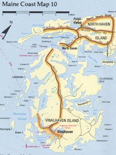
The map displayed above is from a pamphlet available in the Geospatial Center & Map Collection called Maine Geographic: Bicycling Maps.


The Geospatial Center & Map Collection summer hours are from 7:30 A.M. to 4:30 P.M. Monday through Friday.

Friday, July 07, 2006

BSU Walking Map


Take a Walk Around Campus

This map of the BSU campus shows distances covered for your daily exercise. The paths all originate near Bracken Library. The green path is a half-mile in distance; the red route is one mile; the yellow path covers one and a half-mile; and the purple line maps out a route covering two miles in distance.

This map was created by the GIS Specialist, Angela Gibson. Contact the GCMC if you would like a map created for your daily walking or biking regimen.

National Geographic Map Reveals Information About North Korea


Map of the Earth at Night

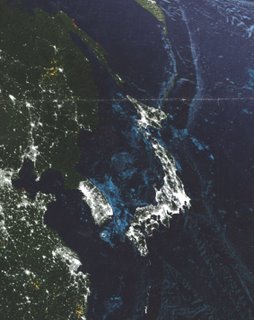
This image is a section of a map produced by National Geographic titled "Earth at Night." The map was created over a one-year period using satellite images from cloud-free nights. The purpose of the map is to show the bright lights of the developed countries of the world: the richest, most developed countries have the brightest lights. In this section of the map, Japan, the cities on the coast of China, and South Korea appear bright, while North Korea is markedly much darker. Recent events have put North Korea in the news, and news of energy shortages causing blackouts in the country have been reported. This map is evidence of the state of development in North Korea.

The National Geographic map shows the entire world at night, and is available for circulation from the Geospatial Center & Map Collection. The call number for the map is G3200 2004.N38. Staff of the center will offer assistance finding this map or any other resources needed for research.

Thursday, July 06, 2006

GCMC Maps Help Land Honda Plant

GCMC Maps Involved in the New Honda Plant

On June 28, 2006, the big story in Indiana newspapers was an article touting the news that Honda had selected a site near Greensburg, Indiana, for its latest vehicle assembly plant. According to the Anderson Herald Bulletin, this factory would produce 200,000 vehicles per year and provide at least 2,000 jobs to the local economy. Indiana competed with Ohio, Michigan, Wisconsin, and Illinois to be the home of the plant.

Before Indiana could compete for the Honda plant, however, the site had to be approved for development. The proposed site would require a survey to record the location of any significant archeological sites, such as burial grounds or historic villages. It was during this initial preparation phase of the development that maps from the Geospatial Center & Map Collection (GCMC) were involved.

Larry Stillwell, an Archeologist with Archeological Consultants of Ossian, borrowed maps from the GCMC to research the projected site. Stillwell is a Ball State University graduate (M.A. in Anthropology), and regularly uses the maps and soil surveys from the Map Collection for his business projects. Land may need to be surveyed to determine the locations of cell phone towers, road improvements, or the development of a huge factory as in this case. Stillwell may be studying a site as small as 90 square feet or as large as several thousand acres. The proposed Honda site is about 1,700 acres of land.

In preparation for the Honda project, Stillwell surveyed the parcel of land and recorded the locations of any archeological sites. In this case, he documented 141 sites. Stillwell did not classify any of the archeological sites as having significant value, so the development of the site could continue.

For the next part of his research, Stillwell visited the GCMC to consult topographic maps of the area in Decatur County. He copied relevant sections of the maps and transposed the archeological sites onto the copies of the maps. Stillwell then issued a report for the developer and forwarded the findings to the State Historic Preservation Office. The archeological report is then reviewed by the state, and the site may then be developed or further evaluated. The State Historic Preservation Office maintains a database including the recorded archeological sites from copies of the maps Stillwell makes in the GCMC.

Stillwell claims that 99% of all archeological sites recorded in the state are considered insignificant and would not delay development. Over 1,100 archeological sites are on file for Delaware County, Indiana.

The GCMC is a depository for maps and includes an extensive collection of USGS topographic maps covering the United States, both historic and current. Please contact the Center or visit the second-floor of Bracken Library if you would like to use topographic maps or any other kinds of maps for projects and research.

GIS Blog Offers Information for the World

"Geography Matters" Blog Available

ESRI is one of the leading developers of GIS technology software and educational services. ESRI developed many of the software programs such as ArcGIS, ArcView, and ArcInfo available for use in the GCMC GIS lab. The ESRI Web site is a valuable resource for GIS users--both beginners and professionals. Users can learn about new software technology and products, practice online tutorials, and find out about seminars and GIS conferences worldwide.

Now ESRI has added another valuable resource to their Web site--a blog about GIS called "Geography Matters." According to ESRI, this new blog "is an opportunity for you, the GIS community, to discuss how geography and GIS can improve many facets of our lives from sustainability to education to business and economic development." The "Geography Matters" blog currently features articles discussing the use of GIS in congressional redistricting, using GIS to map the mumps outbreak in the Midwest, and an entry discussing the use of GIS in disaster planning and emergency management in New Orleans. Users are encouraged to submit entries and links to other Web sites related to GIS and geography. The ESRI "Geography Matters" blog is located at http://blogs.esri.com/roller/page/geographymatters


Wednesday, July 05, 2006

Annual Statistics for the GCMC 2005-2006

The Numbers Are in...

Statistics covering the fiscal year 2005-2006 for the Geospatial Center & Map Collection:
  • Circulated Materials: 2,672
  • Maps Circulated via Interlibrary Loan: 50
  • Map/Atlas Reference Questions: 1,544
  • GIS Software Users: 190
  • Plotter Users: 789
  • Instructional Classes: 8 sections with 132 students
  • Collection Items Used: 12,233

June 2006 in the GCMC


BSU Backyard, 2004 Indiana State Fair

What's Happening in the GCMC? (June 2006 Edition)

Landscape Architecture students will once again be creating a display at the Indiana State Fair, "BSU Backyard." This year marks the 150th anniversary of the Fair, so a special display featuring the history of the Fair is being created in conjunction with the "Backyard." Carla Corbin, Associate Professor of Landscape Architecture, researched and borrowed several historic atlases, maps and aerial photographs of Indianapolis from the GCMC in preparation for this exciting exhibit.

The Center for International Programs will soon be sponsoring a study-abroad trip to Costa Rica and Panama, so many of the GCMC's maps of the region were reviewed in preparation and for promotion of the trip.

Members of the Environmentally Concerned Friends of Randolph County borrowed topographic maps and used digital maps from the GCMC for water quality testing sites.

Contact the GCMC for assistance completing class or community projects or planning a vacation itinerary.