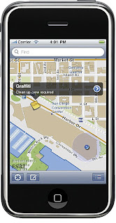
 GIS Software Available from iTunes
ESRI has made its GIS software, ArcGIS, available as a free download from the iTunes app store for the iPhone, iPad, and iPod Touch. The app provides access to ArcGIS Online, and allows users to navigate map galleries, access GIS data, display and zoom to a current location, and retrieve detailed map metadata.
Users can perform a keyword search and get access to relevant information. The search finds places, companies, and points of interest. The “Find Maps” button also allows users to view maps available online and add their own mapping service. Map tools allow users to find an address and coordinates of a location and measure area and distance. Topographic maps and Bing maps and aerial imagery can also be accessed. GIS information sharing with other iPhone users is encouraged.
For more information, please visit the ESRI Web page or ArcNews Online: http://www.esri.com/news/arcnews/summer10articles/arcgis-for-iphone.html
