Tuesday, April 22, 2014

Environmental Maps and Atlases Available from Ball State University Libraries


Soil degradation


Everglades 1973


Everglades 2002


Arctic Ice 1979

Arctic Ice 2003

The Cartography of Earth Day

Today is Earth Day, and the Ball State University Libraries’ GIS Research and Map Collection (GRMC) on the second floor of Bracken Library includes many resources for researchers studying issues of the environment.  The Map Collection includes flood plain maps for numerous areas, topographic maps that show development for areas around the world, soil surveys and maps from counties around the country, Gap Analysis electronic resources for land cover, forest types, and other factors, maps of important farmlands in counties around the United States, natural gas and other energy maps, and national and state park and forest maps.

The Atlas Collection also includes a number of resources about the environment.  The maps and photographs shown above are from the atlas One Planet, Many People: Atlas of Our Changing Environment, which was published by the United Nations Environment Program in 2005.  Atlases in the collection cover a broad range of environmental issues, including endangered species, polluted waters, urban development, and soil degradation (shown above).  Atlas of Contemporary America: Portrait of a Nation, Atlas of the Great Barrier Reef, World Atlas of Great Apes and Their Conservation, Ocean: An Illustrated Atlas, Atlas of Wildlife, and Atlas of Global Development also include maps about the environment.

For a complete list of environmental resources, researchers can access a cartographic research guide on the GRMC Web page.  For more information, please contact the GRMC at 765-285-1097.


Thursday, April 17, 2014

Maps in the News

Mapping Places in the News

The Ball State University Libraries' GIS Research and Map Collection (GRMC) houses a collection of over 140,000 maps available for research and learning.  Maps from around the world from the GRMC offer a great resource for learning about places in the news.


This map of Boston shows the location of the finish line of the Boston Marathon (click to enlarge).  The Boston Picture and Street Map was published by Olde South Publishing in 2000.


This is an inset map from the Titanic Reference Map available from the GRMC. The map shows the ship's reported and actual route and where rescue ships were located.  RMS Titanic sank on April 15, 1912. 


A ferry capsized off the coast of South Korea this week.  The ferry was traveling to Cheju-do Island seen at the bottom of this map (click to enlarge).  This map of South Korea was published by the Central Intelligence Agency.


Friday, April 18 marks the anniversary of the 1906 earthquake and fire in San Francisco. This panoramic map shows the city just after the disaster.  The map is featured on the San Francisco at the Millennium map in the GRMC.


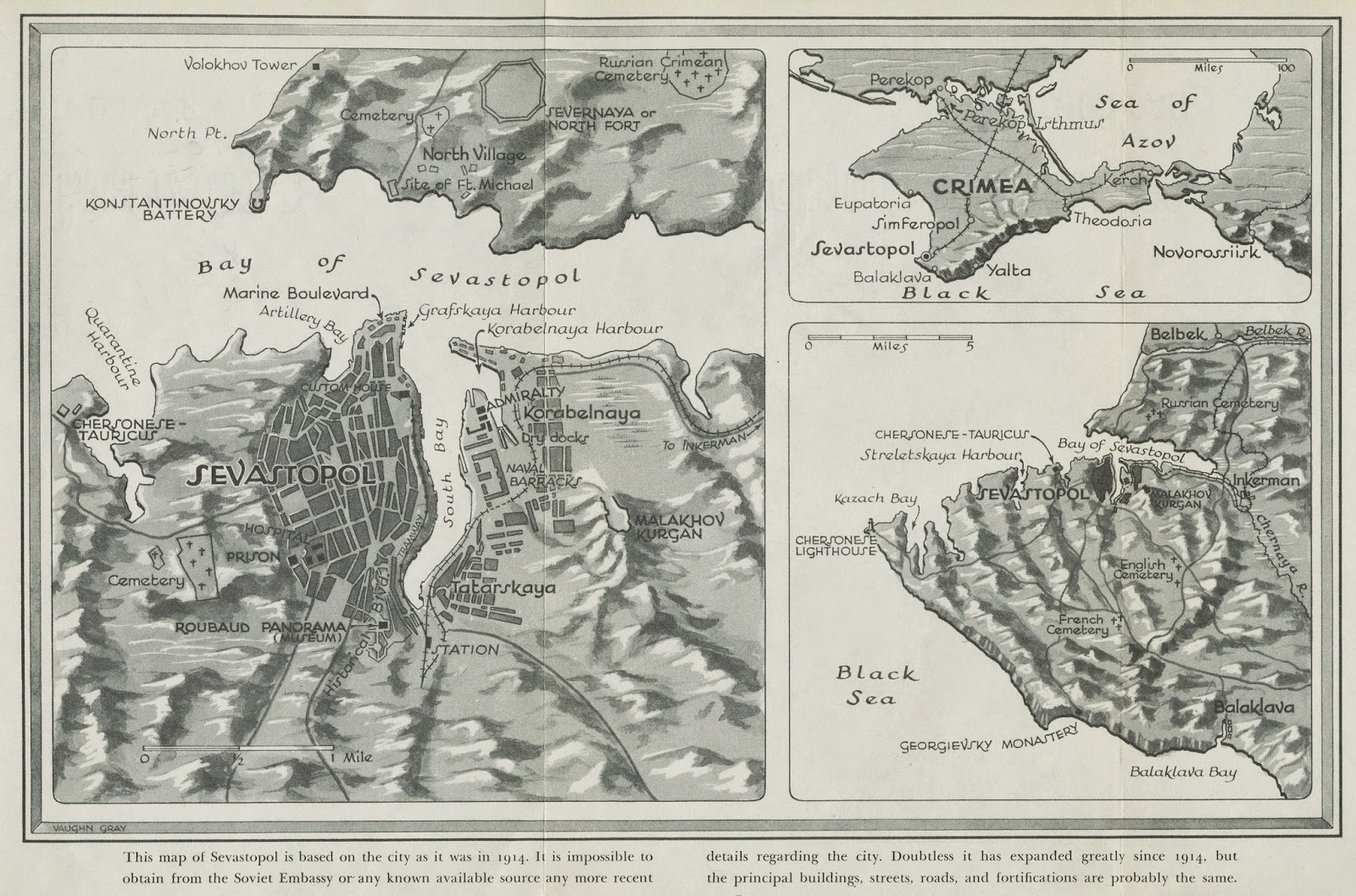
This map of Sevastopol, Crimea--formerly of the Ukraine--was published in the book, Last Days of Sevastopol by Boris Voyetekhov in 1943.  The map notes, "This map of Sevastopol is based on the city as it was in 1914. It is impossible to obtain from the Soviet Embassy or any known available source any more recent details regarding the city...."


April is Child Abuse Prevention Month.  This map shows the rates of reported child abuse and child fatalities due to abuse and neglect.  The map is from the Allyn Bacon Social Atlas of the United States available from the GRMC and the Atlas Collection in Bracken Library.

Maps from the GRMC circulate for two weeks or longer.  Atlases circulate for 28 days or longer.  For more information, please contact the GRMC at 765-285-1097.

Thursday, April 10, 2014

Speaker from The Polis Center at Ball State University Libraries


GIS Speaker at Ball State University Libraries

The Ball State University Geographic Information Systems (GIS) Knowledge Group is hosting a speaker at Bracken Library at 7:30 p.m. on Thursday, April 17.  Dr. David Bodenhamer will present From Historical GIS to Deep Mapping:  The Emergence of Spatial Humanities in Bracken Library room 104.

Dr. Bodenhamer is the Executive Director of The Polis Center and Professor in the Department of History at Indiana University-Purdue University at Indianapolis.  He has served as strategic and organizational consultant to universities, government agencies, and not-for-profit and faith-based organizations across the United States and in Europe.  An active researcher, Bodenhamer is author or editor of ten books and has published over 30 journal articles and book chapters.  He has presented to audiences on four continents ranging from legal and constitutional history to the use of GIS and advanced information technologies in academic and community-based research.

Bodenhamer’s works include The Spatial Humanities: GIS and the Future of Humanities Scholarship (Indiana University Press, 2010) and the forthcoming book Deep Maps and Spatial Narratives (Indiana University Press, 2014).

The Polis Center is a self-funded research unit of the Indiana University School of Liberal Arts at IUPUI. The Center works with professional and scholarly communities, especially through application of digital technologies such as GIS and other geospatial tools.  Major efforts include projects with national and state departments of homeland security, public health organizations, and research centers.

The presentation is free and open to the public.  Free parking is available in the Emens Parking Garage next to Bracken Library after 7:00 p.m.

For more information about the program, please contact Angela Gibson, GIS Specialist in the GIS Research and Map Collection at 765-285-1097.

Wednesday, April 09, 2014

Appomattox, Virginia Topographic Map Shows Site of Civil War Surrender


Appomattox on the Map: Map of the Site of the Civil War Surrender Available from Ball State University Libraries

On April 9, 1865 General Robert E. Lee surrendered to Lieutenant General Ulysses S. Grant at the home of Wilmer and Virginia McLean near Appomattox, Virginia.  The house is now included in the Appomattox Court House National Historic Park. 

The McLean House is identified on this U.S. Geological Survey topographic map (above, click to enlarge) from the Ball State University Libraries’ GIS Research and Map Collection (GRMC).  The GRMC houses thousands of these quadrant maps from around the United States.  These maps are an excellent resource for cartographic research and include relief lines, intermittent and permanent bodies of water, roads, government boundaries, and prominent buildings and other cultural features. Historic topographic maps and thematic maps about the Civil War are also available in the GRMC.

The second satellite image from Google Earth shows the McLean House and the surrounding buildings of the park.  The Web page, What Was There, features a photograph of the McLean House taken at the surrender that can be “faded” to see the house today.

Maps from the GRMC may be circulated for two weeks or longer.  For more information, please contact the GRMC at 765-285-1097.

Tuesday, April 08, 2014

Native American Documentary to Premiere in Muncie


The Lenape on the Wapahani River Documentary Premieres Saturday, April 12

A new documentary produced by students at Ball State University explores the source of names like “Muncie,” “Delaware County,” “Anderson,” and “Wapahani High School” and the interesting history of the Delaware Native Americans in Muncie, Indiana and will premiere on Saturday, April 12 at the Minnetrista Cultural Center at 1:00 p.m. 

The Lenape on the Wapahani River is the product of an immersive learning project taught by Chris Flook, Instructor in the Department of Telecommunications.  The documentary film was produced by students from the Departments of Telecommunications, Digital Storytelling, Natural Resources and Environmental Management, and Anthropology.  The project provides educational resources about the Delaware (or Lenape) Native Americans during their time in east central Indiana from the 1790’s through 1821. 

Partnering with the Delaware Tribe of Indians in Bartlesville, Oklahoma, and the Conner Prairie Interactive History Park in Fishers, Indiana, the project’s documentary and associated Web page provide a rich account of the Delaware’s often overlooked experience in Indiana.

The documentary will also broadcast on WIPB-TV on the following dates and times:

·         Sunday, April 13 at 12:30 p.m.
·         Monday, April 14 at 11:30 p.m.
·         Saturday, April 19 at 11 a.m.
·         Saturday, April 26 at 11 a.m.

The project was generously funded by the Hamer and Phyllis Shafer Foundation and was supported by the Building Better Communities Fellows program.  For more information about the film, please contact Chris Flook at 765-285-1480.

Tuesday, April 01, 2014

April Fools' Map Available from Ball State University Libraries


Skates or States? April Fools’ Map Activity from Ball State University Libraries

The Ball State University Libraries’ GIS Research and Map Collection (GRMC) creates custom cartographic resources for K-12 classroom teachers, including lesson plans, cartographic games, tutorials, and custom maps like the April Fools’ Map (above, click to enlarge).  Teachers can access the Cardinal Scholar institutional repository to print off and use many of these available resources from the GRMC for education and learning.

To find all of the available resources in Cardinal Scholar, click on “Browse by Communities and Collections.”  Scroll down to the Information Technology section:  The GRMC will be listed under “University Libraries.”  From the GRMC page, click on “browse by title.”  A list of resources including maps, posters, lesson plan ideas, and classroom activities will appear.  A search by subject or keyword is also available.  The GRMC is constantly updating the educational resources, so check for new additions from time to time.

Teachers can click on the title of the resource and save it for use in the classroom.  The lessons range in scope and grade level.  A lesson plan guide, Teaching with Maps, provides sample maps and lessons for teachers of social studies, science, English, and economics.  Other guides available from Cardinal Scholar including cartographic guides on women’s history, Black history, using Sanborn insurance maps in the history classroom, maps and map projections, and genealogy resources.

The April Fools’ map features labels of cities, states, lakes, crops, abbreviations, and mottoes that are incorrectly placed around the United States.  The map provides a good review of basic United States geography, and an answer sheet is included in the PDF file on Cardinal Scholar.

For more information about using Cardinal Scholar or any of the teaching materials, please contact the GRMC at 765-285-1097.

Monday, March 31, 2014

Baseball Maps Available from Ball State University Libraries


Opening Day: Baseball Maps Available from Ball State University Libraries

It’s Opening Day at ballparks around the country, and the Ball State University Libraries’ GIS Research and Map Collection (GRMC) offers baseball fans and others a glimpse at some baseball-related maps.

The GRMC includes a travel map locating all of the Major League Baseball stadiums.  The map also includes contact information for every major league, minor league, and independent professional baseball team in the U.S. and Canada.  

The Atlas of Sport available in the Atlas Collection features maps on the “American game,” including the map shown above (click to enlarge) depicting the number of high-school boys playing baseball in school leagues, with Iowa (site of Field of Dreams) leading the nation.

The GRMC has also created custom maps related to the history of baseball.  Black Diamonds: Negro League Baseball Teams, 1920-1949, (shown above) was created in association with the documentary Black Baseball in Indiana, a film created as an immersive learning project by students of Geralyn Strecker, Assistant Professor in the Department of English.  This map shows the location of the Negro League teams in the United States.  Photographs featured on the map are from the book Playing America’s Game by Michael L. Cooper.  The map is available for use from the CardinalScholar repository.  Copies of the map can be printed on the large-format plotter in the GRMC (charged to Bursar’s account) for exhibits, for use in the classroom, or personal use.


Another map, The Girls of Summer: All-American Girls Professional Baseball League Teams, 1943-1954, (click to enlarge above) commemorates the women who played professionally beginning during World War II.  The map was created for Women’s History Month and is based on the book A Whole New Ballgame: The Story of All-American Girls Professional Baseball League by Sue Macy available from the Educational Resources Collections.  This map is also available from Cardinal Scholar.  All maps are also available via interlibrary loan. 

For more information about these or other cartographic resources, please contact the GRMC at 765-285-1097.

Thursday, March 27, 2014

Oso, Washington Interactive Map


The New York Times created an interactive aerial map showing where houses and other structures were located before the landslide in Oso, Washington on Saturday.  Nearly fifty homes were located in the path of the mudslide made up of 15 million cubic yards of mud--three million dump truck loads left in the search field.  (The map above is from the British Broadcasting Corporation). 


Holy See/Vatican City Maps Available from Ball State University Libraries


Maps in the News:  Vatican City Maps Available from Ball State University Libraries

Today marked a historic first meeting between President Barack Obama and Pope Francis in Vatican City.  Ball State University Libraries’ GIS Research and Map Collection (GRMC) on the second floor of Bracken Library features several maps of Vatican City.

Vatican City is located completely with the city of Rome, Italy, and the “popout” map of Rome is a small folded map published in 2008 that includes a map of the grounds.  A 1995 National Geographic map of Italy also features an inset map of the grounds of the Holy See. 

The top map shown above was published by the Central Intelligence Agency and shows the location of the radio station, the post office, and the Papal Printing Office.  The second map shown above is a topographic map of Rome published by the Defense Mapping Agency by the War Office in 1943.

The third map shown of the Vatican City, Citta Del Vaticano, was published by the Visceglia Geographic Institute in Italian.  St. Peter’s Square is identified as “Piazza S. Pietro” on the map, and “Giardini Vaticani” marks the location of the gardens.  “Pinacoteca” is the Art Gallery located on the grounds.

Maps from the GRMC may be circulated for two weeks or longer.  The GRMC is open Monday through Friday from 8:00 to 5:00.  


Friday, March 21, 2014

Map of Exxon Valdez Oil Spill from Ball State University Libraries


Exxon Valdez Oil Spill Map from Ball State University Libraries

Monday, March 24 marks the 25th anniversary of the Exxon Valdez oil spill in Alaska.  The Valdez oil tanker ran aground in Prince William Sound, spilling millions of gallons of crude oil.  The map shows how the oil spill covered over 1,200 miles of shoreline.

The map above (click to enlarge) is from Mapping America’s Past: A Historical Atlas by Mark C. Carnes available from the Ball State University Libraries’ GIS Research and Map Collection on the second floor of Bracken Library.  This reference atlas features maps ranging from exploration, colonization, wars, and political issues to gender, ethnicity, education, religion, disease, and other demographics.  The atlas features detailed maps about the “making of Black Harlem” in New York, airports constructed by the WPA during the Great Depression, and maps of Levittown, Pennsylvania.

For more information, please contact the GRMC Monday through Friday from 8:00 to 5:00 at 765-285-1097.


Ball State University Libraries' YouTube Channel


Moving Pictures:  Ball State University Libraries’ Map Collections on YouTube

The Ball State University Libraries’ Digital Media Repository (DMR) provides online access to hundreds of digitized primary source materials, including artwork, architectural drawings, films, photographs, oral histories, and maps and atlases.  Historic maps and atlases from the GIS Research and Map Collection (GRMC) in Bracken Library can be accessed through the repository, and now can be viewed on YouTube.

The University Libraries’ YouTube channel allows users a different format for viewing some of the resources from the Digital Media Repository.  The Muncie and Delaware County Historical Maps Collection YouTube video includes historic plat maps of Muncie, maps from historic atlases, Sanborn Fire Insurance Maps dating back to the nineteenth century, and historic maps of the White River.

The Digital Media Repository provides access to several map collections:  The United States Transportation Maps collection includes historic railroad and road maps.  Ball State University Campus Maps show maps of the university dating back to the 1920’s.  American Cities Historic Maps features unique maps or urban views from 1855 through 1921.  Indiana Natural Resources Maps includes maps showing the locations of stone quarries, pipelines, and natural gas, coal, and petroleum deposits around the state.  International Historic Maps is an eclectic collection of maps from around the world, including a War Department map of Cuba published in 1911 and an 1867 map of the Ottoman Empire. Maps of the World is an excellent resource providing the most up-to-date maps of over 200 regional and national maps published by the Central Intelligence Agency.  Delaware County Aerial Plat Maps, Indiana Historic County Atlases, United States Soil Maps, and United States Topographic Maps are also available from the Digital Media Repository.

The GRMC is constantly adding resources to the DMR to enhance access to research and learning.  For more information about these collections and information about other cartographic resources, please contact the GRMC at 765-285-1097.
Monday, March 17, 2014

Ireland Maps Available from Ball State University Libraries


Happy St. Patrick's Day: Ireland Cartographic Guide Available from Ball State University Libraries

Students and other researchers of Ireland and Irish history can access a cartographic guide to resources available in Ball State University Libraries via the GIS Research & Map Collection (GRMC) Web page.  The subject guide, CartographicResources in Ball State University Libraries: Ireland and Irish History, can help researchers locate a variety of materials throughout the Library.

This guide provides a list with call numbers and locations of all of the maps, atlases, encyclopedias, and other resources available from University Libraries.  There are atlases for Celtic studies and Irish history in the Atlas Collection and also an atlas focusing specifically on Irish family histories, New Genealogical Atlas of Ireland.

Street maps for numerous cities in Ireland, nature reserve maps, topographic maps of Ireland, and maps covering Irish history are available from the GRMC.  The Irish Family Names Map features coats of arms and medieval locations, and maps showing the peat land and fishing resources of Ireland are also available.

The guide also includes a listing of a set of reproduced historical maps from the National Library of Ireland that are not yet cataloged but do circulate for two weeks or longer individually or as a set.  The maps shown above are from the Census Atlas of the United States, depicting the percentage of the population reporting Irish ancestry in the 2000 Census and the foreign born Irish population centers in 1900.

The cartographic guide is also available from Cardinal Scholar.  An Ireland map poster can also be accessed from Cardinal Scholar and used for research and learning in the classroom or for special presentations.

For more information about these resources or the cartographic guides, please contact the GIS Research & Map Collection at 765-285-1097.


Friday, March 07, 2014

Ball State University Libraries Presents Women's History Month Map Program


Women in the World:  The Geography of Women’s History Presentation

The Ball State University Libraries’ GIS Research and Map Collection (GRMC) on the second floor of Bracken Library is celebrating Women’s History Month with special public presentations in Muncie.  Women in the World is a special maps program created by the GRMC that will be held in two different sessions—2:00 pm to 3:00 pm and 6:00 to 7:00 pm—on Monday, March 17 at the Cornerstone Center for the Arts in downtown Muncie at 520 East Main Street.

The program will feature maps about women’s issues around the world.  Maps depicting education and employment inequality, women in government, healthcare issues facing women around the world, and discrimination and advancements in society will be shown.  Other maps showing contributions of women in history will also be featured in the program.

The GRMC has created a special collection of online maps for Women’s History Month available from the Ball State University Libraries’ CardinalScholar institutional repository.  These include maps about women working in agriculture, women heads of state, women in tertiary teaching, and countries with high breast cancer rates.  Type “women in the world map” in the search box to see the available cartographic resources. 

Please contact the Cornerstone Center at 765-281-9503 to reserve a spot for the program.  Free parking is available.


Tuesday, March 04, 2014

Online Women in GIS Map


Celebrating Women’s History Month:  Crowd-Sourced Map of Women in GIS
From Caitlin Dempsey, GIS Lounge

In honor of Women’s History Month, Dr. Linda Loubert of Morgan State University is attempting to create a crowd-sourced map of women in GIS.  Dr. Loubert requests women working with GIS, in the GIS industry, teaching GIS, or GIS students to contribute to the map.

The map is dotted with GIS professionals categorized by their industry—academia, private sector, nonprofit, government.  So far most of the submissions are based mainly in the United States.  Users can zoom in to see other GIS professional women working in various areas of a state or city.

To add personal information to the map, click “edit.”  Choose the appropriate symbol designation for the particular GIS occupation sector, and add a dot.  Users can also add photographs, maps, or relevant Web pages.

For more information about the map, please contact Dr. Linda Loubert at Morgan State University. Caitlin Dempsey is the editor of GIS Lounge.  

Maps of New Orleans Available from Ball State University Libraries


Mardi Gras Maps in the News:  New Orleans

The Ball State University Libraries’ GIS Research and Map Collection (GRMC) is featuring a map of New Orleans, Louisiana for the “Map of the Month” exhibit.  The map is a collector’s edition aerial perspective of the city drawn by Carlos Diniz and is displayed in the windows of the GRMC on the second floor of Bracken Library.

The GRMC includes dozens of historic and modern maps of New Orleans.  The New Orleans “popout” map is a great resource for travelers.  This map folds up to pocket-size and includes maps of greater New Orleans, the French Quarter, downtown, and the Garden District.

The travel map of the French Quarter (above—click to enlarge) depicts the world famous Bourbon Street in the center.  This map is colorfully illustrated and was published as a souvenir map for Mardi Gras and other tourist events.

The GRMC also includes maps of the flooding of New Orleans after Hurricane Katrina, topographic maps noting the elevation lines and showing the canals and levees of the city, maps and nautical charts of the intracoastal waterway and Mississippi River, and historic bird’s eye views of the city and the harbor.

Maps from the GRMC circulate for two weeks or longer.  For more information, please contact the GRMC at 765-285-1097.


Monday, March 03, 2014

Bruce F. and Ildiko B. Meyer Endowed Lecture Cancellation

The lecture and illustrated talk with Sharon Liberman Mintz scheduled for tonight (Monday, March 3) in Bracken Library has been cancelled due to travel problems for the speaker.  Updates with information about a possible rescheduled date will be forthcoming.

Thursday, February 27, 2014

Ukraine and Crimea Maps Available from Ball State University Libraries


Maps in the News:  Unrest in Ukraine

The Ball State University Libraries’ GIS Research and Map Collection (GRMC) on the second floor of Bracken Library has a large collection of maps of the Ukraine available for research and learning.  Cartographic resources can be an excellent visual resource, and the maps and atlases in the collection include both historic and new maps of Ukraine, its cities and provinces, and maps of the former Soviet Union.

The collection includes cities in Ukraine, including new and historic maps of Kiev, Dnipropetrovsk, and Kirovohrad.  A unique map of Zakarpattia Oblast and maps of the autonomous region of Crimea published in Russian (inset shown above—top, click to enlarge) are also included in the collection. 

Folded tourist and road maps of Ukraine are also available in the GRMC.  Some of the maps are published in Hungarian, German, French, Russian, and English and include neighboring republics.  The GiziMap of Ukraine features physical relief and tourist areas including Kiev and the Crimean Riviera.

The map above Territory Settlement of Ukrainian People is an ancillary map published by the League of Americans of Ukrainian Descent and the State Organization of Ukrainian Congress Committee of America in 1955 in Chicago.  The colorful historic economic, travel, and tourist map of the Ukraine (yellow background above) was published in the 1960’s as part of the Soviet Union and shows some of the industries and travel routes of the republic. 

The Atlas Collection also provides great resources for studying the Ukraine and the former Soviet republics.  Atlas of Russia and the Independent Republics includes maps about natural features, history, population, and communications networks of Ukraine and the other republics.  Ukraine: A Historical Atlas includes maps covering every period of different rulers of the region.  Other atlases of the former Soviet Union and regions of Ukraine published in Russian are also available in the Atlas Collection. 

The U.S. Central Intelligence Agency publishes updated maps of countries, and these new maps can be accessed digitally via the University Libraries’ Digital MediaRepository in the Maps of the World collection.  The historic map of the Ukraine (bottom map shown above) is also available in the repository and was published in 1921 in an Indiana atlas.

Maps from the GRMC circulate for two weeks or longer.  Atlases from the Atlas Collection circulate for 28 days or longer.

The complete collection of maps of the former Russian republics has not yet been cataloged, so visit or contact the staff of the GRMC at 765-285-1097 to discover maps not listed in the library CardCat system or for more information about any of these cartographic resources.


Tuesday, February 25, 2014

Jewish Art History Presentation at Ball State University Libraries


Jewish Art History:  2014 Bruce F. and Ildiko B. Meyer Memorial Lecture at Ball State University Libraries

The Friends of A.M. Bracken Library together with the Honors College and the Zeigler Committee for Jewish Studies is sponsoring the Bruce F. and Ildiko B. Meyer Memorial Lecture—Celebrating Marriage in Jewish Art: Medieval and Early Modern Perspectives.  Sharon Liberman Mintz, Curator of Graphics at the Jewish Theological Seminary of America and Senior Consultant of Judaica at Sotheby’s, will present this illustrated talk on Monday, March 3 at 7:30 pm in Bracken Library room 104.

The celebration of Jewish marriage in the medieval period is visually recorded in a selection of Hebrew manuscripts that document the customs of European Jewry.  Complementing the medieval perspective, in the Early Modern era, the practice of decorated and illustrated ketubbot (Jewish marriage contracts—shown above) provides a wealth of information concerning the artistic creativity, cultural interactions, and social history of the Jewish communities in which they were created.

Researchers of Jewish history will find extensive cartographic resources available from the Ball State University Libraries’ Atlas Collection and the GIS Research and Map Collection (GRMC) on the second floor of Bracken Library.  The GRMC includes hundreds of maps of Israel, Jerusalem, and the Holy Land.  The Atlas Collection includes several books covering Jewish history—The Illustrated Atlas of Jewish Civilization, Atlas of Medieval Jewish History (map above--click to enlarge), Atlas of Jewish History, Atlas of Modern Jewish History, The Penguin Atlas of Diasporas, and The Routledge Atlas of Jewish History published in 2010.

The presentation is free and open to the public.  Free parking is available after 7:00 pm in the Emens Parking Garage.  For more information please contact John Straw, Assistant Dean for Digital Initiativesand Special Collections, at 765-285-5078 or Dr. Frank Felsenstein at 765-285-8405.

University of Athens Professor to Speak at Ball State University


Geography of Art:  Ancient Art Expert to Visit Ball State University

Internationally noted iconographer, Dr. George Kordis, Assistant Professor in Iconography Theory and Practice at the National and Kapodistrian in the School of Theology at the University of Athens, will present a lecture on ancient art at the Ball State University Student Center Ballroom.  Icons and Iconography: An Ancient Art Form in the Modern World will be Monday, March 3 at 7:30 pm. 

Dr. Kordis will discuss the technique of icon painting and the study of iconography.  Kordis and his team are visiting Indiana to add to the iconography programs of St. George Antiochan Orthodox Church in Fishers and Holy Trinity Greek Orthodox Church in Carmel.

The Byzantine Empire map and image above (click to enlarge) are from the atlas, Great Empires: An Illustrated Atlas, published by National Geographic and available from the Ball State University Libraries’ Atlas Collection in Bracken Library.  The Atlas Collection also includes other cartographic resources about art, including Atlas of World Art published in 2004, Atlas of Western Art History by John Steer, and Atlas of the Early Christian World.

The event is free and open to the public.  The Ball State University Orthodox Christian Fellowship is sponsoring the event.  For more information, please contact Zachery Hayden, student leader or Dr. Martha Payne, advisor.

For more information about the Atlas Collection, please contact the GIS Research and Map Collection at 765-285-1097.


Tuesday, February 18, 2014

Mapping the Sochi Winter Olympic Games


Maps in the News:  Mapping the Sochi Winter Olympics Medals

ESRI, leading supplier of Geographic Information System (GIS) software and geodatabase management, has created a Winter Olympics Live Medal Tracker map page.  “See the latest live medal county by country and find out who’s leading in the overall count, as well as the counts for each medal.  Click a medal to see how many each country has won.”

Ball State University Libraries provides access to ESRI GIS software on computers on every level of Bracken Library and the Architecture Library and Science-Health Science Library.  The GIS Research and Map Collection (GRMC) on the second floor of Bracken Library offers access to the leading GIS software and online GIS tutorials, datasets, online mapping applications, in-house GIS data, and one-on-one assistance from the GIS Specialist.

The GRMC is open Monday through Friday from 8:00 to 5:00 pm.  For more information, please contact the GRMC at 765-285-1097.  


Monday, February 17, 2014

Ball State University Libraries Black History Month Maps


Black History Month Maps:  The Tuskegee Airmen


The Tuskegee Airmen National Historic Site was dedicated this weekend near Tuskegee, Alabama.  The site includes a restored Hangar 2 at Moton Field that will serve as a museum featuring artifacts and oral histories of the Tuskegee Airmen.  The Skyway Club, where the airmen relaxed, will include furnishings from the 1940’s. 

The Tuskegee Airmen were the first African American military pilots, serving in World War II.  The map above (click to enlarge) shows locations of the over 1,000 missions flown by the airmen during the war.  The map is from the Atlas of African American History by James Client and is available from the Atlas Collection on the second floor of Bracken Library.  The Atlas of African American History and Politics: from the Slave Trade to Modern Times by Arwin Smallwood is also available for research and learning.

For more information about these cartographic resources, please contact the Ball State University Libraries’ GIS Research and Map Collection at 765-285-1097.


Monday, February 03, 2014

Black History Month Celebrations at Ball State University Libraries


Black History Month Presentation and Map:  Trials, Triumphs, and Trailblazers: Historic Women in African American History

The Ball State University Libraries’ GIS Research and Map Collection (GRMC) on the second floor of Bracken Library is celebrating Black History Month with a special public presentation in Muncie.  Also a custom map about African American history is displayed in the GRMC windows as a commemorative exhibit.

The Geography of Black History is a special Black History Month program created by the GRMC.  The program will be held in the Auditorium of the Cornerstone Center for the Arts in downtown Muncie at 520 East Main Street on February 12 from 6:00 to 7:00 p.m.  Free parking is available, and the presentation is open to the public.  Registration is not required, but anyone interested in attending can call the Cornerstone Center at 281-9503. The program will present maps depicting major events and figures in Black history, including custom maps featuring great figures in Indiana history.

The GRMC is also presenting a map exhibit featuring a custom map of historic women in African American history (above, click to enlarge).  The map, Trials, Triumphs, and Trailblazers: Historic Women in African American History, shows well-known women from Harriet Tubman to Condoleezza Rice, but also some lesser known women from history.  Descriptions of the women’s accomplishments are listed on the map.  This map includes photographs from the University Libraries’ Digital Media Repository’s The Other Side of Middletown collection.  The map is available for use in research and education from the Cardinal Scholar institutional repository. 

Other custom maps from the GRMC celebrating great events and people in African American history can also be accessed from Cardinal Scholar.  Maps showing the Negro League Baseball teams, a map about the life of Madam C.J. Walker, a map of the life of Dr. Martin Luther King, Jr., and previous Black History Month exhibit posters with maps from atlases are all available from this online resource.  Users can search "Black History Month" in the search box of Cardinal Scholar to review all of the available maps and posters.

For more information about the Black History Month program or any of the maps in the GRMC, please call 765-285-1097.  For more information about the Digital Media Repository collections, please contact the Archives and Special Collections at 765-285-5078.