Tuesday, January 30, 2007

More Google-related Maps

...and More Maps from Google

The Google Books search has recently added a new feature to some of its entries. When searching for a book in the library of Google Books, users can now find maps that map out the events of the book. Using the Google Books search, click on the "About this Book" feature. This section shows where the book may be purchased, libraries where the book may be borrowed, related books, references from scholarly works, and other editions of the book. Some books included in the Google library also include a map of the events of the book listed under the section "Places Mentioned in this Book." This feature is being added to more books, but the following are some of the books that include maps: Howards End by E.M. Forster, Les Miserables by Victor Hugo, Ivanhoe by Sir Walter Scott, and, of course, Around the World in Eighty Days by Jules Verne. These world maps include markers where events in the book took place with pages of the book referenced below the map. Recently a student teaching an elementary class about Around the World in Eighty Days created a game where the students mapped out the events of the book using maps from the Geospatial Center & Map Collection. And now Google allows readers to accomplish this with a click of the mouse.

January 2007 Map Displays

"New" Map Displays in the GCMC

The "Map of the Month" for January 2007 in the Geospatial Center & Map Collection was a USGS topographic map of Ellis Island in New York. Ellis Island opened as a new immigrant screening station in January of 1892.

A 2004 map of Iran is the featured map in the "Maps in the News" section of displays.

Student-assistant Casey Gentis created this "Happy New Year Map of the United States" for display. The map features place names in the United States with the word "new."

Also featured in the windows of the GCMC is a GoogleEarth image of Dolphins Stadium in Miami, site of the 2007 Super Bowl.

Visit the GCMC to view the map displays or to borrow maps for a project, class assignment, or to display during a speech or presentation.

Economic Maps from Yale

3-D Economic Maps from Yale

The G-Econ Project was designed by researchers at Yale to display the world's economic activity using a one-degree grid. A map of the world and maps of individual countries and data sets are available at the project website, http://gecon.yale.edu.

The basic metric is the regional equivalent of gross domestic product. The economic activity displayed on the maps matches closely to cities and areas of large industrial activity, as shown on this map of Canada. Most of the cities of Canada are along the border with the United States, and the economic activity matches that trend.

Professor William Nordhaus of Yale is the project director. The GIS lab in the Geospatial Center & Map Collection in Bracken Library is available for GIS users working on similar projects.


Friday, January 26, 2007

English Class Assignment in the Library

Scavenger Hunters in the GCMC

English 104 students in Elizabeth Nesbitt's classes were given an assignment to complete a scavenger hunt in Bracken Library. Students were asked to cite different materials found in the Library, and part of the assignment included citing a map that was related to their college major. Many of the students were surprised to find such a large variety of topics covered by maps and atlases in the Geospatial Center & Map Collection and Atlas Collection.

Students majoring in history and political science found hundreds of maps and atlases related to their majors. Many of the history students chose to cite actual maps dating from World War II. Others were interested in looking at maps about the Civil War, westward expansion, or Vietnam. A map showing the results of all of the presidential elections was a popular choice with political science students. Some students cited maps included in the Atlas of American Politics.

Sociology and anthropology students asked for maps related to Native Americans, life in ancient Egypt, or maps related to world religions. Science and natural resources and environmental management students were interested in maps about endangered species, water conservation, and a map of wildlife refuges. A student studying to become a meteorologist requested the map, Most Intense Tropical Storms of 1998. Some science students cited the map titled Earth at Night, but this map was also cited by economics students since the lights of the map show development.

A music student cited the Titanic Reference Map since the map discusses the music played on the ship. An art student cited a map found in the Atlas of Western Art History. English and writing majors cited the Map of the Limberlost, a map showing American folklore characters, a map about the Harlem Renaissance, Shakespeare's Britain, and the Literary Map of Indiana.

Sports management students cited maps from atlases on sports or specifically golf or the Soccer Unites the World or the Baseball Travel Map. A construction student cited a map about the architecture of Rome. Nursing students discovered many maps and atlases related to health issues. Many of the students used atlases for the assignment. The Tobacco Atlas includes many maps related to health and health education. Some of the students used maps in the atlas showing tobacco deaths, female smokers, and youth smokers, and maps showing where education is provided to help smokers quit.

Another atlas was used by students in nearly every major. The State of the World Atlas by Dan Smith includes maps about life expectancy at birth, quality of life, investment, world markets, debt, literacy, religion, health risks, reproductive rights, communication and media around the world, and biodiversity. So this atlas proved popular with students searching for a map related to many different types of issues related to many different majors.

This assignment not only taught students about how to use the library and write bibliography citations, but also provided an opportunity to learn about all the different resources the library has available for further research and learning. Please contact the Geospatial Center & Map Collection if interested in planning an assignment for the classroom.

Thursday, January 25, 2007

Historical Aerial Photography in the GCMC

Pictures of the Past: Aerial Photographs in the GCMC

GoogleEarth has popularized the use of aerial photography in research, and these images are becoming more common in everyday use. GoogleEarth is available on the computers in the GIS lab in the Geospatial Center & Map Collection. Digital images of current aerial photography for the state of Indiana is also available for download from the Indiana University GIS website. And the GCMC has digital access to the most recent aerial photography for Delaware County. But the Center is also an excellent resource for historic aerial photography from all over the United States and even parts of Australia.

Complete sets of aerial photography at 1:100-feet and 1:400-feet scales for Delaware County are available for research. The dates of the photography are 1974, 1979, 1982, 1985, 1987, 1992, and 1997. These sequential photographs are an excellent tool for viewing changes in the landscape of an area over time. Recently a graduate student in Architecture used four aerial photographs of the same site in Muncie dated at intervals of five years to study the development around her research site. The number of buildings added in each progressive photograph was quite dramatic.

Some development of Marion County can be studied using aerial photographs of the county in the GCMC. Two sets of aerial photographs at 1:100-feet scale from Marion County are available. The dates of these sets are 1985 and 1994.

The GCMC also has historic aerial photography in the 1:400 feet scale of other Indiana counties: Grant County, 1984; Hamilton County, 1985; Henry County, 1993; Madison County, 1985; Monroe County, 1993; and Randolph County, 1993. Smaller aerial photographs of other Indiana counties are also available as reference materials in the GCMC: Boone County, 1939 and 1955; Carroll County, 1938, 1939, 1951, 1952, and 1958; Pulaski County, 1938 and 1957; and White County, 1938, 1939, 1951, and 1958.

The GCMC also has historic orthophotoquad maps and orthophoto maps of most of the United States. Orthophotoquad maps are aerial photographs layered onto the USGS 1:24,000 topographic quadrangle maps. The orthophotomaps are usually color versions of similar maps. Most of these maps are 1:24,000-scale maps. The GCMC contains sets of maps from all but nine states--Arizona, Kansas, Kentucky, Montana, New Jersey, New York, North Dakota, Ohio, and Rhode Island. The GCMC has orthophotoquads from all other states. The sets of maps from Florida, Georgia, North Carolina, Texas, and Virginia are exceptionally thorough. The maps of Alaska include satellite image maps and radar image mosaic maps. (The image of the region of Ugashik is shown above).

The GCMC also houses sets of aerial photographs of parts of Australia. The largest coverage is of South Australia. A new (2005) set of topographic maps of New South Wales was recently added to the Collection.

With the exception of the smaller reference materials of Boone, Carroll, Pulaski, and White Counties, the entire collection of aerial photography may be checked out from the GCMC for two weeks. Please contact the GCMC with any questions about using historic aerial photography for research and learning.

Thursday, January 11, 2007

Historical Maps on the Web

Making History on Desktops

Several historical resources are now available on the Internet, matching historic maps and charts with modern technology:

The National Oceanic and Atmospheric Administration has made available 21,000 maps and charts dating from 1655 to 2001. This site includes downloadable images of aeronautical charts, base maps, city plans, Civil War maps, fishing/bathymetric charts, topographic maps, plat maps, nautical charts, and even sketch maps. Maps can be located through a keyword search or by type, year, or region. (The map shown is a map of the battlefield at Antietam). This site is located at http://historicals.ncd.noaa.gov/historicals/histmap.asp.

Another useful site lists over 1,200 historic map images available on the Internet: Map History/History of Cartography: The Gateway to the Subject: This site is "the only comprehensive listing of its kind...and is updated at least every two months." The listing of maps is organized by continent and has a separate section of thematic maps. This site is located at http://www.maphistory.info/webimages.html.

Another historical resource was added in November 2006 to commemorate Geography Awareness Week. Sixteen maps from the David Rumsey Historical Map Collection were uploaded to the featured content layer of Google Earth. Users can view the historical maps overlay and compare the old maps to the modern world. More information about the David Rumsey Historical Map Collection is available at http://www.davidrumsey.com/.

The Geospatial Center & Map Collection and the Archives & Special Collections Research Center in Bracken Library contain historic maps and atlases of various places dating back to the 19th century. Please contact the Center for more information about using these historic resources in research.

Monday, January 08, 2007

2006 GCMC Events

2006: Geospatial Center & Map Collection Year in Review

Students from a variety of classes visited the GCMC in 2006 to use the maps, atlases, GIS software, and other resources available in the Center. In fact the list of classes is extremely diverse: Geography, Urban Planning, Historic Preservation, Landscape Architecture, Architecture, Archaeology, Anthropology, Geology, History, Art, Communications, Journalism, Modern Languages and Classics, Creative Writing, Music, Global Studies, Construction Management, and Biology. The Center also hosted students working on projects from Elementary Education, Social Studies methods, Natural Resources and Environmental Management, Economics, Political Science, Physics and Astronomy, Sociology, Spanish, and English.

Visitors to the GCMC were international: The Center hosted tours to visitors from Deyang, China; Seoul, South Korea; Malawi; the Republic of Georgia; and Germany.

Keeping track: 2,487 items were circulated from the GCMC in 2006; 1,636 reference questions were researched using 12,356 items in the room; GIS software was used 228 times; 1,093 people used the plotter for printing; 34 maps were circulated through Interlibrary Loan; and 22 classes with 304 participants were given instructional sessions.

Contact the GCMC for information about any of these services and resources. The Center is open Monday through Friday from 8:00 to 5:00.

Friday, December 22, 2006

December Map Displays

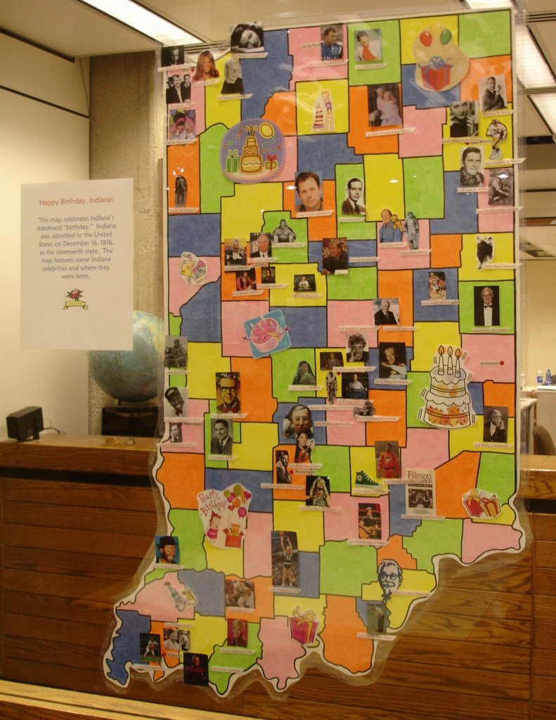
December Map Displays: Happy Birthday, Indiana

Hannah Hilleson, student-assistant in the Geospatial Center & Map Collection, created this map showing famous people born in Indiana. The map commemorates Indiana's "birthday" (admission to the Union) in December 1816. The map reveals the birthplaces of famous Hoosiers in many fields of public life. This map marks Hannah's last project for the GCMC due to her December graduation. Hannah has worked in the GCMC since the fall of 2002.

The December "Map of the Month" is the National Geographic sixtieth anniversary edition map of Pearl Harbor.

Visit the GCMC on the second floor of Bracken Library to view these displays and many others.

College Football Bowl Games on the Map

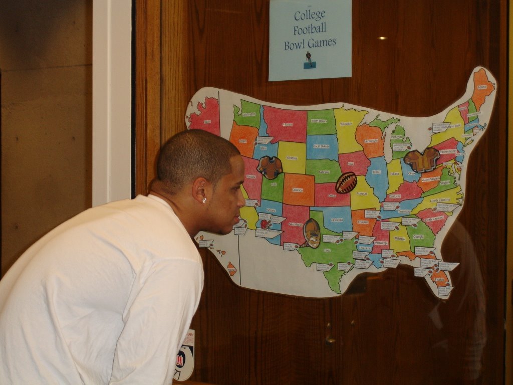
Going Bowling: College Football Bowl Games on the Map

The college football bowl season kicked off this week with the Poinsettia Bowl in San Diego, California, on December 19. A map showing the locations of the 32 major bowl games is on display in the window of the Geospatial Center & Map Collection on the second floor of Bracken Library.

Most of the bowl games are located in the southern part of the United States, but Toronto, Detroit, and Boise are also sites for the games. Florida hosts five bowls, with California, Texas, and Louisiana hosting four. The National Championship game will be in Glendale, Arizona, on January 8.

Visit the GCMC to view this map and other map displays over the holiday break. Please contact the Center with questions about this map or any other information.

Wednesday, December 13, 2006

December GCMC Hours

December Geospatial Center & Map Collection Hours and Closings

The GCMC will operate with regular hours during finals week and the semester break--Monday through Friday 8:00 A.M. to 5:00 P.M. The Center will close at 3:00 P.M. on Friday, December 22 and Friday, December 29. The GCMC will be closed on December 25, 26, and January 1. Please contact the GCMC staff at (765) 285-1097 with any questions.

Tuesday, December 05, 2006

Google Earth Greetings


More Uses of Google Earth: Sending Holiday Greetings

The creator of the website www.geogreeting.com was using Google Earth when he realized that many of the buildings in the satellite images resembled letters of the alphabet, so he decided to use the "letters" to create online greeting cards. The website suggests sending these satellite image greetings to "share the joy of satellite imagery with friends and loved ones today." Just type in a message of up to 40 characters and send the link in an email to friends. The letters spell out a special message for the recipient.


Monday, December 04, 2006

New Seven Wonders of the World Display

Vote for the New Seven Wonders of the World

Swiss adventurer Bernard Weber began a campaign in 1999 asking for nominations for the "New Seven Wonders of the World." The Egyptian pyramids are the only surviving structures from the original list of seven. Gone are the Statue of Zeus at Olympia, the Temple of Artemis as Ephesus, the Hanging Gardens of Babylon, the Mausoleum of Halicarnassus, the Colossus of Rhodes, and the Pharos lighthouse off Alexandria.

Candidates for the new list have been narrowed down to 21. The public can vote for the choices on the Internet at www.new7wonders.com. The Statue of Liberty is the only architectural marvel on the list in the United States. The other candidates are the Acropolis in Greece, Alhambra in Spain, Christ the Redeemer Statue in Brazil, the Colosseum in Italy, Easter Island of Chile', the Eiffel Tower in France, the Great Wall of China, Haghia Sofia in Turkey, Kiyomizu Temple in Japan, the Kremlin and St. Basil's Cathedral in Russia, Machu Picchu in Peru, Neuschwanstein Castle in Germany, Petra in Jordan, the Pyramid at Chichen Itza of Mexico, the Pyramids of Giza in Egypt, Stonehenge in Great Britain, the Sydney Opera House in Australia, the Taj Mahal in India, and the two mosques of Timbuktu, Mali.

The Geospatial Center & Map Collection has a collection of architectural pictorial guide maps that feature some of these great marvels of engineering and design. The Great People of the Past maps from National Geographic also include maps of the grounds of the Acropolis and other ancient formations. A display featuring information about the new candidates is currently featured in the windows of the GCMC.


Friday, December 01, 2006

November "Map of the Month"

GCMC November 2006 "Map of the Month"

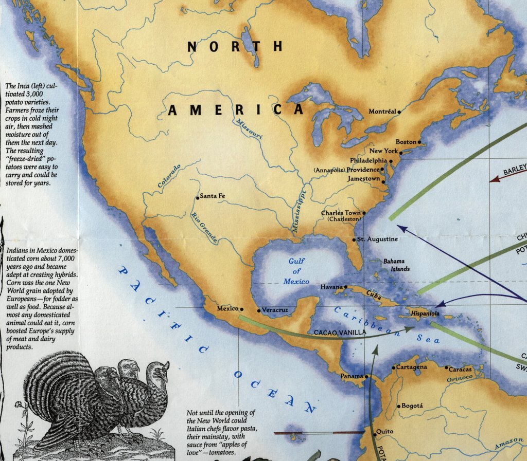
The "Map of the Month" for November 2006 in the Geospatial Center & Map Collection was a map titled Spain in the Americas, published by the National Geographic Society in 1992. The verso of the map "The Grand Exchange" was displayed due to its relationship to the Thanksgiving holiday. This side of the map shows the exchange of foods and other products between the Americas and Africa and Europe. The map mentions that turkeys were domesticated by the Aztecs and later became popular in Europe. The Pilgrims actually brought turkeys to America with them--only to find them living in the wilderness of New England. And "out of the myriad crops of the Americas, two--corn and potatoes--spread so widely that they became staples of human survival."

This map is available for checkout at the Geospatial Center & Map Collection.

November 2006 GCMC Events

November 2006 in the GCMC: What is GIS? Where is Congerville? and World War II

Students in Journalism 102 learned about what GIS is and how it is used in journalism and the media during a class presented by Angela Gibson from the Geospatial Center & Map Collection on November 13. Students in the Education Library 380/580 class learned about different types of maps and atlases, software, websites, and other resources during a class in the GCMC presented by Melissa Gentry on November 21. And Biology students learned about nautical charts in a special class project using maps from the GCMC.

Students from Industry and Technology: Construction Technology classes were provided digital aerial maps of campus for a class surveying project. A group of architecture students needed digital footprints of buildings in downtown Muncie. Another patron asked to view some of the aerial photgraphy of Indiana available in the GCMC to assess the implications of the proposed Indiana toll road in the local community.

Students from classes in geology, elementary education, geography travel and tourism, architecture, landscape architecture, historic preservation, communications, English, and music borrowed maps and atlases for various projects. One student was teaching elementary students about map projections, so she borrowed the Upside Down Map of the World to show a different perspective about making maps.

A World War II veteran used the services of the GCMC in November. The veteran was trying to find a map of the city of Reims in France, where he was stationed during the war. A copy of one of the maps was printed on the Center's large-format plotter. Another patron was planning an ambitious canoe trip and borrowed maps of Indiana rivers. And one researcher visited the Center trying to locate the village of Congerville in Delaware County--once the site of a professional football team, the Flyers.

Visit the GCMC Monday through Friday for GIS, maps, atlases, or to use the plotter printer. Contact the staff of the GCMC to schedule instructional sessions in the classroom or in the Center.

(The above photograph shows soldiers in World War II with a stockpile of maps. The photograph is from the Collection of Dennis Giangreco from the U.S. Army Atlas of the European Theater in World War II created by the U.S. Army Center of Military History and is available in the Atlas Collection of Bracken Library).

Thursday, November 30, 2006

New Maps in the Window

Just in Time for Holiday Shopping: Maps about Toys

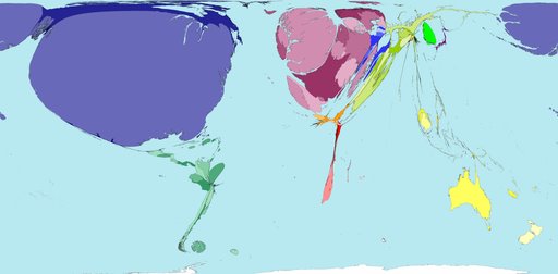
Maps showing toy exports and imports are on display in the windows of the Geospatial Center & Map Collection. These maps, however, are created in a unique format, and the resulting images can be extremely informative. The maps were printed from the World Mapper website at http://www.worldmapper.org. According to the site, "World Mapper is a collection of world maps, where territories are resized on each map according to the subject of interest." The scientists and cartographers of the World Mapper team input data to create these unique maps. For example, the above map shows countries with the greatest amount of toy imports. The United States appears large on this map, while Africa, South America, and Asia are nearly nonexistent. The map of toy exporting countries shows nearly the opposite effect.

Maps and information on the site are continually updated, with new topics regularly added. The project is supported by the University of Michigan, the University of Sheffield, the Leverhulme Trust, and the Geographical Association. The methods and data have built upon the work of Michael Gastner and the United Nations, supplier of much of the data.

Maps on the site are available in pdf poster format for printing. These maps serve as an excellent resource for researchers on a variety of topics. The maps are convenient for inclusion in research papers on a related topic or as a visual aid for a presentation. Some of the topics mapped on the site include: meat exports, steel imports, water use, forest loss, nuclear power, meat consumed, teenage mothers, female managers, child labor, undernourishment, girls not at primary school, adult literacy, and HIV prevalence. Some topics soon to be added include tuberculosis cases, malaria cases, and women and men smoking. The topics depicted on the maps are varied, and the data is very current, so the maps are extremely relevant.

Check out the World Mapper maps on display in the GCMC window or on the project website. Contact the staff of the GCMC for more information about using maps as resources in research papers or as visual aids for class presentations. The Center is open Monday through Friday from 8:00 A.M. to 5:00 P.M.

Google Earth in the GCMC

Google Earth: A Different View of the World

Google Earth is a program that shows satellite images and 3D overviews of major cities, mountains and other terrain, as well as business and travel information, streets, parks, and maps. A free version can be downloaded to desktops. Google Earth has been called "the democratization of satellite imagery," allowing millions of users to view places all over the world. Users can even tilt and rotate the view to see 3D terrain and buildings. Google Earth "puts the world's geographic information at your fingertips."

Since its introduction, millions of computer users have used Google Earth to view satellite images from all over the world. This new technology has created a fascination with some of the images that appear on Google Earth. A book available from popular booksellers is
Off the Map: The Most Amazing Sights on Earth as Seen by Satellite by James Turnbull and Alex Turnbull. This book includes unusual images that appear on Google Earth such as "Arizona's boneyard," the white snake of Baja," and "the hole in the coast of Mexico."

Users of Google Earth who discover interesting satellite images can also submit these sights to a website dedicated to the interesting views of the world, Google Sightseeing, which is located at www.googlesightseeing.com. (The site is not sponsored by or affiliated with Google). Submitters to this site have discovered hundreds of unusual sights in the satellite imagery, including dolphin-shaped islands, letter-shaped buildings, two different views of Aloha Stadium in Hawaii, and artistic shapes in the natural terrain. The image above is a satellite image of hills in Canada, but the submitter suggested a resemblance to a Native American listening to music on earphones.

Google Earth is available on all of the computers in the GIS lab of the Geospatial Center & Map Collection in Bracken Library. Visitors are welcome to use Google Earth in the lab to discover this new form of sightseeing.

Friday, November 17, 2006

Using Interlibrary Loan to Borrow Maps

Sharing Maps with Interlibrary Loan

University Libraries’ Interlibrary Loan service allows Ball State University faculty, staff, and students to borrow materials available at other libraries while users in other locations are able to borrow materials from University Libraries. Items may be located using CardCat, University Libraries’ catalog, and ILLiad, the Interlibrary Loan program.

Over the last seven years, the number of maps borrowed using Interlibrary Loan has increased five times. In 1999, 10 maps were borrowed from the Geospatial Center & Map Collection; last year 50 maps were borrowed through Interlibrary Loan by library users from other institutions. As more maps in the Collection are cataloged and accessed through CardCat, the number of maps borrowed through Interlibrary Loan is bound to increase. For example, the maps of the Middle East were cataloged in 2001 at the onset of the war in Afghanistan. Since that time, over thirty different maps of the Middle East have been shared through Interlibrary Loan, plus an entire set of topographic maps of Syria that were requested from the University of Notre Dame.

The list of institutions borrowing maps from the GCMC through Interlibrary Loan is diverse and geographically widespread. The University of Montana at Mansfield has become a regular customer, borrowing a number of different maps from the GCMC. The other four major Indiana colleges have also requested maps through Interlibrary Loan—Purdue University, the University of Notre Dame, Indiana University, and Indiana State University. Also, institutions with strong map collections have borrowed maps from the Collection at Ball State University: The University of Texas at Austin borrowed a 1683 map of Philadelphia and a map showing the world’s religions and missions. The University of Wisconsin at Madison borrowed a geologic tectonic map of the Caribbean from the GCMC.

Other institutions requesting maps from the GCMC: Vassar College, Brown University, George Washington University, Mississippi State University, University of Oregon, Savannah College of Art and Design, and the State University of New York at Oswego are some examples. The University of Arizona borrowed topographic maps of Arizona from the GCMC through Interlibrary Loan. Baruch College in New York, New York requested a 2000 bird’s-eye-view map of New York. The University of New Orleans used Interlibrary Loan to borrow a 1929 map of New Orleans that was in the Collection. And Golden West College in Huntington Beach, California and Lafayette College in Pennsylvania each borrowed the same map from the GCMC showing cultural activity and religions.

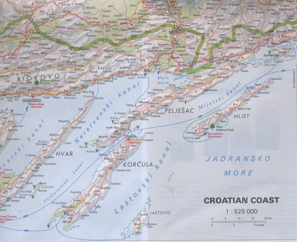
A number of government agencies have also requested maps from the GCMC via Interlibrary Loan. The Environmental Protection Agency in Chicago, through a recommendation of the GCMC Collection from Newberry Library, has borrowed maps on a couple of occasions. The office requested current and historic maps of Indiana highways, Elkhart, Muncie, and Terre Haute. The Environmental Protection Agency in New York also borrowed a map of the Capital district and Albany, New York from the GCMC. The U.S. Army Engineering Center in Alexandria, Virginia borrowed a 2002 map of the Croatian coast through Interlibrary Loan. The Wisconsin Department of Public Instruction in Madison borrowed a map of the Massif of Mt. Hubbard. And the National Imagery and Mapping Agency offices in Bethesda, Maryland and St. Louis, Missouri requested maps of the Ukraine and Lebanon from the GCMC.

Interlibrary Loan allows University Libraries to share materials with library users around the country, including academic libraries and public libraries. And the GCMC enjoys sharing maps from the Collection with other library users. To find out more about using Interlibrary Loan, please visit http://www.bsu.edu/library/collections/ill/ or contact the Interlibrary Loan office during regular business hours Monday through Friday at 765-285-1324.


Wednesday, November 15, 2006

Thanksgiving Break Hours

The Geospatial Center & Map Collection will be open regular hours (8:00 A.M. to 5:00 P.M.) on the first day of Thanksgiving Break, Wednesday, November 22. The GCMC will be closed on Thanksgiving Day and Friday, November 24.

GIS Display at the Indiana Statehouse

GIS Display at the Indiana Statehouse

The Indiana Geographic Information Council (IGIC) developed an interactive map of the state of Indiana called the IndianaMap. According to the IGIC website, "the IndianaMap includes the information people need most in a format that is accessible to both expert GIS users and the general public."

Starting today an exhibit about the project will be on display at the Indiana Statehouse. The exhibit featuring the IndianaMap serves to educate people on the use of the map and about GIS. The display "explains what GIS is, and shows how people in Indiana are using GIS to make our state a safer, healthier, and more profitable place to live." The IndianaMap display is located in the south atrium of the Statehouse from November 15-November 30.

The IndianaMap may be accessed at http://www.in.gov/igic/projects/indianamap/index.html

Tuesday, November 14, 2006

National Geography Awareness Week

Celebrating Africa

The National Geographic Society and others have been celebrating Geography Awareness Week since 1987, promoting the importance of geography. The theme for this year is "Celebrate Africa."

The National Geographic educational blog, My Wonderful World, (located at www.mywonderfulworld.org ) features various events and activities to mark the week, as well as lesson plans for educators and Africa resources.

The Geospatial Center & Map Collection is celebrating the week with a special display of Africa maps in the front windows of the Center. Photographs from National Geographic magazine, posters featuring movies about Africa, celebrities doing humanitarian work, and Africa music are included in the display.

The following maps from the GCMC are included: Africa, 1909; Road Map of Malawi; Casablanca; Moremi Wildlife Reserve; Somalia; Islam in Africa; Belgian Congo Mineral Deposits; Heritage of Africa; Africa, 1631; Nile River; Africa: Its Political Development.

Another display "Africa in the News" is also presented featuring a map of endangered species; a map of the destroyed villages in Darfur, Sudan; a poster about sports in Africa; an AIDS epidemic map; and several African news articles.

National Geography Awareness Week is November 12-November 18, 2006. Visit the second floor of Bracken Library to view these displays celebrating Africa.