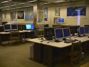
A View of the Geospatial Center & Map Collection
University Libraries Library Insider article, February 2005
Melissa Gentry, Map Collection Assistant, and Angela Gibson, Geographic Information Systems (GIS) Specialist, work with maps, data, and people, each in different ways. Both enjoy the interaction and diverse needs of serving students and faculty.
“Each person brings a new topic of study, so I feel like I am learning new things every day,” Melissa said. “ I enjoy seeing the different projects that the students are working on and being able to help them whenever I can,” Angie said. “It’s always satisfying to be able to ‘Wow!’ them by providing digital data that they didn’t know exists.”
Melissa says that many international students are surprised to find that the Center has a map of their hometown. Some professors assign projects where students are asked to use specific maps in the collection. For example, classes have used flood maps and historic maps of Muncie, maps showing the creation and changing boundaries of Israel, historic maps of Chicago’s lakefront, and topographic maps showing rivers. People use maps for site design in architecture and landscape architecture, for historical research, genealogy, and to use as visual aids in class presentations on various topics such as endangered species, climate, geology, disease, and religion. “A professor who had served in the Pacific during World War II was curious to find an island where he had been stationed,” Melissa said. “The island was off the coast of China but did not appear on any world or regional maps. The collection includes some World War II era maps that cover the world in quadrants, so the tiny island was found.” The professor said just finding the island gave him a sense of validation, and he shared some of his memories of his experiences during the war. Helping people in this way can be so rewarding.
In addition to assisting students, Melissa teaches classes about the Center’s resources. She also creates window displays using maps to cover topics of current events. Maps in the collection have been displayed to highlight various world events such as the wars in Afghanistan and Iraq, presidential election coverage, the Asian tsunami, the Olympics, sporting events, the creation of new countries, and displays commemorating Black History Month, Women’s History Month, and other celebrations. People enjoy looking at the window displays. “It’s good to know the people enjoy looking at the different maps!” she said.
Angie helps students plot posters and maps on the large format plotter. A large part of Angie’s day is spent helping students find digital GIS data for their projects and helping students with GIS software issues. During the past year, Angie created the digital thoroughfare GIS maps, which were used in a large scale transportation study for Delaware County. Angie also manages outreach efforts to raise awareness and inform faculty and students about the Geospatial Center’s resources and to encourage them to visit. Angie provides workshops to students, faculty and staff about GIS resources. She also maintains the unit’s Web page.

No comments:
Post a Comment