Thursday, November 30, 2006

New Maps in the Window

Just in Time for Holiday Shopping: Maps about Toys

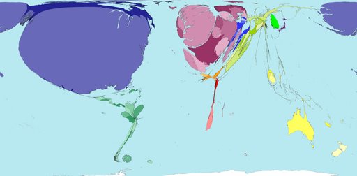
Maps showing toy exports and imports are on display in the windows of the Geospatial Center & Map Collection. These maps, however, are created in a unique format, and the resulting images can be extremely informative. The maps were printed from the World Mapper website at http://www.worldmapper.org. According to the site, "World Mapper is a collection of world maps, where territories are resized on each map according to the subject of interest." The scientists and cartographers of the World Mapper team input data to create these unique maps. For example, the above map shows countries with the greatest amount of toy imports. The United States appears large on this map, while Africa, South America, and Asia are nearly nonexistent. The map of toy exporting countries shows nearly the opposite effect.

Maps and information on the site are continually updated, with new topics regularly added. The project is supported by the University of Michigan, the University of Sheffield, the Leverhulme Trust, and the Geographical Association. The methods and data have built upon the work of Michael Gastner and the United Nations, supplier of much of the data.

Maps on the site are available in pdf poster format for printing. These maps serve as an excellent resource for researchers on a variety of topics. The maps are convenient for inclusion in research papers on a related topic or as a visual aid for a presentation. Some of the topics mapped on the site include: meat exports, steel imports, water use, forest loss, nuclear power, meat consumed, teenage mothers, female managers, child labor, undernourishment, girls not at primary school, adult literacy, and HIV prevalence. Some topics soon to be added include tuberculosis cases, malaria cases, and women and men smoking. The topics depicted on the maps are varied, and the data is very current, so the maps are extremely relevant.

Check out the World Mapper maps on display in the GCMC window or on the project website. Contact the staff of the GCMC for more information about using maps as resources in research papers or as visual aids for class presentations. The Center is open Monday through Friday from 8:00 A.M. to 5:00 P.M.

Google Earth in the GCMC

Google Earth: A Different View of the World

Google Earth is a program that shows satellite images and 3D overviews of major cities, mountains and other terrain, as well as business and travel information, streets, parks, and maps. A free version can be downloaded to desktops. Google Earth has been called "the democratization of satellite imagery," allowing millions of users to view places all over the world. Users can even tilt and rotate the view to see 3D terrain and buildings. Google Earth "puts the world's geographic information at your fingertips."

Since its introduction, millions of computer users have used Google Earth to view satellite images from all over the world. This new technology has created a fascination with some of the images that appear on Google Earth. A book available from popular booksellers is
Off the Map: The Most Amazing Sights on Earth as Seen by Satellite by James Turnbull and Alex Turnbull. This book includes unusual images that appear on Google Earth such as "Arizona's boneyard," the white snake of Baja," and "the hole in the coast of Mexico."

Users of Google Earth who discover interesting satellite images can also submit these sights to a website dedicated to the interesting views of the world, Google Sightseeing, which is located at www.googlesightseeing.com. (The site is not sponsored by or affiliated with Google). Submitters to this site have discovered hundreds of unusual sights in the satellite imagery, including dolphin-shaped islands, letter-shaped buildings, two different views of Aloha Stadium in Hawaii, and artistic shapes in the natural terrain. The image above is a satellite image of hills in Canada, but the submitter suggested a resemblance to a Native American listening to music on earphones.

Google Earth is available on all of the computers in the GIS lab of the Geospatial Center & Map Collection in Bracken Library. Visitors are welcome to use Google Earth in the lab to discover this new form of sightseeing.

Friday, November 17, 2006

Using Interlibrary Loan to Borrow Maps

Sharing Maps with Interlibrary Loan

University Libraries’ Interlibrary Loan service allows Ball State University faculty, staff, and students to borrow materials available at other libraries while users in other locations are able to borrow materials from University Libraries. Items may be located using CardCat, University Libraries’ catalog, and ILLiad, the Interlibrary Loan program.

Over the last seven years, the number of maps borrowed using Interlibrary Loan has increased five times. In 1999, 10 maps were borrowed from the Geospatial Center & Map Collection; last year 50 maps were borrowed through Interlibrary Loan by library users from other institutions. As more maps in the Collection are cataloged and accessed through CardCat, the number of maps borrowed through Interlibrary Loan is bound to increase. For example, the maps of the Middle East were cataloged in 2001 at the onset of the war in Afghanistan. Since that time, over thirty different maps of the Middle East have been shared through Interlibrary Loan, plus an entire set of topographic maps of Syria that were requested from the University of Notre Dame.

The list of institutions borrowing maps from the GCMC through Interlibrary Loan is diverse and geographically widespread. The University of Montana at Mansfield has become a regular customer, borrowing a number of different maps from the GCMC. The other four major Indiana colleges have also requested maps through Interlibrary Loan—Purdue University, the University of Notre Dame, Indiana University, and Indiana State University. Also, institutions with strong map collections have borrowed maps from the Collection at Ball State University: The University of Texas at Austin borrowed a 1683 map of Philadelphia and a map showing the world’s religions and missions. The University of Wisconsin at Madison borrowed a geologic tectonic map of the Caribbean from the GCMC.

Other institutions requesting maps from the GCMC: Vassar College, Brown University, George Washington University, Mississippi State University, University of Oregon, Savannah College of Art and Design, and the State University of New York at Oswego are some examples. The University of Arizona borrowed topographic maps of Arizona from the GCMC through Interlibrary Loan. Baruch College in New York, New York requested a 2000 bird’s-eye-view map of New York. The University of New Orleans used Interlibrary Loan to borrow a 1929 map of New Orleans that was in the Collection. And Golden West College in Huntington Beach, California and Lafayette College in Pennsylvania each borrowed the same map from the GCMC showing cultural activity and religions.

A number of government agencies have also requested maps from the GCMC via Interlibrary Loan. The Environmental Protection Agency in Chicago, through a recommendation of the GCMC Collection from Newberry Library, has borrowed maps on a couple of occasions. The office requested current and historic maps of Indiana highways, Elkhart, Muncie, and Terre Haute. The Environmental Protection Agency in New York also borrowed a map of the Capital district and Albany, New York from the GCMC. The U.S. Army Engineering Center in Alexandria, Virginia borrowed a 2002 map of the Croatian coast through Interlibrary Loan. The Wisconsin Department of Public Instruction in Madison borrowed a map of the Massif of Mt. Hubbard. And the National Imagery and Mapping Agency offices in Bethesda, Maryland and St. Louis, Missouri requested maps of the Ukraine and Lebanon from the GCMC.

Interlibrary Loan allows University Libraries to share materials with library users around the country, including academic libraries and public libraries. And the GCMC enjoys sharing maps from the Collection with other library users. To find out more about using Interlibrary Loan, please visit http://www.bsu.edu/library/collections/ill/ or contact the Interlibrary Loan office during regular business hours Monday through Friday at 765-285-1324.


Wednesday, November 15, 2006

Thanksgiving Break Hours

The Geospatial Center & Map Collection will be open regular hours (8:00 A.M. to 5:00 P.M.) on the first day of Thanksgiving Break, Wednesday, November 22. The GCMC will be closed on Thanksgiving Day and Friday, November 24.

GIS Display at the Indiana Statehouse

GIS Display at the Indiana Statehouse

The Indiana Geographic Information Council (IGIC) developed an interactive map of the state of Indiana called the IndianaMap. According to the IGIC website, "the IndianaMap includes the information people need most in a format that is accessible to both expert GIS users and the general public."

Starting today an exhibit about the project will be on display at the Indiana Statehouse. The exhibit featuring the IndianaMap serves to educate people on the use of the map and about GIS. The display "explains what GIS is, and shows how people in Indiana are using GIS to make our state a safer, healthier, and more profitable place to live." The IndianaMap display is located in the south atrium of the Statehouse from November 15-November 30.

The IndianaMap may be accessed at http://www.in.gov/igic/projects/indianamap/index.html

Tuesday, November 14, 2006

National Geography Awareness Week

Celebrating Africa

The National Geographic Society and others have been celebrating Geography Awareness Week since 1987, promoting the importance of geography. The theme for this year is "Celebrate Africa."

The National Geographic educational blog, My Wonderful World, (located at www.mywonderfulworld.org ) features various events and activities to mark the week, as well as lesson plans for educators and Africa resources.

The Geospatial Center & Map Collection is celebrating the week with a special display of Africa maps in the front windows of the Center. Photographs from National Geographic magazine, posters featuring movies about Africa, celebrities doing humanitarian work, and Africa music are included in the display.

The following maps from the GCMC are included: Africa, 1909; Road Map of Malawi; Casablanca; Moremi Wildlife Reserve; Somalia; Islam in Africa; Belgian Congo Mineral Deposits; Heritage of Africa; Africa, 1631; Nile River; Africa: Its Political Development.

Another display "Africa in the News" is also presented featuring a map of endangered species; a map of the destroyed villages in Darfur, Sudan; a poster about sports in Africa; an AIDS epidemic map; and several African news articles.

National Geography Awareness Week is November 12-November 18, 2006. Visit the second floor of Bracken Library to view these displays celebrating Africa.


Using GIS for Research

Geospatial Center & Map Collection GIS Workshop and Assistance Connects Researchers to Data for Project

University Libraries' Library Insider article by Angela Gibson, GIS Specialist

Two Ball State researchers are using services from the Libraries’ Geospatial Center and Map Collection (GCMC) to collaborate geographic datasets for their research project to learn more about the living and working experiences of former patients at Central State Hospital.

David Perkins, Ph.D., Department of Psychological Science, and Josh Raines, a graduate assistant in the Social Science Research Center, will use the versatile and powerful tools available by geographic information systems (GIS) to obtain special data which will help them research community conditions faced by former hospital inpatients.

More than 100 former patients are living at various locations in Marion County since the closure of the Indianapolis hospital. The researchers hypothesize that those individuals should live in neighborhoods distributed at random among the residential districts of a city rather than being clustered or
dispersed.

“The benefit of using GIS in this project is the way it adds systematic spatial and geographic details to the description and understanding of former inpatients' experiences of living in the community,” said Josh. “We were pleased that everything we needed seemed to be available at Ball State, including technical assistance from the University Libraries.”

Dr. Perkins learned about the SAVI website and its capabilities during a workshop called, “GIS Data: Finding Reliable GIS Data on the Web,” which was held by Angie Gibson, GIS Specialist in the University Library’s Geospatial Center and Map Collection. After the researchers attended the GIS workshop, they contacted Angie at various times for assistanceduring the research project.

The two researchers geocoded a list of former patients’ addresses, along with United States census indicators and information from the Social Assets and Vulnerabilities Indicators, www.savi.org. Angie helped them during the geocoding process and showed them how to join the geocoded address points to the census tract layer to establish census tract numbers for all the address points.

Geocoding is a GIS operation for converting street addresses into spatial data that can be displayed as features on a map, usually by referencing address information from a street segment data layer.

Other spatial variables, such as crime rates, accessibility of parks, libraries and other community resources, can be added to the database. This geographic information will be combined with other data on the persons in recovery, including psychiatric services they were receiving, whether they were working, and ratings of recovery made by their primary therapists and will examine how the particular census tracts compare with Marion County as a whole in terms of social disorganization, transience, and the percentage of persons having disabilities.

Thursday, November 02, 2006

October 2006 Map Displays


In the Window: October 2006 GCMC Map Displays

The "Map of the Month" for October was chosen to commemorate the Columbus Day holiday. Two copies of the Architectural Tour Map of Columbus, Indiana, were displayed. One side of the map shows the route of the architectural tours hosted by the Columbus Visitors Center, and the other side of the map displays photographs of buildings featured on the tour and information about the designs and architects. (The building shown is the First Christian Church, which was designed by Eliel Saarinen). The two maps were recently donated to the GCMC and update an earlier version of the map in the Collection.

Other maps displayed during October included Indiana's Haunted Hometowns, Indiana's Congressional Districts Map, a map of Baghdad and other maps related to news events.

Please visit the Geospatial Center & Map Collection in Bracken Library to view the map displays. Contact the Center if you would like to donate maps to the Collection.

Wednesday, November 01, 2006

October 2006 GCMC Activities

October Comings and Goings in the GCMC

The Geospatial Center & Map Collection hosted six tour groups during the month of October. Three classes of Creative Writing, one Honors College class, and one English 104 class visited the Center to learn about the resources available. Another tour group included first-year instructors at the University. The visitors learned about how to print a poster for a presentation using the large-format plotter and how to use GIS for class assignments or papers in the GIS lab. The students and staff also learned about using maps as visual aids in speeches or in research papers. The students in the Creative Writing classes were surprised to find maps of fictional locations, maps of the settings for Shakespeare's plays, and even a map of Springfield from the television show The Simpsons included in the Collection.

Other classes also visited the GCMC as part of an assignment: Geography 150 and 353 students were given an assignment to use specific map sets from the Center to improve their map-reading skills. The students wrote papers about the development of a city of their choice using topographic maps, street maps, and historic bird's-eye views. Physical Education: Professional 155 students were given an assignment to use the Center's GIS lab to create and print a poster for a class presentation.

Also in October, the GIS Specialist worked with a graduate assistant from the Department of Anthropology creating a map about an archaeological site for a presentation. The historic route of the Mississinewa River was mapped and buffers were added at incremental distances using GIS software.

The Ukraine seemed to be a popular country for researchers in the GCMC during October. One patron used maps of the Ukraine to find the cities of Lvov and Dashava, which were mentioned in letters from a soldier to the patron's grandmother during World War II. Another patron borrowed maps of the Ukraine for an upcoming presentation about her volunteer activities in the country as a member of the Peace Corps, and, coincidentally, another patron wanted to review maps of the Ukraine since she will soon be living there teaching English as a Peace Corps volunteer.

Please visit or contact the GCMC for assistance with class assignments, posters, and presentations, or to take a tour. The Center is open Monday through Friday from 8:00 A.M. to 5:00 P.M. Contact the Center at (765) 285-1097.