Monday, December 23, 2013

Holiday Hours at Ball State University Libraries


GIS Research and Map Collection Holiday Hours

The Ball State University Libraries' GIS Research and Map Collection will close today (December 23) at 3:00 pm and reopen on Thursday, December 26 at 8:00 am resuming regular hours until 5:00 pm.  The GRMC will close on Tuesday, December 31 at 3:00 pm and reopen on Thursday, January 2 at 8:00 am.

Please contact the GRMC at 765-285-1097.

News Maps Available from Ball State University Libraries

Syria

Washington, D.C.

 Healthcare coverage

South Africa

Russia

Tornadoes

Boston, Massachusetts

Tahrir Square, Cairo, Egypt

Vatican City

North Korea

London, England

2013 Places in the News:  Mapping Current Events with Maps from the GIS Research and Map Collection


The Ball State University Libraries’ GIS Research and Map Collection (GRMC) exhibits maps of places in the news in the front windows on the second floor of Bracken Library and digitally through the Blog.  The places in the news for 2013 have featured war, violence, and natural disasters from Syria to Moore, Oklahoma.  Political issues dominated the news—from intelligence and national security issues to healthcare coverage.  However, some good news events marked the year in maps—from the birth of an heir to the throne in London, England, to a new Pope elected in Vatican City in March.

These maps are just some of the nearly 140,000 maps, atlases, and other cartographic resources available from the GRMC.  Maps circulate for two weeks or longer and can be an effective research and presentation tool.

For more information, please contact the GRMC at 765-285-1097.


Friday, December 06, 2013

Indiana History Maps Available from Ball State University Libraries


Horsepower to Hysteria:  Map Exhibit Celebrates Indiana Sports History

Indiana was admitted to the Union in December 1816, so the “Map of the Month” exhibit in the front windows of the Ball State University Libraries’ GIS Research and Map Collection (GRMC) is Horsepower to Hysteria:  Indiana Sports History.  The map features great figures, events, and places in the sports history of Indiana.

The map identifies the hometowns of sports legends like John Wooden, Bob Griese, Larry Bird, Oscar Robertson, Marshall Taylor, and even the world’s fastest pacer horse, Dan Patch.  Legendary teams like the Milan basketball team depicted in the movie “Hoosiers” is featured as well as historic events like the Indianapolis 500 and the tragic Purdue football team train wreck in 1903.

The map is part of a series of Indiana maps created by the GRMC commemorating the state’s rich history and culture.  The Indiana maps are available for use in the classroom or for printing from the Cardinal Scholar DigitalRepository.  Photographs from numerous collections in the Ball State University Libraries’ Digital Media Repository are also featured.

For more information, please contact the GRMC at 765-285-1097.


Monday, November 25, 2013

End-of-Semester Printing and GIS Project Information


FAQ: “How Do I Print a Large Poster?”  “How Do I Connect to Ball State University Libraries’ GIS Data Server?”

Students are completing many final projects and homework assignments for the fall semester.  Often students must create presentations or large posters as a final project.  The Ball State University Libraries GIS Research and Map Collection (GRMC) has two large-format plotter printers available for use by members of the Ball State University community.

“How do I print a large poster?  How long does it take?  How much does it cost?”  Students can create a poster using a slide designed in Microsoft PowerPoint.  A guide explaining how to design a classroom or conference poster is available in Cardinal Scholar. 

A poster usually takes about fifteen minutes to print, but if many people are printing at the same time, the wait time will be longer.  Students and staff are charged for printing through their Bursar’s account, with the cost dependent on the size of the poster.  Printing on the plotters is available Monday through Friday from 8:00 a.m. to 4:00 p.m. 

One of the most frequently asked questions in the GRMC arises from students trying to access the Libraries’ GIS Data Server in order to complete a GIS homework assignment or special project.

Members of the Ball State University community can access this data by entering user names and passwords if not already logged in to the Ball State University network: 

  • In order to map a network drive, click on the Start button; right-click "Computer;" then click "Explore."
  • In the Tools menu or on the Graphical User Interface (GUI), click "Map Network Drive."
  • In the Drive box, click the drive letter "L."  (Note: By default ArcGIS Desktop uses full path names. Always map data to the same letter drive in order to avoid having to repair the data source when opening a map document).
  • In the Folder box, type \\libgis\data.  (If not logged in to the BSU network, a BSU user name and password will be needed to access this data).
The data on this server is read-only, so needed datasets must be copied and pasted (using ArcCatalog) to an iLocker folder or a USB drive.  Also, the data on the server was provided by the Delaware and Henry County GIS Departments and must be used for education and research purposes only and may not be provided to third parties.

A tutorial with screenshots explaining how to map to the GIS Data Server is available on the GRMC Webpage.  For more information about using GIS, please contact Angela Gibson, GIS Specialist, at 765-285-1097.


Friday, November 22, 2013

GIS Map of the Life of President John F. Kennedy


ESRI GIS Map and Video Depicts the Life of John F. Kennedy

On the 50th anniversary of the assassination of John F. Kennedy, leading GIS software developer ESRI has created an interactive story map of the major events in the life of the former president.  “Even though he was only President for three years, John F. Kennedy has become one of the most iconic individuals in American history."

Users can take a geographic tour of key moments in Kennedy’s life, from his birth in Brookline, Massachusetts, through his early travels in Europe, his tour of duty during World War II with the U.S. Navy, to his speech at the Berlin Wall, to his assassination in Dallas, Texas.  The map also features videos of famous speeches and how the geography of Dealey Plaza affected the events on November 22, 1963.  The map and video may also be embedded in other Web sites.

For more information about using story maps, visit the ESRI Web page or the Storytelling with Maps gallery.

(Photograph above shows candidate John Kennedy visiting  Muncie, Indiana, in 1960 and is from the Ball State University Libraries' Archives and Special Collections.  All rights reserved).

Tuesday, November 19, 2013

Gettysburg Maps Available from Ball State University Libraries


“Four Score and Seven Years Ago…” 
Gettysburg Maps Available from Ball State University Libraries

The National Park Service is commemorating the 150th anniversary of the Gettysburg Address with special events at the Gettysburg National Military Park on November 16-23.  President Lincoln delivered the famous address—which defined the meaning of the war—on November 19, 1863 at the dedication of a cemetery.

The Ball State University Libraries’ GIS Research and Map Collection (GRMC) on the second floor of Bracken Library includes various maps of Gettysburg, Pennsylvania.  A National Geographic map, 1863: Turning Point of the Civil War, shows the movements of two infantry regiments between Chancellorsville and Gettysburg.

Gettysburg, Pennsylvania: Illustrated Gettysburg Battlefield Map and Story (top above, click to enlarge) was published in 1959 and includes Civil War troops’ movements and positions.  The map also includes several points of interest.

The map, Gettysburg Battlefield, (bottom map above) was published by McElfresh Map Company in 1994.  This set of maps includes depictions of the first, second and third days’ battlefield and are printed reproductions of watercolor originals.  The maps include land use, vegetation cover, field crops, field lines, and farmers’ names as in 1863.

The map, Gettysburg Invasion and Retreat, was published as a part of the Maryland Civil War trails series and is a regional tourist map showing Civil War-related points of interest and recommended highway tours in five Maryland counties and adjacent parts of Pennsylvania.

The Maps of Gettysburg: An Atlas of the Gettysburg Campaign, June 3-July 13, 1863 was published in 2007 and is available from the Atlas Collection.  The atlas includes 144 full-page color enhanced maps that cover the advance, battle, and retreat.

Maps from the GRMC circulate for two weeks or longer.  Atlases circulate for 28 days. 

For more information about these maps or other cartographic resources, please contact Melissa Gentry in the GRMC at 765-285-1097.


Monday, November 18, 2013

Ball State University Immersive Learning Project Speaker at Bracken Library


The Lenape on the Wapahani River:  Friends of Bracken Library Program November 19 at Ball State University Libraries

Christopher Flook, Instructor in the Ball State University Department of Telecommunications, will present a program “The Lenape on the Wapahani River” for the Friends of Alexander M. Bracken Library on Tuesday, November 19 at 7:30 p.m. in Bracken Library room 104.  Flook and students Kayla Eiler and Alina Beteringhe will detail the history of Native Americans who settled along the White River and the documentary film being created as an immersive learning project.

The event is free and open to the public. Free parking is available in the Emens parking structure next to Bracken Library after 7:00 p.m.  For more information, please contact John Straw at 765-285-5078 or jstraw@bsu.edu.  

Friday, November 15, 2013

Ball State University Libraries' GIS Research and Map Collection Offers Community Maps Class


The History Geography Maps Class at Cornerstone Center for the Arts November 18

The Ball State University Libraries’ GIS Research and Map Collection (GRMC) will be presenting a class for the community featuring maps from the collection.  The class will be held at the Cornerstone Center for the Arts (520 East Main, Muncie) on November 18 at 6:00.

Muncie’s Maps: A Hidden History will explore the history of the city of Muncie and the state of Indiana using maps from the GRMC.  More than just cartographic resources, maps can shed light on the history, economy, and culture of a place.  Historic maps will show the evolution of the city from a Native American village on the White River to a metropolitan city during the Gas Boom to an industrial center to the diverse city of today.

For more information about the class, visit the Cornerstone Web page or call Carly Acree King, Director of Education and Communication, at 765-281-9503.  Contact Melissa Gentry in the GRMC at 765-285-1097.  

Wednesday, November 06, 2013

Native American Heritage Month Map Exhibit at Ball State University Libraries


Native American Heritage Month Maps Exhibit

The Ball State University Libraries’ GIS Research and Map Collection (GRMC) is commemorating Native American Heritage Month with a special exhibit in Bracken Library.  The exhibit features maps and photographs from The Historical Atlas of Native Americans by Ian Barnes, which is available in the GRMC and Atlas Collection on the second floor of Bracken Library.

The maps include depictions of the ancient Native American culture and trade areas, Pontiac’s and Tecumseh’s Wars, Chief Joseph’s retreat, Indian wars in the west from 1850-1900, and Native American resettlement areas.  Photographs include prominent figures in Native American history—Sitting Bull, Sarah Winnemucca, Ely Samuel Ponder, Osceola, Gertrude Simmons Bonnin, and Tecumseh.  Other photographs show Oglala warriors on the Pine Ridge Indian Reservation in South Dakota in 1908 and Comanche code talkers from World War II.

The exhibit is available in PDF-format from the Ball State University Libraries’ Cardinal Scholar.  Teachers and others may print off a copy of the exhibit for use in the classroom or other projects and displays for research and learning.

This exhibit is located in the front windows of the GRMC on the second floor of Bracken Library and will be available through the month of November. 

For more information about these cartographic resources, please contact the GRMC at 765-285-1097.

Tuesday, November 05, 2013

Ball State University Celebrates GIS Day November 20


Ball State University GIS Day November 20, 2013

GIS Day is celebrated this year on Wednesday, November 20.  The Ball State University GIS Knowledge Group will be hosting an event in Bracken Library in the Schwartz Complex and Bracken Library room 104 located just off the lobby from 11 a.m. to 2 p.m.

Visitors can learn about GIS resources on campus, watch brief presentations from faculty, students, and staff describing class and research projects incorporating GIS methods, and view posters created by GIS users around campus.  A poster and presentation competition will award prizes to participants showcasing their work.

Presentations begin at 11 through noon.  The poster competition begins at noon, and users can browse information about GIS software and data resources on campus and participate in a question and answer session with the GIS Knowledge Group at this time.  More presentations will be held from 1 to 2 p.m.

Faculty, staff, and students interested in presenting one of the five-minute overviews about class or research GIS projects can contact Angela Gibson to reserve a block of time for the presentation at asgibson2@bsu.edu

GIS users wishing to create a GIS project poster for the competition may print posters free of charge in the Cooper Science GIS lab.  Contact Zaine Venter for information about printing at zventer@bsu.edu

This event is free and open to the public.  Anyone interested in GIS technology is invited to participate, view the posters and presentations, and vote for the best GIS projects.  For more information, please contact the Ball State University Libraries’ GIS Research and Map Collection at 765-285-1097. 

Tuesday, October 15, 2013

GIS Day Events


Indiana GIS Day and Conference Set for November 5, 2013

From Indiana Geographic Information Council Newsletter

Explore the innovative ways GIS is used to improve government operations.  GIS has the unique capability to help explain large amounts of information via maps and graphics using location information.  Cross-agency applications appear seamless when data is merged into a GIS.  See and learn the many new avenues for using this increasingly important technology.

The Indiana GIS Day and Conference will be held at the Indiana Government Center South Conference Center at 402 West Washington Street in Indianapolis on Tuesday, November 5 from 8:30 am to 3:00 pm.  Registration is free.  Anyone who plans, manages, or performs any geospatial activities will benefit from attending this event.  Presentations and resources are for GIS users at all levels of experience and include Arc Hydro:  GIS for Water Resources, How to Unlock the GIS Data Vault, When Good Maps Go Bad (Cartography), and How to Preserve and Integrate Historic Sanborn Maps in Your GIS.  Pre-registration is required.

The Ball State University Libraries’ GIS Research and Map Collection (GRMC) will be hosting GIS Day in Bracken Library from 11:00 am to 2:00 pm on Wednesday, November 20.  This event will feature learning sessions and a poster display.

For more information, please contact Jim Sparks, Indiana Geographic Information Officer, at 317-234-5889 or Angela Gibson, Ball State University Libraries GIS Specialist, at 765-285-1097.  A full agenda is available on the Indiana Geographic Information Council Web page.

Monday, October 14, 2013

Cuban Missile Crisis Maps from Ball State University Libraries


Thirteen Days in October:  Mapping the Cuban Missile Crisis

Today, October 14, marks the day in 1962 when United States photographic intelligence revealed evidence of nuclear missile—medium-range (MRBM) and intermediate-range (IRBM)—sites in Cuba delivered from the Soviet Union.  The date marks the anniversary of what became known as the “Cuban Missile Crisis” as President Kennedy set up a blockade of Soviet ships to Cuba and considered attacking Cuba if the missile sites were not dismantled and returned to the Soviet Union.

The maps above (click to enlarge) depict the geography of the world on the brink of nuclear war.  The top map is from the Palgrave Concise Atlas of the Cold War published in 2003.  The map shows the area of the United States and other countries that were threatened by Soviet missiles launched from Cuba.  The map also shows the area covered by U.S. air patrols and key military bases, including one at Guantanamo Bay, Cuba.

The second map is from the Historical Atlas of the United States also published in 2003.  This map shows the supply route and Soviet ports used to deliver the missiles to Cuba.  The countries in blue represent NATO and U.S. allies, while the peach color represents countries allied with the Soviet Union and the Warsaw Pact.  Concentric circles show the ranges of intermediate-range and medium-range missiles launched from Cuba.

The atlases are available from the Atlas Collection on the second floor of Bracken Library.  Atlases circulate from the library for 28 days or longer, and the maps can easily be scanned for use in papers, presentations, and other research and learning.

For more information, please contact the GIS Research and Map Collection at 765-285-1097.


Thursday, October 10, 2013

Exploration Maps Available at Ball State University Libraries


Columbus Day:  Mapping Where Christopher Columbus Discovered America

The Ball State University Libraries’ GIS Research and Map Collection (GRMC) on the second floor of Bracken Library includes a collection of maps and atlases depicting the routes of European explorers. 

The map above (click to enlarge) shows the routes of Christopher Columbus’ journeys between Spain and the Caribbean.  The map was published by the National Geographic Society in 1986 and identified new evidence that marked Columbus’ landfall at Samana Cay, a large uninhabited island in the Bahamas.

Another map from the National Geographic Society, The Explorers, shows the voyages and travels of explorers beginning in A.D. 100 through the 1900’s and includes the exploration of the Arctic and Antarctica.

Historical Atlas of Exploration: 1492-1600 and Atlas of Exploration are also available from the Atlas Collection.  These atlases include maps and charts about the great discoveries in geography and mapping.

Maps from the GRMC circulate for two weeks or longer, and atlases circulate for 28 days or longer.

For more information, please contact the GRMC at 765-285-1097.

Thursday, September 26, 2013


Leaf View:  Online Fall Foliage Maps

Travelers searching for the best fall colors can access fall foliage maps on The Weather Channel Web page.  Maps are divided in nine regions, showing peak times or users can click on an individual state from the list.  The maps are updated daily and list conditions as patchy, near peak, peak, and past peak.  Most of the maps currently show no change:  “Only occasional patches of color, not fully developed.  The predominant color is still green.” 

The Brown County Indiana “Leaf Cam” is also now available online.  The camera is mounted high above one of the overlooks of the county so viewers can watch the changing of the leaves.  Typically the peak time for change in Brown County is the second or third week of October, but weather affects the times of the changing colors.


Friday, September 20, 2013

Hispanic Heritage Month, September 15, 2013


Hispanic Heritage Month Map Exhibit at Ball State University Libraries' GIS Research and Map Collection

The Ball State University Libraries' GIS Research and Map Collection (GRMC) is commemorating Hispanic Heritage Month with a special map exhibit.  The exhibit includes maps, charts, and photographs from The Atlas of Hispanic-American History from the Atlas Collection on the second floor of Bracken Library.  Included are maps of the attack on the Alamo, the California mission system, New Spain, and styles of Latin music.  Charts and photographs also describe Cesar Chavez and the United Farm Workers Movement.

The exhibit is posted in the front windows of the GRMC on the second floor of Bracken Library through October 15.  The Atlas of Hispanic-American History is available for circulation from the Atlas Collection.

For more information, please contact the GRMC at 765-285-1097.

Monday, September 16, 2013

Washington Navy Yard Maps


Maps of Washington, D.C. and Washington Navy Yard from Ball State University Libraries

The Ball State University Libraries' GIS Research and Map Collection (GRMC) includes a large collection of maps of Washington, D.C. and the surrounding area.  The top map shows the location of the Washington Navy Yard in the top right corner (click to enlarge).  This United States Geological Survey topographic maps shows the location compared to Washington National Airport, the Pentagon, and Arlington National Cemetery.  The second map was published by H.M. Gousha and includes updated roads and tunnels.

For more information, please contact the GRMC at 765-285-1097.

Wednesday, September 04, 2013

Syria Maps Available from Ball State University Libraries


Maps in the News: Syria

The Ball State University Libraries’ GIS Research and Map Collection (GRMC) has a significant collection of maps of Syria and the Middle East.  The maps include both historic maps of the country and the region and new, updated maps.

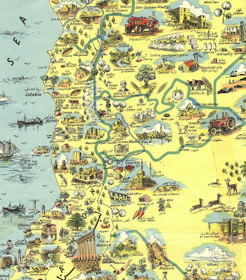
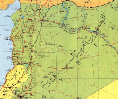
The image shown above (top, click to enlarge) is from a historic pictorial map of Syria from 1943 called “Illustrated Syria.”  The map depicts agricultural and industrial products and places of interest, including parts of Jordan, Iraq, Lebanon, and then Palestine.  An inset map shows main roads, air routes, railroads, pipelines, and political divisions.  The map text is written in English and Arabic.

Other maps of Syria in the collection include tourist maps, maps of archaeological sites, road maps with images of sites of interest, economic activity maps, and land use and population maps.  A unique tectonic sketch map showing oil wells and petroleum exploration from 1978 was produced by the Foreign Scouting Service.  Four sets of topographic maps of Syria at varying scales are also available.  Newer maps showing administrative divisions and relief show the changing borders of the region, and many of the maps include the Golan Heights.  City maps of Syria are also featured in the collection, including a reproduction of a bird’s eye view map of Damascus from 1575.

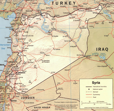
The most up-to-date maps of Syria are published by the Central Intelligence Agency (CIA), and the GRMC includes hundreds of political and physical maps in this collection.  The collection of CIA maps is also available online in the Digital Media Repository.  The Ball State University Libraries’ Digital Media Repository provides online access to a variety of primary source materials and cartographic resources.  This collection, Maps of the World, provides digital maps of nearly 200 regional and national maps.  These public domain maps reflect the most current changes in national borders and territories.

The Atlas Collection on the second floor of Bracken Library also includes resources on Syria and the Middle East.  The Historical Atlas of Syria and the Lonely Planet Atlas of Jordan, Syria, and Lebanon are available for circulation for one month or longer.

Maps from the GRMC circulate for two weeks or longer.

For more information, please contact the GRMC at 765-285-1097.


Tuesday, August 27, 2013

Cartographic Wildfire Resources at Ball State University Libraries


Maps in the News:  GIS Wildfire Tracking, Maps of Yosemite National Park Available in the GIS Research and Map Collection

The Rim Fire is blazing in the northern side of Yosemite National Park.  So far the fire has destroyed about 280 square miles of forest and is less than ten miles from the giant sequoias.  Researchers can access dozens of maps of the park in the Ball State University Libraries’ GIS Research and Map Collection (GRMC) on the second floor of Bracken Library.

The GRMC includes a map of the park and the surrounding wilderness published in 2007.  This map is created with relief shown by contours and shading.  Six bird’s-eye views and a map of “Yosemite creek past and present” are also included.  The verso of the map tells the geologic “story” of Yosemite Valley.

Another interesting map of the national park is Satellite Orthoimage of Yosemite Valley, Yosemite National Park, California.  This map of the area was created from satellite images.  Map of Yosemite Region is another map in the GRMC that includes a table of campground information.  Maps of Yosemite Valley, Yosemite National Park, Mariposa, Bass Lake, the Sierra National Forest, and many other lakes and recreation areas are also included.

The historic map above of Yosemite National Park (top, click to enlarge) was published in 1949 by the U.S. Department of the Interior and the National Park Service and shows the locations of creeks, lakes, and mountains.  The Hetch Hetchy Reservoir—the water resource for the city of San Francisco—can be viewed on the left side of the map.
 
Current topographic maps of the park are also available in the GRMC, and many road maps of the state of California include inset maps of Yosemite.  An official guide map of Yosemite National Park dated from 1931 is also included in the Collection, and includes a map of the Yosemite Valley (above).

Maps from the GRMC circulate for two weeks or longer.

ESRI, the GIS software development company, has created an interactive map of wildfire locations in the United States called the PublicInformation Map.  Users can view real-time social network updates while viewing maps of wildfires and potential fire areas.

Please contact the GRMC for more information Monday through Friday from 8:00 to 5:00 at 765-285-1097.

Ball State University Libraries' March on Washington Map


March on Washington:  Washington, D.C. Map Marks 50th Anniversary of Dr. Martin Luther King, Jr.’s “I Have a Dream” Speech


Tomorrow, August 28, marks the anniversary of the March on Washington for Jobs and Freedom.  The March on Washington was one of the largest political rallies in United States history, and took place in Washington, D.C. on August 28, 1963.  Dr. Martin Luther King, Jr. delivered his historic “I Have a Dream” speech at the Lincoln Memorial in front of an estimated 300,000 participants.

Ball State University Libraries’ GIS Research and Map Collection (GRMC) is commemorating this historic anniversary with a special “Map of the Month.”  The U.S. Geological Survey Earth Resources Observation and Sciences Center published this aerial map of Washington, D.C. (above, click to enlarge).  The ortho-imagery was captured in April of 2010 and published in April 2012. 

The verso of the map, Changing Waterways of Our Nation’s Capital, shows the original plan of Washington with canals developed for transportation.  Five different maps show how the waterways have diminished over time due to development and the influx of sediment.

Maps from the GRMC circulate for two weeks or longer.  For more information, please contact the GRMC at 765-285-1097 Monday through Friday.

Friday, August 23, 2013

Ball State Campus Map App Available for Smart Phones


Ball State University Campus Map App Available for Smart Phones

From Ball State Communications Center:

Students, faculty, and visitors to the campus of Ball State University can use an iPhone or Android app developed by the University.  The Campus Map App features an interactive map highlighting campus buildings, departments and computer labs.  The app also shows the locations of parking lots and dining facilities, notable landmarks, bike racks, and ATM’s.  

The app can also create custom directions.  Plus the Ball State Campus Map App features live bus tracking.

The Ball State Campus Map App is available free to download in the iTunes App Store and Google Play Store.

Friday, August 16, 2013

Back-to-School Resources from Ball State University Libraries


Cartography in the Classroom:  Back-to-School Resources from the GIS Research and Map Collection

Teachers and students from elementary school to the college classroom can access important classroom resources created by the Ball State University Libraries’ GIS Research and Map Collection (GRMC) from the Cardinal Scholar institutional repository.  Cardinal Scholar allows users to access invaluable resources from any location with Web access.

Teachers and student teachers headed back to the classroom can find numerous games, posters, lesson plans, map worksheets, map and GIS tutorials, and other resources in Cardinal Scholar.  These classroom resources were developed for K-12 teachers and can be browsed by clicking “Communities and Collections” on the left side of the Cardinal Scholar homepage; then scroll down to “Information Technology” and click on “GIS Research and Map Collection” listed under the University Libraries section.  Then choose “browse by title” to see the list of the hundreds of resources available from the GRMC.

Users may also browse by topic from the main Cardinal Scholar homepage.  For example, type “Africa map,” and this search provides a list of maps, posters, and tutorials related to the geography of Africa.

The GRMC is continually developing maps, lesson plans, tutorials, and other resources for use from Cardinal Scholar, so students and teachers should check Cardinal Scholar or the GRMC news Blog regularly for updates.  A new collection of maps focusing on the study of Indiana history (Indiana sports history map above, click to enlarge) is an example of some of the updated resources available for research and learning.  These maps can be used by teachers for lessons in the classroom or for exhibit on bulletin boards.

Students and other researchers writing papers or preparing presentations may consider using maps from the GRMC or the Atlas Collection as visual aids to add interest and impact.  These collections include maps and other cartographic images that visually depict numerous current issues.  An online guide, Using Maps and Atlases as Resources for Papers,Posters, and Presentations, details how cartographic images can enhance research.

Students, professors, or conference speakers needing to create a presentation poster can also use a guide from Cardinal Scholar explaining how to create a poster using PowerPoint software.  The GRMC provides two large plotter printers available to the Ball State community for printing large posters, maps, and other documents.  A large laminator is also available in the GRMC.  Users are charged through their Bursar account for printing and laminating.

The staff of the GRMC is also available for classroom instruction sessions or assistance with class projects.  Maps from the GRMC can also be borrowed for use in the classroom for as long as a semester.

For more information about using these resources or finding other materials available from Cardinal Scholar, please contact the GRMC Monday through Friday at 765-285-1097. 


Thursday, August 15, 2013

Egypt Maps Available from Ball State University Libraries


Maps in the News:  Egypt

The Ball State University Libraries’ GIS Research and Map Collection (GRMC) in Bracken Library includes a large collection of maps of Egypt.  The collection includes hundreds of maps of Egypt today, Egypt as a part of the United Arab Republic from 1958 through 1971, regions, cities, the Suez Canal, nautical charts, topographic maps, and numerous other cartographic resources.

The GRMC has a copy of the Gizi Map 2007 map of Egypt that shows roads and physical topography.  This map is published in English, Arabic, German, and French.  The International Travel Map of Egypt published in 2002 includes inset maps of the Giza pyramids and the inter-city rail service.

The GRMC collection of Egypt topographic maps were published by the Army Map Service and Defense Mapping Agency and are available in three different scales.  The nautical charts published in 2004 detail the areas of Egypt along the coast.  Maps of the ancient civilization of Egypt are also available in the GRMC.

The collection of Egyptian city maps is extensive and includes maps of Cairo dating back to 1920.  The set of Cairo maps also includes a map of Tahrir Square (above, click to enlarge).  A rare map of Luxor from 1933 is also included in the GRMC.  Other city maps available are Alexandria, Damanhur, Damietta (Dumyat), El-Qantarah el-Shargiyya, Ismailia, Minya, Tanta, and Suez.  A map of the Suez Canal is also available in the GRMC. 

Maps of Egypt are also available in the University Libraries’ Digital Media Repository and a map poster (above) created by the GRMC can be accessed from the Cardinal Scholar repository.  All maps in the GRMC may be circulated for two weeks or longer.

The entire collection of maps of Egypt are not cataloged and cannot be accessed using the University Libraries’ CardCat system.  Researchers can visit or contact the GRMC to view the entire collection or contact Melissa Gentry.