Friday, June 27, 2008

Zimbabwe Maps in the Ball State University Libraries


Maps in the News: Un-cataloged Maps of Zimbabwe in the GRMC

The violence surrounding the elections in Zimbabwe has been widely covered on the news. The Geospatial Resources & Map Collection on the second floor of Bracken Library has several maps of Zimbabwe available for those interested in learning about this country in southern Africa.

A 2002 travel map of Zimbabwe and several basic maps produced by the Central Intelligence Agency are available in the ready-reference area of the GRMC. These maps have been cataloged and can be viewed in the University Libraries’ CardCat online catalog. However, the GRMC also has many maps of Zimbabwe that are not listed in the catalog. There are also maps of the country featuring its former names, Southern Rhodesia, Zimbabwe Rhodesia, Rhodesia, and the Federation of Rhodesia and Nyasaland.

Many maps of Zimbabwe in the GRMC would be excellent for studying the climate, physical features, and industry of the country. The Collection features a map of the average rainfall of Southern Rhodesia, a physical map of Zimbabwe, a map of the minerals of Zimbabwe, a map of gold mines in the country, and a soil map of Zimbabwe Rhodesia.

The GRMC has maps of Zimbabwe showing tribal trust lands, the location of tribes and languages shortly after independence, a map showing the African and European population distribution of the country in 1969, and maps showing the percentages of Ndebele and Shona speakers by district.

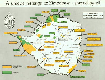
Several beautiful tourist maps of Zimbabwe and Rhodesia are included in the GRMC. There are also maps of the national parks and a gazetteer road map of the Federation of Rhodesia and Nyasaland. Regional maps including Zambia and Malawi, and city maps of Bulawago and Harare and its former name Salisbury are also available in the GRMC.

All maps—cataloged and un-cataloged—can be borrowed from the GRMC for two weeks or longer.

Contact the GRMC for more information about the collection of Zimbabwe maps or any other resources for research and learning.

Tuesday, June 24, 2008

Flood Maps Available in the Ball State University Libraries

Maps in the News: Flood Maps Available in the GRMC

In the wake of recent historic flooding throughout the Midwest, home owners are reevaluating their decisions regarding the purchase of flood insurance. The Geospatial Resources & Map Collection in Bracken Library offers a large collection of floodway and flood boundary maps for research.

The Map Collection includes a large set of the United States Federal Emergency Management Agency flood boundary maps, which show the boundaries of 100-year and 500-year floods. The Collection includes map sets of 28 Indiana counties and over 100 Indiana towns, including Indianapolis, Martinsville, Columbus, and Prince’s Lake—the site of a dam failure during recent flooding.

The U.S. Army Corps of Engineers created flood maps based on U.S. Geological Survey topographic maps. Flood Areas: White River, Buck Creek, Killbuck Creek, Jakes Creek, Muncie, Indiana and Little Calumet River, Indiana: Summary of Flood Control Features are local maps available from the GRMC. The Corps of Engineers maps also include a United States map of civil works activities, Central and Southern Florida Flood Control Project map, Mississippi River, Hannibal, Missouri: Flood Control Project, Fountain Creek at Pueblo Flood Forecast map, and Major Flood Damage Areas, Minnesota and South Dakota. Flood maps created by the Corps of other towns on the Mississippi River, the Rock River, the Raccoon River, and the Cedar River are also available for research from the GRMC, as well as flood areas in Florida.

Another set of 30 flood maps of Indiana and Kentucky cover the Ohio River flood plain. A map of the Potomac River Basin’s major flood problem areas is also in the Collection. Also an electronic resource, U.S. Army Corps of Engineers Civil Works Activities, is available in the GRMC.

Researchers requiring flood maps can borrow maps for two weeks or longer. Visit the Geospatial Resources & Map Collection Monday through Friday from 7:30 A.M. to 4:30 P.M.

Wednesday, June 11, 2008

Travel Guides Available in Ball State University Libraries


University Libraries Offers Travel Guides for Women

Summer travel planning specifically for women can be researched using guides available from the University Libraries. These travel guides focus on issues women or solo travelers should consider.

The Traveling Woman: Great Tips for Safe and Healthy Trips by Catherine Comer and Lavon Swaim is available in the General Collection of Bracken Library. This book provides information about researching destinations and cultural differences, transportation, accommodations, travel documents and trip and medical insurance. Tips for packing are included, and special section focuses on safety issues for women travelers. The book also lists favorite websites for women travelers.

Travelin’ Lady by Barbara Goldstein is another guide directed at women making travel arrangements. In the book the author lists two important rules to remember for the woman traveler: “Traveling isn’t for sissies; and as well planned as a journey may be, loneliness and disappointment can ambush you.” This book provides travel tips and terms with illustrations to help women “plan to be alone, not lonely.”

Complete Book for the Intelligent Woman Traveler, A Woman Tenderfoot in Egypt, A Woman in the Balkans, and Everywoman’s Guide to Travel are also travel guides directed at a female audience available in Bracken Library. The Atlas Collection and Geospatial Resources & Map Collection on the second floor of the library also house several travel guides and maps.

New Materials in the University Libraries Focus on China

New Materials in the Geospatial Resources & Map Collection: Focus on China

The Summer Olympic Games begin in Beijing, China, on August 8 and will last for two weeks. The Geospatial Resources & Map Collection acquired several new materials focusing on China.

Two new National Geographic maps of China are available in the Collection. The 2008 National Geographic map of China, China: Journey of Rock and Water, features inset maps showing areas of the Himalaya, deserts, plateaus, Karst Landscape, Sichuan Basin, the North China Plain, and Boreal Treasures. A map illustration of the Forbidden City is shown on the verso with a timeline of China’s history. The 2006 National Geographic map shows China surrounded by its neighbors.

Several new city maps of China have also been acquired to add to the hundreds of city maps from the country in the Collection. New city maps of Zunyi, Xian, and Shanghai are available.

A new map of Beijing in the Collection includes maps of the Summer Palace and the Forbidden City and includes locations of the Olympic venues. The map of Beijing also includes important travel information, including conversion charts, information about currency, and temperature and precipitation charts. The map lists the top thirty sights in Beijing and includes a map showing the lines of the transportation system, the Beijing Metro. This map is printed in English and Chinese.

Maps from the GRMC circulate for two weeks or longer. For more information about these maps, please contact the staff of the GRMC at 765/285-1097.

Tuesday, June 10, 2008

Genealogy Workshop Featuring Maps June 20


Genealogy Workshop Featuring Maps on June 20

The Johnson County Museum of History, Genealogy Library is sponsoring a Genealogy Research “Late Night” workshop on Friday, June 20 from 6:00 P.M. to midnight. At 7:00 P.M. Betty Warren will present a class, “Using Maps to Discover Your Family History.” The presentation will last about an hour and features maps on display from the museum’s collection.

Warren will show participants how to use maps, including Sanborn maps, survey sketches, plat books, and topographic maps in family history research. Betty Warren works in the Genealogy Division at the Indiana State Library, sits on the Indiana Historical Society Program Advisory Board, and is the immediate past-president of the Indiana Genealogical Society.

The program is free. The museum is located at 135 North Main Street in Franklin. A parking lot north of the building and street parking are also free. For more information about the workshop, visit http://www.johnsoncountymuseum.org

June 2008 GRMC Map of the Month: San Francisco


June “Map of the Month” Features Two Views of San Francisco

The June 2008 “Map of the Month” in the Geospatial Resources & Map Collection is The Ecology and Natural History of San Francisco: Wild in the City. This poster map presents two views of the city—pre-1750 and one from the 1990’s. The map displays ecological zones of the city and locations of Ohlone Indian villages. Relief on the map is shown by contours and shading, and new built-up areas of the city are also presented.

Watercolor illustrations on the map show the endangered birds, butterflies, and wildflowers native to the city. An Ohlone story with English translation and pictures of an Ohlone basket and necklace are also shown on the map.

The map was published with donations from the San Francisco Foundation, Nu Lambda Trust, and the Haight Ashbury Neighborhood Council and sponsored by Planet Drum Foundation. Information about protecting these natural habitats is available on the map.

The map is available to circulate for two weeks or longer. For more information about this map, please contact the staff of the GRMC Monday through Friday from 7:30 A.M. to 4:30 P.M.

Map Game for Summer Road Trips


Map Game for Summer Road Trips

The United States map shown, “On the Quest for Heroes,” was used for an activity during “Heroes Week” of the Ball State University Cardinal Kids Camp. Heroes are hidden all over the map—and not just superheroes like Batman and Superman. Police and firemen, astronauts, teachers, and even mom, dad, and grandparents are represented on the map of the United States.

Click on the image above to print off a copy to keep young travelers occupied (and learning U.S. geography) on those long summer road trips. Just circle the heroes and name the states in which they are located.

For more information about this map or other map travel games, please contact the Geospatial Resources & Map Collection on the second floor of Bracken Library at 765/285-1097.

IndianaMap Merger Effective June 4


One-Stop Shop for Indiana GIS

The GIS Atlas for Indiana and the IndianaMap merged as one source on June 4. The IndianaMap can be used by GIS professionals or the general public. It provides access to high quality GIS data layers that can be used for public safety purposes, economic development, environmental investigations, tax assessments, and other uses according to the Indiana Geographic Information Council Web page. Users can access the IndianaMap at http://www.in.gov/igic/projects/indianamap/index.html