Tuesday, July 29, 2008

New Map Exhibit in Ball State University Libraries: Beijing Olympics


New Map Exhibit in GRMC: Beijing Olympic Games

A new exhibit in the Geospatial Resources & Map Collection on the second floor of Bracken Library features maps of Beijing and China in honor of the Olympic Games starting next week. The exhibit will be displayed in the windows of the GRMC through the end of August.

Featured maps include a new street map of central Beijing published in 2005 by Periplus Editions. The map is shown in English and Chinese and displays places of interest in the city. A map of the Forbidden City in Beijing published by National Geographic in May of 2008 is also shown.

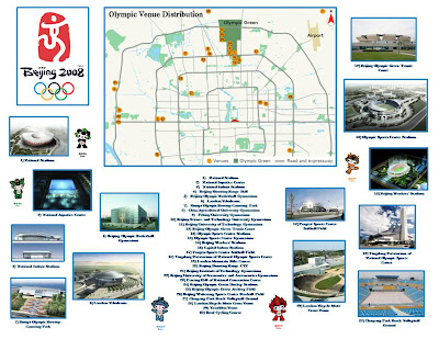
The exhibit also features the newest map of China published by the National Geographic in 2006. The GRMC created a special map of the Olympic venues with photographs of the new buildings (shown). Other maps from the GRMC featured in the exhibit are Chinese Linguistic Groups and Clothing Recommendations for Travel in China published by the Central Intelligence Agency and a map showing particulate air pollution in selected cities from 1990-1995.

These maps will be available for circulation on August 25. Maps from the GRMC circulate for two weeks or longer.

For more information, please visit the GRMC Monday through Friday from 7:30 A.M. to 4:30 P.M.

Monday, July 28, 2008

Collection of Historic Maps in Digital Media Repository


Historic Maps in Ball State University Libraries' Digital Media Repository

The newest collection in the Ball State University Libraries’ Digital Media Repository is Muncie and Delaware County Historical Maps and Atlases. This digital collection features historic maps of Muncie and Delaware County, Indiana, dating from 1826 to 1903. Towns and township maps are included in the collection. An Atlas of Delaware County published in 1887 is also included. This collection features the use of Zoomify, which allows users to “zoom in” on details.

These maps are a valuable resource for those interested in the history and growth of Delaware County during the nineteenth century.

For more information about these maps, please contact the Archives and Special Collections in Bracken Library at 765/285-5078.

Maps of Yosemite National Park in Ball State University Libraries


Maps of Yosemite National Park in the Geospatial Resources & Map Collection

Wildfires in California have now moved into an area threatening Yosemite National Park. Researchers can access dozens of maps of the park in the Geospatial Resources & Map Collection on the second floor of Bracken Library.

The Map Collection includes a new map of the park and the surrounding wilderness from 2007. This map is created with relief shown by contours and shading. Six bird’s-eye views and a map of “Yosemite creek past and present” are also included. The verso of the map tells the geologic “story” of Yosemite Valley.

Another interesting map of the national park is Satellite Orthoimage of Yosemite Valley, Yosemite National Park, California. This map of the area was created from satellite images. Map of Yosemite Region is another interesting map in the GRMC that includes a table of campground information. Maps of Yosemite Valley, Yosemite National Park, Mariposa, Bass Lake, the Sierra National Forest, and many other lakes and recreation areas are also included.

Current topographic maps of the park are also available in the GRMC, and many road maps of the state of California include inset maps of Yosemite. An official guide map of Yosemite National Park dated from 1931 is also included in the Collection, as well as a topographic map of the park from 1946.

Maps from the GRMC circulate for two weeks or longer.

Please contact the GRMC Monday through Friday from 7:30 A.M. to 4:30 P.M. at 765/285-1097.

Thursday, July 24, 2008

New Map Exhibit in Ball State University Libraries


Dogs Days of Summer: New Map Exhibit in the GRMC

University Libraries’ Geospatial Resources & Map Collection student-assistant Justine Payne created a special map exhibit for the “dog days of summer.” Payne created a map display featuring the top twenty most popular dog breeds in America according to the American Kennel Club.

The map shows a photograph of each dog in the location where the breed originated. The most popular dog, the Labrador retriever, for example, originated in Newfoundland, Canada. The Yorkshire terrier, at number two, is from England, and the German shepherd, the third most popular breed, is obviously from Germany. Germany is the most common site, with seven dog breeds originating there.

Justine Payne is a junior from Lafayette, Indiana, majoring in public history. She has worked in the GRMC for one year.

Please visit the GRMC on the second floor of Bracken Library to view this special map exhibit on display through August.

Thursday, July 10, 2008

Maps of Iran in Ball State University Libraries

Maps of Iran in the GRMC

Another location in the headlines is Iran. The Geospatial Resources & Map Collection in Bracken Library includes a set of maps of Iran, including provinces and cities of the country.

Iran Country Profile is a map of the country created in 2004 by the Central Intelligence Agency Cartography Center. This map includes a comparative area map, location map, and a list of major historical events in Iran since 1908. The map features ancillary maps of regional physiography, population density, ethno-religious distribution, key petroleum sector facilities, Southern Caspian energy prospects, and the Strait of Hormuz.

The Map Collection includes road maps, physical maps, tourist maps of the country, provinces, and cities, and maps of the people of Iran. Many of these maps are printed in English, Persian, and French. Some of the historical maps in the Collection feature bright illustrations of local costumes and handicrafts.

The GRMC also includes a set of international nautical charts including the areas surrounding Iran. Many of these nautical charts include basic maps of coastal areas.

Maps of the cities of Iran include a set of varied maps of Tehran. The New Map of Tehran includes telephone directories for accommodations for tourists and distance charts. The Guide Map of Yazd includes an index to historical monuments and sightseeing, and selected buildings are shown pictorially. The GRMC also includes maps of Isfahan city and province—both printed in Persian and English.

The Atlas Collection includes several atlases of Iran. The Historical Atlas of Iran and Atlas d’Iran are newer materials. The Atlas d’Iran is printed in French with English captions. The 1956 Atlas of Geological Maps of Southwest Persia was published by an oil company. An atlas about Iran’s White Revolution is also located in the Atlas Collection.

A current exhibit in the GRMC features a map showing the range of Iran’s missiles to the surrounding areas of the Middle East and parts of Europe and Asia.

Maps from the GRMC circulate for two weeks or longer. Atlases circulate for 28 days.

Please visit the GRMC between 7:30 A.M. and 4:30 P.M. Monday through Friday throughout the summer to view the Iran exhibit or research these resources.

Kilauea Caldera Maps in Ball State University Libraries


In the News: GRMC Maps of Hawaii’s Kilauea Volcano

The Geospatial Resources & Map Collection has a number of maps showing the Kilauea Volcano on Hawaii’s Big Island, which is currently erupting. Volcano watchers and scientists report lava bursts of up to 150 feet over the last few days, as ocean water invades the underground lava tubes.

The GRMC includes many topographic maps of the volcano at varying scales. The U.S. Geological Survey map shown is at 1:24,000-scale. The Map Collection also includes topographic maps of the Big Island of Hawaii from the Army Map Service.

A 1995 National Geographic map of the state of Hawaii includes an inset map of Kilauea Caldera (also shown). And a 1989 Geoprint map of the Big Island includes a descriptive inset map with marked features of the Kilauea Caldera.

Maps of Hawaii’s Volcanoes National Park are also available in the GRMC. The map Hawaii’s Volcanoes Revealed from the GRMC is also available digitally at http://purl.access.gpo.gov/GPO/LPS46014 . This colorful map features an image of Hawaii illuminated to emphasize sea-floor relief and includes ancillary maps showing bathymetry of the northwest Pacific Ocean, a 3-D perspective view of Hawaii, and an interpretive map of Hawaii’s volcanoes.

The GRMC also includes other maps about volcanoes around the world. Volcanoes of the World, This Dynamic Planet: World Map of Volcanoes, Earthquakes, Impact Craters, and Plate Tectonics and Earth’s Fractured Surface: Living on the Edge are some of the maps in the GRMC including information and graphics on volcanoes. The World Atlas of Natural Hazards is also available in the GRMC.

Please contact the GRMC for more information about these resources at 765/285-1097.

Tuesday, July 08, 2008

Colombia Maps and Atlases from Ball State University Libraries


Maps in the News: Colombia Maps Available in the Geospatial Resources & Map Collection

The South American country of Colombia has been in the news thanks to a daring hostage rescue by the Colombian military. The Geospatial Resources & Map Collection in Bracken Library has a number of resources about the country for those interested in learning more about Colombia.

A travel map of Colombia published in 2004 is an excellent resource. The map has inset maps of the territories of the country, San Andres, Povidencia y Santa Catalina, Malpelo, and Colombia in the world. The administrative and political divisions are also shown on the main map. Depths and contours are shown in gradient tints, and the major highways of the country are displayed. The map also includes indexes, a distance table, and illustrations.

Numerous other maps of Colombia created in varying scales are also available from the GRMC, including a unique physical map of the country. Topographic quadrant maps, a map of major industrial installations, and a map of terrain and transportation are all dated from 1944. The Map Collection also includes maps of Colombian cities, including Bogota, Medellin, Cali, Neiva, and Barranquilla.

The Atlas Collection includes a variety of atlases of Colombia. The atlases include physical maps of the country and street maps, but The Coffee Atlas of Colombia and The School Atlas of Colombia are also available.

Contact the GRMC at 765/285-1097 for more information about these resources.

Wednesday, July 02, 2008

July Map of the Month in University Libraries

July 2008 GRMC “Map of the Month” Is Disastrous

The “Map of the Month” in the Ball State University Libraries Geospatial Resources & Map Collection is a map showing great disasters that have occurred in North America—mostly in the summer. The map, Natural Hazards of North America, was produced as a supplement for National Geographic magazine in July of 1998. This map features historic hailstorms, droughts, tornadoes, and hurricanes, wildfires, and landslides.

Maps from the GRMC may be borrowed for two weeks or longer. The GRMC maintains multiple copies of National Geographic maps, so both sides of these maps can be displayed during class presentations or exhibits.

Contact the GRMC Monday through Friday from 7:30 A.M. to 4:30 P.M. for more information about this map or any other resources.

June 2008 Activities in the GRMC


What’s Happening in the GRMC? June 2008

During the month of June, a major focus of the Geospatial Resources & Map Collection was providing resources for educators:

The GIS Specialist began creating custom GIS data for Prairie Creek Reservoir in Muncie for a professor from the Department of Natural Resources/Environmental Management. The Map Collection Assistant consulted with two beginning teachers and created custom lesson plans using maps from the GRMC for use in middle school classrooms in coordination with the GRMC online maps tutorials on the Web page. Some of these lesson plans are available for use at http://ilocker.bsu.edu/users/mgentry/WORLD_SHARED

Researchers visiting the GRMC during the month of June included a marketing thesis student referencing topographic maps of Indiana, a faculty member using a World War I-era map of the Middle East for a class, and a new landowner researching the location of oil wells on his property. Students studying the history of Huntington County used maps and atlases in the GRMC, genealogists researched historic maps of Germany and Poland for their family history, and students from Geography 240 and 101 used maps from the GRMC for class assignments.

Staff of the GRMC created a map of the United States showing college towns for a graduate student in sociology. The map was printed on one of the large-format plotters available in the GRMC.

For more information about maps, atlases, GIS technology, or using the large-format plotters, please contact the GRMC at 765/285-1097.