Tuesday, April 26, 2011

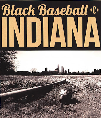
Black Baseball in Indiana Documentary Premieres April 27 in Muncie

Ball State University Black Baseball in Indiana Documentary Premiere in Downtown Muncie

The Ball State University Virginia B. Ball Center for Creative Inquiry is presenting a documentary about Negro League Baseball tomorrow, April 27, at the Cornerstone Center for the Arts in downtown Muncie. The doors open at 6:30 P.M., and the film showing begins at 7:00. The premiere is open to the public, and admission and concessions are free.

The film, Black Baseball in Indiana, was produced by fourteen Ball State students participating in a seminar exploring the league’s rich history in the state of Indiana. The students wrote a book of essays and produced this film featuring Indiana’s African American teams, players, and ballparks.

The group travelled thousands of miles interviewing leading Negro League historians, surviving players from the Indianapolis Clowns, and two of the team’s batboys. These interviews form the core of the film, supplemented with hundreds of historic photographs and vintage footage from archives around the nation.

Students from the class used road maps from the era from the GIS Research and Map Collection (GRMC) in their research of the league. The GRMC also created a map of the Negro League teams. The map is available for use from the Digital Media Repository at http://cardinalscholar.bsu.edu/1413/ or may be checked out from the GRMC.

For more information about the documentary, please contact the Virginia Ball Center at 765-285-0117.

Friday, April 22, 2011

Maps for Earth Day Available from Ball State University Libraries


Earth Day: Environmental Resources Available from Ball State University Libraries

Today is Earth Day, and the GIS Research and Map Collection (GRMC) on the second floor of Bracken Library includes many resources for researchers studying issues of the environment. The Map Collection includes flood plain maps for numerous areas, topographic maps for areas around the world, soil surveys and maps from counties around the country, Gap Analysis electronic resources for land cover, forest types, and other factors, maps of important farmlands in counties around the United States, natural gas and other energy maps, and national and state park and forest maps.

The Atlas Collection also includes a number of resources about the environment. The maps shown above are from the atlas One Planet, Many People: Atlas of Our Changing Environment, which was published by the United Nations Environment Program in 2005. Atlases in the collection cover a broad range of environmental issues, including endangered species, polluted waters, urban development, and soil degradation (shown above). Atlas of Contemporary America: Portrait of a Nation, Atlas of the Great Barrier Reef, Atlas of Wildlife, and Atlas of Global Development also include maps about the environment.

For a complete list of environmental topographic resources, researchers can access a study guide on the GRMC Web page. For more information, please contact the GRMC at 765-285-1097.


Wednesday, April 20, 2011

Map of Gulf of Mexico Oil Spill Location Available from Ball State University Libraries


Maps in the News: Gulf of Mexico—A Geography of Offshore Oil Map Available from Ball State University Libraries

Today marks the one-year anniversary of the explosion of the BP Deepwater Horizon oil rig in the Gulf of Mexico. The explosion killed 11 men working on the rig and ultimately leaked five billion barrels (206 million gallons) of oil into the Gulf, making this oil spill 19 times larger than the Exxon Valdez spill.

The National Geographic Society published a map about the Gulf of Mexico and the oil spill last year. The map, Gulf of Mexico: A Geography of Offshore Oil, shows the locations of oil platforms, wells, and pipelines on one side with information about the economy of oil in the Gulf of Mexico. The verso of the map is called The Gulf of Mexico: Layers of Life and depicts the rich habitats of “one of the most ecologically and economically productive bodies of water in the world.” Birds, animals, and marine life are shown in their coastal and marine ecosystems. The map shown above is a map of seafloor environments and marks the spread of oil along the coast up until July 25, 2010.

This map is available for research and learning from the Ball State University Libraries GIS Research and Map Collection. The map circulates for two weeks or longer.

Friday, April 15, 2011

Negro League Baseball Teams Map Available from Ball State University Libraries

Black Diamonds: Map of Negro League Baseball Teams Available from Ball State University Libraries

On this day in 1947 Jackie Robinson made his debut in Major League Baseball playing for the Brooklyn Dodgers. Robinson’s start marked the long-awaited end of segregation, which forced players to participate in a separate Negro League Baseball.

The Ball State University Libraries’ GIS Research and Map Collection (GRMC) created this map (above, click to enlarge) showing the locations and names of the Negro League Baseball teams. The map is based on the book The Complete Book of Baseball’s Negro Leagues: The Other Half of Baseball History by John Holway. Photographs on the map are from Playing America’s Game by Michael L. Cooper, which is available from the Educational Resources Collections in Bracken Library. The map was made in coordination with a special collaborative project with Geralyn Strecker, Assistant Professor in the Department of English. The base map is a 1931 road map, so researchers can imagine the routes travelled by the teams during that era of history. This map circulates for two weeks or longer and is available through interlibrary loan.

For more information, please contact the GRMC Monday through Friday at 765-285-1097.

New Location for Soil Surveys in University Libraries

Soil Surveys Available from Ball State University Libraries

Students and other researchers using soil surveys in University Libraries will now find these maps in a more centralized location. All of the soil surveys are now located on the second floor of Bracken Library, either in the Atlas Collection for circulation or next door in the GIS Research and Map Collection (GRMC) as reference materials.

All 92 Indiana counties’ soil surveys are available from the Atlas Collection on the east side of the second floor. These map books may be circulated for 28 days. Additional soil surveys of Indiana counties are available in the GRMC as reference materials. These soil surveys are maintained in the GRMC so that every county survey is always available for research. New sets of soil survey maps of Elkhart, Fountain, and Pulaski County were also recently transferred to the GRMC.

The Atlas Collection also includes soil surveys of St. Louis County, Missouri, Prince Georges County, Maryland, and Cook County, Illinois and the area near Chicago. A soil survey of Washington, D.C., is also available in the Atlas Collection. Researchers can also use soil surveys of Michigan, Ohio, Pennsylvania, Virginia, and the islands of Hawaii and the U.S. Virgin Islands in the Atlas Collection.

The GRMC also has soil maps from numerous counties around the United States. A large collection of international soil maps is also available in the GRMC. These soil maps circulate for two weeks or longer for special projects.

For more information about these cartographic resources, please contact the GRMC at 765-285-1097. The GRMC is open Monday through Friday from 8 to 5 P.M.

Wednesday, April 06, 2011

Historical Nuclear Energy Maps from Ball State University Libraries


Maps in the News: Mapping the History of Nuclear Energy

Researchers can use many cartographic resources to study the history of nuclear energy around the world. The GIS Research and Map Collection (GRMC) on the second floor of Bracken Library has a collection of maps detailing the history of nuclear power plants in the United States and around the world. The Atlas Collection also includes many atlases that feature maps depicting various energy issues, including The State of the World Atlas and the Student Atlas of Politics. The Chernobyl nuclear accident is detailed in the atlas One Planet, Many People from the Atlas Collection (top image).

The GRMC receives maps as a federal depository, and the U.S. government previously produced maps showing the location of commercial nuclear power stations around the United States. The GRMC also includes U.S. Geological Survey topographic quadrangle maps that depict the locations of nuclear power plants. The Forked River, New Jersey map shows the older Oyster Creek nuclear power plant, and the Middletown, Pennsylvania topographic map shows the four reactors at the Three Mile Island power plant (above). The GRMC also includes an aerial photograph of Three Mile Island (above).

CNN created a map so Americans can find the location of nuclear power plants around the country. Simply type in an address or ZIP code to see the plants in relation to any given location: http://money.cnn.com/news/specials/nuclear_power_plants_locations/index.html

Maps from the GRMC circulate for two weeks or longer. Atlases circulate for 28 days or longer. For more information about these resources, please contact the GRMC at 765-285-1097.