AHOY! Using Nautical Charts in the Classroom
The Geospatial Center & Map Collection includes thousands of nautical charts that may be checked out for research. (The nautical charts, however, should not be used for navigation purposes). The nautical chart collection includes charts displaying details of navigable water bodies and coastal areas of the United States and throughout the world. These charts display features such as coasts, ports, restricted waters, wrecks, currents, and cultural features such as urban areas, major roads, or buildings. Many times a nautical chart can prove to be an excellent map for coastal cities.
Mark Walker, an instructor in the Department of Biology, commonly uses nautical charts from the Map Collection in his classroom. Walker appreciates the nautical charts in his classroom: "For the last three years, I have presented a study of invasive species found in the Great Lakes ecosystem to my science education students. The maps provided to me each semester have been of the highest quality." Walker claims that the nautical charts "have great detail, are accurate, and have always been available on short notice due to the sheer volume of the collection." Apparently the nautical charts are an excellent research tool for the biology classroom. Walker explains that the students "involved with the presentation can pinpoint the important canals and rivers of the region without fail after time spent in hands-on fashion with the maps."
For more information about using nautical charts or any other maps or geographic resources from the GCMC, please contact the Center. Workshops reviewing the use of the resources of the GCMC for the university classroom will be held on September 6 at 2:00 and September 19 at 1:00 in the GCMC. Sign up for a workshop on the University Libraries Training and Technology Support page.

Wednesday, August 30, 2006
Wednesday, August 23, 2006
Travel Maps Available in the GCMC
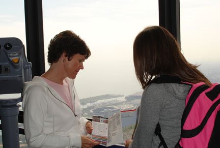
Travel to Chicago with an i.map from the Geospatial Center & Map Collection
What is an i.map? According to the publisher of the maps, the "i" stands for information, insider tips, and inherently cool. These new maps available for checkout from the GCMC are detailed city street maps. The maps provide quick, easy reference with simple-to-read symbols indicating museums, markets, department stores, hotels, theaters, scenic views, and other points of interest. A handy flip-guide features an organized listing of sights, restaurants, tours, parks, and other opportunities with valuable visitor information. These laminated folded maps are excellent for walking tours and can be easily stored in a backpack. Probably the most "inherently cool" feature of the i.maps, though, is that they include a compass--a great tool for the tourist in the city.
Currently the GCMC has i.maps for New York, Chicago, Los Angeles, Philadelphia, and Dublin, Ireland. But the entire collection of i.maps will soon be available from the GCMC. Coming soon: Boston, Toronto, Atlanta, San Diego, Seattle, Washington, D.C., Amsterdam, Barcelona, London, Paris, and many more U.S. and world cities. Simply type "imap" into the University Libraries CardCat search to check availability.
Monday, August 14, 2006
Plotter printer available in the GCMC
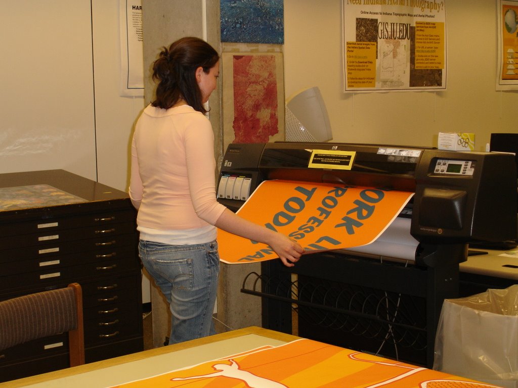
Above a representative from Ball State University Recreation Services prints a poster on the plotter in the Geospatial Center & Map Collection. Recreation Services uses these large posters to decorate the halls and display boards in Irving Gym and Ball Gym. Posters up to 36 inches wide cost $6 to print; 37 inches to 72 inches cost $8; and 73 inches and longer cost $10. The plotter may be used between 8:00 A.M. and 4:00 P.M. (an hour before closing) Monday through Friday in the GCMC.
Wednesday, August 09, 2006
Historic Atlas Added to Collection

University Libraries Add Rare Copy of 1942 Ostland Atlas to Collections
by Cecilia Bond, Cataloging and Metadata Services Librarian
University Libraries Library Insider article
The University Libraries recently added a copy of the rare Ostland Atlas to its Archives & Special Collections Research Center.
Published in 1942 by the Nazis, the atlas was created for the civil administration for the German occupied eastern territories. Ostland is the name given to the occupied Baltic states that included Estonia, Latvia, Lithuania, and Belarus in 1941. The rare atlas includes 57 folded, color maps showing the occupied administrative area, its climate and vegetation, population demographics, agricultural status, industry, energy and economic features, traffic and roads, foreign trade in 1938, and history of the area to 1943.
Paul Stout, emeritus map librarian, acquired the atlas in the 1990's from a colleague who probably overlooked, as did Stout, its value because the atlas was in another language and its container was ragged and falling apart. The atlas was put in storage until it could be evaluated for completeness and context. When reviewing materials, Map Collection Assistant Melissa Gentry found the rare atlas safely wrapped and waiting to be appraised. The atlas was promptly cataloged and added to the collection.
According to WorldCat, only two libraries in addition to Ball State University have an original copy of this publication: the University of Oxford and the University of South Carolina.
Friday, August 04, 2006
Review of the Atlas Collection
Hitting the Road...and So Much More
The Atlas Collection
Many people are familiar with road atlases—they store one in their car or they purchase one to plan for a trip. The Atlas Collection located outside the Geospatial Center & Map Collection contains hundreds of road atlases for specific counties and cities from all over the world, as well as road atlases of states and countries, and even continents.
The Atlas Collection includes road atlases for Australia, Kenya, Sri Lanka, Poland, Iran, and many other exotic locations around the world. Traveling to Iceland? There is a road atlas of the country in the Collection. Feel like hitting the road in Namibia? Yes, there is a road atlas for that country, too.
Tourists can find travel atlases, too, included in the Collection that can be used for their next vacation. Countries as diverse as Zimbabwe, Vietnam, Portugal, Turkey, Egypt, and Chile’ are included in popular travel atlases produced by Lonely Planet.
So atlases are a fantastic resource for travelers, but the Atlas Collection also includes atlases that can be used for the classroom and research covering various issues and disciplines. Atlases can prove to be an invaluable resource for both academic and personal use. The Atlas Collection contains over two thousand atlases, and nearly every country in the world is included. And many atlases focus on one singular issue, so the very specific maps included can be used in papers or presentations, and the maps can be easily scanned since they are more compact.
- History students or historians may be interested to know there are more than just general historical atlases in the Atlas Collection. The Illustrated Atlas of Native American History, Month-by-Month Atlas of World War II, Atlas of African American History and Politics, and The Atlas of the Sioux Wars are available from the Collection.
- Nursing students or others interested in health may find value in The State of Health Atlas, Atlas of Disease Distributions, or the Atlas of AIDS.
- Biology and Natural Resources students or environmentalists may find the following atlases useful: World Atlas of Desertification, Conservation Atlas of Tropical Forests, Atlas of Oceans, and Birds of North America.
- Politics is a popular topic of many atlases. Political Science students or others following politics may want to review The Atlas of Apartheid, State of China Atlas, or The Student Atlas of World Politics.
- Architects and urban planners would certainly be interested in the numerous atlases of specific cities and locations, but there are also some specific atlases that could be very useful as well. An Atlas of Rare City Maps: Comparative Urban Design, 1830-1842 and Bird's Eye Views: Historic Lithographs of North American Cities both offer historic perspectives of cities. New York: the Photo Atlas offers aerial photographs of all five boroughs of the city from 2004. And The Phaidon Atlas of Contemporary World Architecture (Travel Edition) is the first issue of this atlas available for circulation from the University Libraries.
- Educators often use atlases in the classroom to teach geography and other subjects, but there are also atlases about education available in the Atlas Collection. The Atlas of American Higher Education and Growing Up in America: An Atlas of Youth in the USA are atlases that document various issues of education in the United States.
- Anthropology, Archaeology, and Sociology students and faculty will find a plethora of topics from their classrooms covered in atlases: New Historical Atlas of Religion in America, Atlas of the Arab World, Student Atlas of Anthropology, The World Atlas of Archaeology, Atlas of World Cultures : a Geographical Guide to Ethnographic Literature, and State of Women in the World Atlas.
- Even English and literature students and faculty can find relative maps in some of the atlases in the Atlas Collection. There is an entire atlas dedicated to the works of J.R.R. Tolkien—The Atlas of Middle Earth. And The Atlas of Fantasy includes maps of fictional locations. This unique atlas includes a map of Gulliver’s travels, Hell as depicted by John Milton, the world of Sherlock Holmes from the books of Arthur Conan Doyle, and even a map of the “Hundred Acre Wood” included in the book Winnie-the-Pooh by A.A. Milne.
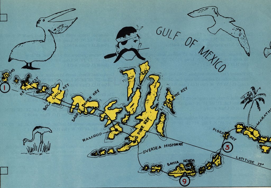
So atlases do not necessarily need to be used for serious academic purposes. The Atlas Collection also includes other atlases that are interesting and entertaining: Atlas of American Sport, USA Today Golf Atlas, Fish Michigan: 50 Rivers, and Freshwater Fishing and Hunting in Virginia cover recreational activities. The Atlas of Treasure Maps is an interesting collection of maps and nautical charts of sunken ships and shipwrecks (map shown above). And another great atlas to read for pleasure is The Traveler’s Atlas: A Global Guide to the Places You Must See in a Lifetime--the title speaks for itself.
Also, many of the atlases in the Atlas Collection have incorporated the use of GIS software and technology into the content. Several GIS-related books are included in the Atlas Collection: GIS and Crime Mapping, Exploring the Urban Community: A GIS Approach, and Think Globally, Act Regionally: GIS and Data Visualization for Social Science and Public Policy Research.
Check the University Libraries CardCat library catalog for other atlases found in other areas of the Library. Atlases like The Tobacco Atlas and The Historical Atlas of the Crusades, and many others can also be found inside the Geospatial Center & Map Collection, the Reference section, the Educational Resources Center, and the General Collection.
Wednesday, August 02, 2006
Newsworthy Maps
Maps in the News
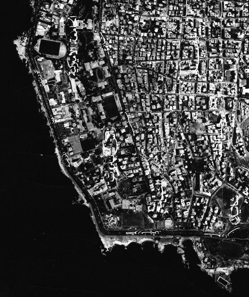
The Geospatial Center & Map Collection updates a special display of maps that are related to newsworthy world events. These "current events" maps are displayed in the windows of the GCMC. Maps produced by the CIA are commonly used in these displays because these maps are small in size and frequently updated by the government agency. Staff of the GCMC try to follow world events closely to keep this display timely and informative.
The map shown above is an aerial photograph of Beirut, Lebanon, that has been on display during the month of July. The actual map is much larger and covers the entire city of Beirut. This map and the CIA maps used in displays are available for checkout from the GCMC.
July 2006 Map Displays
In the Window...
July 2006 GCMC "Map of the Month"
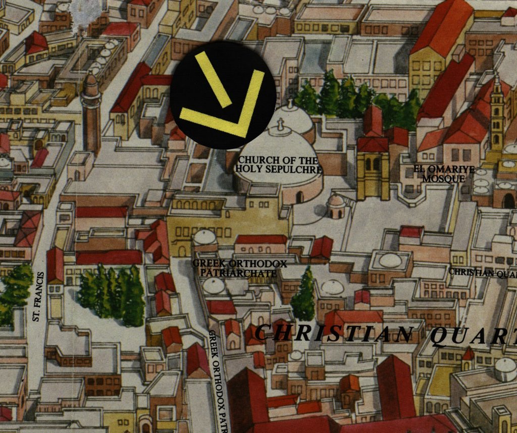
The July 2006 "Map of the Month" was actually two maps of the old city of Jerusalem. These maps were chosen to mark the July anniversary of the Church of the Holy Sepulchre. The first map was produced by National Geographic in February 1996 called The Old City of Jerusalem: A Divine Mosaic. The second map, The Old City of Jerusalem, was produced in 2001 by PointOut. This map, shown above, is actually a bird's-eye view map of the city.
Both maps are available for checkout from the Geospatial Center & Map Collection. Maps from the Center circulate for two weeks.
July 2006 GCMC Events

What's Happening in the GCMC? (July 2006 Edition)
The month of July brought many different people and projects to the GCMC:
Archeology professor Mark Groover needed a special map for a book he is writing, The Historical Archeology of Farmsteads. Angela Gibson, GIS Specialist, created a GIS map of the eastern United States showing specific archeological sites to be included in the book, which will be published by the University Press of Florida.
Carol Shears, Professor of Geography, developed an extra-credit assignment using maps from the Collection for her summer Geography 101 classes. Students used topographic maps, street maps, and bird's-eye view maps of a U.S. city of their choice to study the city's urban development and growth over time. Students selected from Las Vegas, Nevada; Los Angeles, California; Miami, Florida; Baltimore, Maryland; San Diego, California; Indianapolis, Indiana; or Denver, Colorado. Perhaps not surprisingly, Las Vegas was the popular choice.
July also seemed to bring international activity to the GCMC: The director of the Ball State University London Center for the 2007 spring semester and the current director of the Australia Center both utilized the GCMC in preparation for the upcoming study-abroad programs. Specific topographic maps and aerial photography of the area around the Australia Center in Lennox Head were even purchased for use in classes in Australia.
Professors and students from various departments and classes used GIS software, maps, atlases, and nautical charts for their various summer projects. The GCMC welcomed students and faculty from the College of Architecture & Planning, Spanish, Biology, and Geography.
Local historians also visited the GCMC in July. One project involved searching for an Indiana city that was completely destroyed by a tornado and never rebuilt. Historic topographic maps from the Collection revealed the location of this missing town. Another project involved reviewing historic atlases of Virginia for genealogy research. The historian used the atlas, Virginia in Maps: Four Centuries of Settlement, Growth, and Development, located in the Atlas Collection.
Please visit the GCMC for GIS assistance or to use the maps, atlases, and other resources available in the Center. The GCMC will be open from 7:30 A.M. to 4:30 P.M. during the week through August 11. Regular 8:00 A.M. to 5:00 P.M. academic year hours resume on August 14.
Subscribe to:
Posts (Atom)