Tuesday, November 25, 2008

Rare Maps of Ottoman Empire at Ball State University Libraries


Focus: Turkey
Rare Maps of the Ottoman Empire in Ball State University Libraries


In honor of the Thanksgiving holiday, the Geospatial Resources & Map Collection (GRMC) is featuring an exhibit of rare maps of the Ottoman Empire, which is centered in present-day Turkey.

The GRMC has two rare maps of the Ottoman Empire from 1877. The first is titled The Cross and Crescent—Harper’s Pictorial Map of the Seat of War in the East and was a supplement to Harper’s Weekly magazine in June 1877. Map of the Ottoman Empire, Kingdom of Greece and the Russian Provinces on the Black Sea was an extra supplement in the Illustrated London News on April 21, 1877. Ball State University Libraries is listed in WorldCat as the only library in the world possessing these two unique maps.

Carte Generale L’Empire Ottoman is another map of the Ottoman Empire in the GRMC. This map was created by Dietrich Reimer in 1867 and is mounted on canvas. The glossary on the map is written in Greek, Turkish, Arabic, and Persian. Ball State University Libraries is one of three in the world with this map according to WorldCat.

The GRMC also includes a reproduction of a map of Imperial Turkey from 1737, a map of the conquests of Murad I and Bayezid I, and reproductions of maps of Constantinople from 1493, 1572, and 1635.

Current road and tourist maps of Turkey are also available from the GRMC. Several maps of Turkish cities are in the Collection, including Ankara, Istanbul, and Izmir.

All maps from the GRMC can be circulated for two weeks or longer. For more information about these maps of Turkey or any other maps in the GRMC, please contact Melissa Gentry at 765/285-1097.

Monday, November 24, 2008

Thanksgiving Holiday Hours in the GRMC


Thanksgiving Hours for the Geospatial Resources & Map Collection

The Geospatial Resources & Map Collection will be closed on Thursday, November 27 and Friday, November 28 for the Thanksgiving holiday. The Geospatial Resources & Map Collection will resume regular business hours (Monday through Friday 8:00 A.M. to 5:00 P.M.) on Monday, December 1.

Monday, November 17, 2008

National Geography Awareness Week and GIS Day in University Libraries


GRMC Celebrates National Geography Awareness Week and GIS Day

The Geospatial Resources & Map Collection (GRMC) on the second floor of Bracken Library is celebrating National Geography Awareness Week November 17-21, 2008, including GIS Day on November 19.

The theme for the 2008 National Geography Awareness Week is “The Americas.” The GRMC is featuring an exhibit of National Geographic’s Americas map. Each day ten questions will be listed next to the map in the front window of the GRMC. Test your geographic knowledge with this daily geography challenge. The goal is to answer the questions without looking at the accompanying map.

The GRMC is also hosting a GIS Day Open House from 9:00 A.M. to 3:00 P.M. on Wednesday, November 19. Visitors can discover how to access online and in-house GIS data, learn how GIS is being used by various departments at Ball State University, learn about in-house and online GIS tutorials, and request access to GIS software, workshops, and one-on-one training.

Please contact the GRMC at 765/285-1097 for more information about National Geography Awareness Week and GIS Day.

Ball State University Students Create Indiana Food Trail Maps


Indiana Foods Trail Maps Created by Ball State University Students

The Indiana Building Better Communities initiative was created to spur economic development in the state. The Business Fellows program at Ball State University is part of that initiative, and last year students from the program worked to create a project and Web site promoting Indiana’s traditional foods.

“Students in the program partnered with Indiana Foodways…to establish the non-profit start-up,” according to Claire Arbogast in an article, "A Recipe for Mouth-Watering Tourism," in the Ball State Alumnus magazine’s November 2008 issue. “Students devoted hours to building the Indiana Foodways’ brand identity and Web site http://www.indianafoodways.com/, producing food-story broadcasts and articles…building a database of Indiana-made foods and a photography resource library…and designing promotions.”

The students created eight culinary trails that cross the state featuring Indiana staple foods like the sugar cream pie, tenderloins, candy companies, tea rooms, and bakeries, including Concannon’s Pastry Shop in Muncie. The “interactive maps help you plan wonderful day and overnight trips so that you can discover where some of the most incredible food can be found right here in Indiana.” Tourists can download PDF files of the trail information.

University Libraries’ GIS Specialist Creates Research Maps of Indiana Education


Research in the GRMC: Mapping Test Scores for the Indiana Education Project
By Angela S. Gibson

Angela Gibson, GIS Specialist in the University Libraries Geospatial Resources & Map Collection (GRMC), recently collaborated with Ginny Burney, a consultant of High Ability Education with the Indiana Education Project in the Teachers College, to create GIS data and maps.

Tabular data collected by Dr. Burney from the Indiana Department of Education Web site was linked to existing GIS shapefiles of Indiana school district boundaries that were downloaded from the IndianaMap Web site, http://www.indianamap.org/. The combination of this data was used to create new GIS layers that were entered into a digital map showing Advanced Placement test performances according to school corporation boundaries in the state using the ESRI ArcGIS 9.3 software. Two additional maps were also created showing the school district demographic types and the number of graduates for the school corporations.

The data shown on the maps will be used by Dr. Burney to demonstrate findings in research that reveal few small and/or rural schools are preparing many, if any, of their students at the level that is predictive of college graduation, according to the Advanced Placement measure. These GIS-generated maps will be shared at presentations around the state, in Dr. Burney’s graduate classes for Indiana teachers, and with key legislators in an effort to investigate solutions for this problem.

For more information, please contact Angela Gibson in the GRMC at 765/285-1097.

Wednesday, November 12, 2008

GIS IndianaMap Road Show at Minnetrista Cultural Center


GIS Map “Road Show” in Muncie

The Indiana Geographic Information Council (IGIC) is presenting a series of “Road Shows” designed to inform Hoosiers—especially those in local government—how the IndianaMap legislation is changing GIS across the state. The legislation was enacted last year and mandates the creation of a single, statewide, digital map for Indiana.

The next “Road Show” will be held on Tuesday, November 18 at Minnetrista Cultural Center in Muncie, Indiana, from 10:00 A.M. to 3:00 P.M. Specific topics will include data sharing between different levels of government, funding opportunities, and future IndianaMap initiatives. Morning sessions will provide information about the map project: its benefits, impact, and long-term goals. Speakers will demonstrate how local data is already being incorporated into the IndianaMap and outline grants available to local governments to support their participation. Afternoon sessions will focus on Web Feature Services (WFS). This new technology will be the mechanism for combining data into a seamless statewide map. Speakers will be Jim Sparks, Indiana Geographic Information Officer, Phil Worrall, IGIC Executive Director, and representatives from the Indiana Department of Homeland Security. A technical presentation on WFS will be given by Jeff Ehman of Image Matters.

For more information about the “Road Show” events, please contact the Indiana Geographic Information Council at 317/234-2924.

Native American Heritage Month Events at Ball State University Libraries


Native American Heritage Month Events at Ball State University Libraries

Dr. Kenan L. Metzger, assistant professor in the Ball State University Department of English, will speak at Bracken Library in the Forum Room tonight, November 12, at 7:30 P.M. Dr. Metzger will present, Native Ways of Knowing Along with Traditional Western Thought, a program sponsored by the Friends of the Alexander M. Bracken Library.

Dr. Metzger’s research reveals that educational institutions continue to either negatively portray or ignore the Native American experience, which adversely affects the lives of students and faculty. In his talk, Dr. Metzger will discuss ways that educators can provide more collaborative experiences in the classroom and incorporate individual cultural experiences.

This presentation coincides with a new exhibit on the second floor of Bracken Library for Native American Heritage Month. The Archives and Special Collections, the Geospatial Resources and Map collection, and Educational Resources Collections collaborated to display various items for the exhibit located in the display cases outside the Archives. Photographs from the Miami Indian photo collection, historical texts, and books from the Archives and Special Collection are featured in the exhibit. The Geospatial Resources and Map Collection provided maps showing the location of Delaware settlements along the White River, the Navajo Nation, Indian Tribes and Trapper Trails, a map highlighting the influence of the Indian on Indiana natural and cultural location names, and many others. Educational Resources Collections exhibited several unique Indian artifacts, including a rawhide rattle, a peace pipe, a breast plate, and a shield. The Anthropology Department also provided pottery and arrowheads for the exhibit.

The exhibit, Native America at the Crossroads: Resources Celebrating Native American Heritage Month, will be on display from November 12 through December 31, 2008.

The GRMC is also featuring a Native American map for the “Map of the Month” exhibit for November. The map, Native American Heritage: A Visitor’s Guide, was produced by the National Geographic Society in 1991 and includes inset maps of “Great Plains, “The First Americans,” “Eastern Woodlands,” “Desert West,” and the “Far West.”

For more information about the special exhibit or the presentation, please contact John Straw, Assistant Dean for Digital Initiatives and Special Collections and Executive Secretary for the Friends of the Alexander M. Bracken Library, at 765/285-5078.

Friday, November 07, 2008

Ball State University Maps Featured in Veterans Day Exhibit

Maps from Ball State University Libraries Featured in Local Veterans Day Exhibit

Several maps from the Geospatial Resources & Map Collection will be featured in a local elementary school’s Veterans Day exhibit. Charity Loveless, a student-teacher from Ball State University, consulted with the GRMC to create the special display for Shenandoah Elementary School in Middletown, Indiana.

Over twenty war-related maps will be featured in the exhibit. The maps date back to World War II, the Korean War, the Vietnam War, the Persian Gulf War, the civil war in Yugoslavia, and the current wars in Iraq and Afghanistan. Maps and other images from atlases from the University Libraries Collection were also displayed. One poster (shown) created from the atlas images showed several U.S. presidents and generals using maps during a press conferences, meetings, and battles during wartime.

Miss Loveless was excited about introducing the young students to original maps from the war era. The maps will be a colorful, historical addition to the special Veterans Day celebration at the school, which is attended by students, staff, family and community members, and veterans.

For more information about using maps from the GRMC for a special school or other community exhibit, please contact the staff at 765/285-1097.

International Festival Held at Ball State University Libraries

Ball State University Libraries Welcome the World

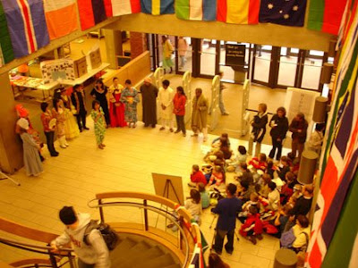
The annual Rinker Center for International Programs’ International Festival was held in the lobby of Bracken Library on Friday, November 7. The festival featured booths representing over thirty countries from around the world.

Students shared information about their home countries, displaying artifacts, artwork, maps, photographs, and even videos. Visitors were invited to taste the various foods and drinks offered at the different booths. Music from around the world played throughout the festival, and a fashion show exhibited the beautiful clothing worn across the globe.

The Geospatial Resources & Map Collection provided maps used during the festival. This year maps from every country were displayed in the booths, including Taiwan, Pakistan, China, Korea, Russia, Uruguay, Jamaica, Botswana, Burkina Faso, and many more nations around the globe. Educational Resources Collections provided a poster of the flags of the world so that visitors to the Festival could identify the flags decorating the stairwell in the lobby.

A fashion show, music, dance, and other performances will be held at 6:30 P.M. Friday in the Fine Arts Building.

Thursday, October 23, 2008

Report from the Ball State University Storm Chase Team


Report from the Ball State University Storm Chase Team

Each summer the Ball State University Storm Chase Team travels through the middle of America researching thunderstorms, tornadoes, and other extreme weather conditions. The mission of the team is “to provide the east-central Indiana community…timely information regarding the state of severe thunderstorms within the local area.” The team hopes their research will provide more understanding about the atmospheric environment of the area.

This year the team was led by Dr. David Call, Assistant Professor in the Department of Geography. The team traveled the Plains from May 19 through June 3, passing through nine states and covering 6,000 miles. The team went from Indiana through Illinois and Iowa to Nebraska, then chased storms into Colorado, spent time in Kansas, and wandered into Oklahoma and Texas. Then the team ventured back to Kansas and Missouri. Most of the time was spent in Kansas. “The class was a success. We saw a tornado, and nothing bad occurred,” according to Dr. Call. Photographs of the trip can be viewed at http://dacall.shutterfly.com/?emid=collectview&linkid=link4

Dr. Call is looking forward to the 2009 trip, and student interest is growing. For more information about the Ball State University Storm Chase Team, phone 765/285-1766 or visit http://www.bsu.edu/web/stormchasers/

Wednesday, October 22, 2008

Google Maps Technology Used for Online Map Collection

University Libraries Use Google’s My Maps to Create Interactive Maps for the Sanborn Map Collection of Muncie in the Digital Media Repository

Students, faculty, and researchers searching for Sanborn® Fire Insurance Maps of Muncie in the University Libraries’ Digital Media Repository now have a new tool for using the collection: a Google map. Angela Gibson, GIS Specialist in the Geospatial Resources and Map Collection, created Google maps showing the locations of the 200 individual map sheets for Sanborn® Fire Insurance Maps of Muncie, Indiana.

The insurance maps depict Muncie’s commercial, industrial, and residential sections in 1883, 1887, 1892, 1896, 1902, and 1911, and were produced by the Sanborn Map Company to assist fire insurance agents in determining the degree of hazard for establishing premiums for particular properties. This new resource will greatly aid researchers in locating and analyzing the changes of a specific area of Muncie over the years. The Google map is also beneficial because students and faculty can see how the study area currently appears. Users can view the Google map with satellite images turned on or with only roads activated.

Google My Maps was used to create this interactive map because of its ease of use, and many people are already familiar with the Google Maps format. My Maps also integrates well with ESRI ArcGIS software. For the Sanborn collection, the maps were created in ArcMap and then exported as KML files. Once in this format, they were imported into Google My Maps, where the maps could be customized and linked to records in the Digital Media Repository.

To access the Sanborn Map Collection Interactive Map, click on View Google Maps of this Collection, from the Sanborn® Fire Insurance Maps Collection main page in the DMR, http://libx.bsu.edu/collection.php?CISOROOT=/SanbrnMps, or access this resource directly at
http://libx.bsu.edu/cdm4/sanborn_google.php.

Tuesday, October 21, 2008

Election Cartographic Resources in Ball State University Libraries

Election Selections: Resources Available in the Geospatial Resources and Map Collection

Election Day is only weeks away, and maps can be an ideal tool for illustrating information and statistics about elections. The widely-used "blue states and red states" explanation of states' party affiliations has become a cultural phrase made popular by an election map from the 2000 Presidential election.

University Libraries’ Geospatial Resources and Map Collection (GRMC) houses many maps, atlases, and other resources about elections--both current and historical. Maps depicting newly-drawn Congressional districts, maps showing election results, and maps of local election precincts are available for research in the GRMC. U.S. Census data is also available in the GIS lab, and users can access more election statistics from CD-ROMs in the Collection.

One of the most popular election maps in the GRMC is National Atlas of the United States of America: Presidential Elections, 1789-2000. This map (shown above), published by the federal government, shows how each state voted in every presidential election since 1789 with red states depicted as Democratic and blue states as Republican. It features a larger map of the election results of the controversial 2000 election. The main map displays the popular vote by county; an inset map shows the results of the electoral vote. Indiana presents an interesting study in cultural history on the map: Indiana has voted for the Republican candidate in all but four presidential elections since 1896.

The Atlas Collection also provides excellent election resources. Atlas of American Politics 1960-2000 features several maps about elections, including voter turnout. This atlas also contains maps illustrating important events such as the impeachment vote of President Clinton and topics such as the environment, capital punishment, abortion, and the number of women serving in state legislatures. The Atlas Collection also includes election resources from other countries, including the first elections in Kosovo and Poland.

Researchers can also access a new cartographic study guide from the GRMC, Cartographic Resources for Political Science and Election Research, at http://www.bsu.edu/library/media/pdf/poliscienceresourcesguide.pdf. Voters may even find these election resources helpful in making their Election Day selections.

The GRMC is open Monday through Friday from 8:00 A.M. to 5:00 P.M.

Environmental Study Guide Available in University Libraries


Cartographic Resources Guide for Environmental Studies Available from Ball State University Libraries

The Geospatial Resources & Map Collection on the second floor of Bracken Library includes many resources for researchers studying issues of the environment. The Map Collection includes flood plain maps for numerous areas, topographic maps for areas around the world, soil surveys and maps from counties around the country, Gap Analysis electronic resources for land cover, forest types, and other factors, maps of important farmlands in counties around the United States, natural gas and other energy maps, and national and state park and forest maps. Maps of the rainforest, endangered species, desertification, and wetlands are available in the GRMC.

The Atlas Collection also includes many resources for environmental studies. Several atlases about water resources, endangered species, and threatened environments are available in the Collection. One Planet, Many People: Atlas of Our Changing Environment features maps and images on global environmental change, human beings effect on nature, nature conservation, and international cooperation in environmental protection. Other atlases focus on one specific environmental issue or threatened area—Atlas of the Great Barrier Reef, The Last Rain Forests: A World Conservation Atlas, Solar Radiation Energy Resource Atlas of the United States, Conservation Atlas of Tropical Forests: Asia and the Pacific.

Now researchers can access a complete list of all the cartographic resources for environmental studies on the GRMC Web page. A new study guide is available at http://www.bsu.edu/library/article/0,,59405--,00.html. Call numbers and locations of the maps and atlases are listed so that users can easily find relevant materials for their studies.

For more information about this study guide or any of the resources listed, please contact the staff of the GRMC at 765/285-1097.

Monday, October 06, 2008

Culture Exchange Programs in Bracken Library


International Center Culture Exchange Programs Held Weekly in Bracken Library

The Ball State University Rinker Center for International Programs is once again sponsoring the Culture Exchange program. Each week a speaker will present a program about a particular country. The Culture Exchanges begin at noon and are being held this year in Bracken Library room 225, the Forum Room. Attendees are welcome to bring a sack lunch or snack.
The schedule for upcoming presentations includes:

Nepal—October 8
Digital Down Under: Australia—October 15
Mexico—October 22
Botswana—October 29
Thailand—November 5
China—November 12
Russia—November 19
Turkmenistan—December 3

The Rinker Center is also sponsoring the annual International Festival (shown above) on November 7. The Ifest will be held again this year in the lobby of Bracken Library.

For more information about these programs, please contact Debra Goens, Director of International Student Services, at 765/285-5422.

Wednesday, October 01, 2008

Ball State University Libraries Map Shows Russian/American Border

Alaska Map from the GRMC Reveals Close Proximity of Russia and the United States

More Americans are becoming aware of the border between Russia and the United States thanks in part to John McCain’s selection of Sarah Palin, Governor of Alaska, as his running mate in the presidential election. The Bering Strait separates the two countries, and the islands in the Strait are considered strategically important.

The Diomedes Islands lie on either side of the International Date Line in the Bering Strait. When Alaska was purchased from Russia, Big Diomede Island remained Russian, but Little Diomede became territory of the United States. During the winter season, the channel between the two islands freezes over, making it possible to walk the approximately 2.5 miles between them. America’s Little Diomede is about thirty miles from Siberia. St. Lawrence Island lies about forty miles from Siberia.

The islands and their proximity to Russia to the northwest are shown on the map above. (Click on the map for a larger view). This map of Alaska was produced by the National Geographic Society in 1994 and is available for circulation from the Geospatial Resources & Map Collection on the second floor of Bracken Library. The call number for the map is G4370 1994.N31.

Tuesday, September 30, 2008

Wall Street Maps Available in Ball State University Libraries


Aerial Views of Wall Street in the Geospatial Resources & Map Collection

Recent events have put the focus of the nation on Wall Street and the financial district in New York. These aerial views of Wall Street are from the Geospatial Resources & Map Collection and Atlas Collection in Ball State University Libraries. The first map, Downtown Manhattan: An Axonometric View of the Big Apple, shows a view of the financial district from 1994. The base of the former World Trade Center is shown in the top left corner of the map. The second view is from the New York Photo Atlas from 2004 in the Atlas Collection. The World Trade Center site can be clearly viewed in the top left corner. (Click on the images for a larger view).

Maps from the GRMC circulate for two weeks or longer. Atlases circulate for 28 days. For more information about these maps and atlases, please contact the staff of the GRMC at 765/285-1097.

Thursday, September 25, 2008

New Subject Guides at Ball State University Libraries


New Cartographic Guides Available from the Geospatial Resources & Map Collection

Students and other researchers of religious studies can now use a subject guide on the GRMC Web page to access the cartographic resources available in University Libraries. The subject guide, Cartographic Resources for Religious Studies, is available at http://www.bsu.edu/library/article/0,,59405--,00.html.

Another subject guide, Anthropology and Archaeology Cartographic Resources in University Libraries, was also added to the Web page to assist researchers in those fields of study.

The subject guides provide a list of all of the maps, atlases, gazetteers, and other resources available from University Libraries. The subject guides from the GRMC enhance the library guides available from Instructional Services at
http://www.bsu.edu/library/electronicresources/researchguides/.

For more information about these cartographic guides, please contact the Geospatial Resources & Map Collection office at 765/285-1097.

Friday, September 12, 2008

Hispanic Heritage Month Map Exhibit in Ball State University Libraries

Hispanic Heritage Month Map Exhibit in Ball State University Libraries

September 15th marks the beginning of Hispanic Heritage Month in the United States. Seven Latin American countries declared their independence during the month of September, and Columbus Day also falls within this period of celebration. A special map exhibit commemorating Hispanic Heritage Month is currently on display in the Geospatial Resources & Map Collection on the second floor of Bracken Library. The exhibit features maps and images from the Atlas of Hispanic-American History available in the Atlas Collection.

For more information, please contact the staff of the GRMC at 765/285-1097.

Wednesday, September 10, 2008

September 11 Map Exhibit at Ball State University Libraries

Special Map Exhibit for September 11 Memorial

An exhibit in Ball State University Libraries marks the seventh anniversary of the September 11, 2001, terrorist attacks. The “Maps in the News” section of the Geospatial Resources & Map Collection on the second floor features maps from the New York Times and Time magazine from September of 2001 showing the flight paths of the planes involved in the attacks and a map of the World Trade Center site in New York. A recent aerial image of Ground Zero (shown above) from the New York Photo Atlas available in the Atlas Collection is also featured in the exhibit.

Election Cartographic Resources Available in Ball State University Libraries

Online Guide to Political Cartographic Resources in University Libraries

The presidential election is less than two months from today. Maps are an ideal tool for illustrating various information and statistics about elections. The widely-used "blue states and red states" explanation of states' party affiliations has become a cultural phrase and was made popular from an election map used during the 2000 Presidential election. Voters may find maps and other cartographic resources informative and helpful in making their election selections.

Now voters and other politicos can access an online subject guide for cartographic resources for political science and election research on the Geospatial Resources & Map Collection Web page. Cartographic Resources for Political Science and Elections Research in Ball State University Libraries lists the many maps, atlases, and other cartographic resources available throughout many departments of the Library. The guide is available on the “Subject Guides “ page at http://www.bsu.edu/library/article/0,,59405--,00.html.

The Geospatial Resources & Map Collection houses many maps and atlases about elections--both current and historical. Maps depicting newly-drawn Congressional districts, presidential election results since 1789, and even local city council districts are available in the GRMC. U.S. Census data is also available in the GIS lab of the GRMC.

The Atlas Collection also provides excellent election resources. The Routledge Historical Atlas of Presidential Elections, Student Atlas of World Politics, Atlas of African-American History and Politics, and The Historical Atlas of Political Parties in the United States Congress are very current and thorough sources of information. Atlas of American Politics 1960-2000 features several maps about elections: Voter Turnout; Democratic Campaign Stops, 2000; Republican Campaign Stops, 2000; Party Affiliation in the House of Representatives. But the atlas also contains more specific political maps: Senate Vote to Convict or Acquit President Clinton on Impeachment; Cabinet Secretaries' Home States; Supreme Court Justice Confirmation Votes; Women in State Legislatures. And this atlas also features maps describing issues important to voters: Per Capita Hazardous Waste Generation; Methods of Capital Punishment in Each State; Violent Crime Rate; Teacher Salaries; Abortion Rates; Firearm Injury Death Rate. There are even rare atlases covering the first elections in Kosovo and elections in Poland.

The General Collection includes many books and other atlases related to elections and voter issues, including Wealth Beyond Measure: An Atlas of New Economics and Gaia Atlas of Green Economics. Government Publications on the first floor of Bracken Library includes many statistical books, reports, and atlases about the elections, including Atlas of Foreign Relations and Census Atlas of the United States. Atlases in the Reference Collection also provide election information, including Atlas of Contemporary America: Portrait of a Nation—Politics, Economy, Environment, Ethnic and Religious Diversity, Health Issues, Demographic Patterns, Quality of Life, Crime, Personal Freedoms.

Subject guides for all resources in the Library—including political science and elections—are available at http://www.bsu.edu/library/electronicresources/researchguides/.

Contact the staff of the GRMC for more information about the subject guides or any of these election resources.

Thursday, September 04, 2008

Ball State University Campus Maps Available on Digital Media Repository


Ball State University Campus Maps Available Online

A new collection of maps has been added to the Ball State University Libraries Digital Media Repository at http://libx.bsu.edu/: Ball State University Campus Maps. The Ball State Campus Maps collection contains maps of the Muncie, Indiana, campus dating from 1929-2000. These maps provide an excellent resource for exploring the expansion of the campus over the last century.

The Collection includes maps from the Geospatial Resources & Map Collection (GRMC) and the Archives and Special Collections. Maps from the GRMC are available for regular circulation. Users can determine a map’s availability by using the link to University Libraries online card catalog, CardCat, by using the link in the document description view, “locate this file in CardCat.” More maps of the Ball State University campus are available in the GRMC.

Tuesday, September 02, 2008

New GIS Tutorial Available on GRMC Web Page

New GIS Tutorial Available on GRMC Web Page

Interested in adding Google maps to a Web page? A new online tutorial on the Geospatial Resources & Map Collection Web page provides step-by-step information about the process. The online tutorial, Adding Google Maps to Your Web Page, is now available under the “Online GRMC GIS Tutorials” section of the GRMC Web page at http://www.bsu.edu/library/collections/gcmc/.

Other GIS tutorials available on the page include Census Data: Downloading and Using in ArcMap, Creating and Editing Shapefiles in ArcMap, Creating KML Files for Google Earth, Downloading Data and Creating a Layout, GIS for Journalism and Media, GIS Introduction, and Using BusinessMAP 4.5.

For more information about these tutorials, please contact the GRMC between Monday through Friday at 765/285-1097.

Track Atlantic Hurricanes Using Online Mapping


Track Hurricanes Using Online Mapping

Google has coordinated several mapping resources on its Web page to “enable all Americans to keep up-to-date” on the progress of hurricanes. A very useful map resource on the page is listed as “Atlantic Ocean—Hurricane Path Tracking and Storm Status Information.” Clicking on the link accesses this site: http://stormadvisory.org/map/atlantic.

Users can click on the plus sign by the name of the storm or multiple storms to see the possible path near the United States. All the storms of 2008 can also be tracked, showing the status as a tropical depression, tropical storm, and the level of hurricane each storm reaches.


Wednesday, August 27, 2008

Cartographic Subject Guides Now Available from Ball State University Libraries

Cartographic Subject Guides Now Available on University Libraries Web Page

University Libraries preserves a wealth of valuable cartographic resources on various topics. Now researchers can access cartographic subject guides on the Geospatial Resources & Map Collection Web page. At http://www.bsu.edu/library/collections/gcmc under “Maps and Atlases,” review a complete listing of maps, atlases, and other cartographic resources listed by subject.

These guides provide information about resources in the GRMC and Atlas Collection, but also the Archives and Special Collections, Educational Resources Collections, Government Publications, the Architecture Library, and the reference and general collections. Some of the guides include African-American, Native American, women’s studies, and English/Literature cartographic resources. The guides will be frequently updated, so check the list regularly.

For more information about the guides or to research cartographic resources about a specific subject, contact the GRMC staff.

Geospatial Resources & Map Collection in the Classroom or as the Classroom

Back to School with the GRMC

Faculty and community groups are encouraged to use the resources of the University Libraries Geospatial Resources & Map Collection in the classroom or as a classroom for research and learning. The GRMC will create an instruction session tailored to the needs of students on such topics as finding and using maps, types of maps and their use, sources for locating geospatial data, and tools for researching geographical information.

Class assignments requiring the use of the GRMC or any part of its resources are encouraged. Materials from the Collection may be used in a special study area of the GRMC, and faculty may reserve maps when an entire class will be using the materials. The special use of certain materials in the classroom for up to a semester at a time may also be coordinated.

The GRMC Web page can be accessed at http://www.bsu.edu/library/collections/gcmc/. On the GRMC Web page under the “Maps and Atlases” section, click on “Online GRMC Map Tutorials” to find a list of maps tutorials to use in the classroom. Kindergarten through secondary teachers of various subjects can access online lesson plans using cartographic resources using the tutorial, Teaching with Maps: Lesson Plan Guide from the GRMC. Social studies teachers can also review the tutorial, Using Maps and Atlases in Social Studies Lessons.

The GRMC Web page also features online GIS tutorials under the GIS section. These tutorials provide an introduction to using GIS software, using U.S. Census data, and using Google Maps and Google Earth.

Orientation tours of the GRMC for school and community groups may also be arranged. Small-group presentations can also be accommodated in the GRMC or at another venue.

To request an instruction or orientation session, please complete the “Request for GRMC Instructional Session” form under the “Instruction/Workshops” sections of the GRMC Web page or contact the GRMC directly at 765/285-1097.

Monday, August 25, 2008

Democratic and Republican National Conventions Sites Maps in University Libraries


2008 National Conventions Maps Exhibit in University Libraries

The Geospatial Resources & Map Collection on the second floor of Bracken Library is featuring a special map exhibit for the Democratic and Republican National Conventions. The exhibit displays maps of Denver, Colorado, and St. Paul, Minnesota.

The map of Denver shows an outline view of the Pepsi Center, where delegates will meet, and INVESCO Field at Mile High, where Senator Barack Obama will accept the Democratic nomination for President of the United States. The map of downtown St. Paul shows the location of the Republican National Convention at Xcel Energy Center.

Both maps are available for circulation from the “ready reference” section of the GRMC. Maps circulate for two weeks or longer.

Monday, August 18, 2008

Historic Map of Hungary in the Ball State University Libraries


Historic Map of World War I-Era Hungary Available in the Geospatial Resources and Map Collection

The Ball State University Libraries Geospatial Resources and Map Collection was enriched over the years with 25,000 maps and 2,000 atlases acquired through a special Library of Congress program due to the participation of the now retired map librarian, Paul W. Stout. Stout participated in six of the Library of Congress Geography and Map Division Special Summer projects—each lasting six weeks—between 1977 and 1996. These maps are valuable—sometimes historically significant—resources that can be used to enhance research and learning for Ball State University students and faculty.

The Library of Congress Geography and Map Division Special Summer Project was developed in 1951 to employ the use of interns to process the backlog of maps that the Division received from federal libraries and government mapping agencies after World War II. Ball State University Libraries was one of the many institutions to sponsor a participant in the program over the years. In exchange for their work, participants were able to select duplicate maps and atlases from the Library’s stock and send them back to their sponsoring libraries.

During a four-hour selection period in the 1983 Special Summer Project, Stout discovered two maps he suspected were not duplicates. The maps were of the Hungarian portion of the Austrian-Hungarian Empire dated 1919. One of the maps had specific notations indicating it had been used at the Peace Conference in Versailles, France following World War I. Stout remembers reading “American Commission to Negotiate Peace” stamped on the map. (The Treaty of Trianon was organized as part of the Peace Conference at Versailles in order to determine the borders of Hungary and was signed in June of 1920, so the American delegation may have used these maps as a resource for the peace negotiations).

Stout quickly showed the two maps to the Chief of the Geography and Map Division. The chief thanked Stout and immediately took away the maps. However, to Stout’s surprise, the un-annotated map was returned to him an hour later. Stout did not take the time to record information about the other annotated map because he was preoccupied with selecting as many maps as possible for the BSU Collection. Stout also noted that he did not ask the Division Chief for details “because I thought he might decide he wanted back the second Hungarian map.”

Stout recalled both maps having identical ownership stamps—first belonging to the U.S. State Department in 1919 then transferred to the Central Intelligence Agency in 1949. The map measures over six feet by almost ten feet in size. The title of the Ball State map is Ethnographical Map of Hungary—Colonization and Population by S. Batky and Ch. Kogutowicz dated 1919. The map states “designed by order of the Foreign Ministry of the Hungarian Republic.” The map shows the areas where ethnic Hungarians were predominant. This information was one of the criteria for the negotiations used by the Americans at the treaty. Based on circumstantial evidence, Stout believes this map was used by the American Delegation to Negotiate Peace in preparation for the determination of Hungarian territory.

Paul related the story of the map to Melissa Gentry of the GRMC and Steve Duecker, Information Services Librarian, so the two began to research the history of the map. Duecker was intrigued: “I thought it would be interesting to see what could be found to verify that this map was used by the American delegation to determine the border of Hungary.” Gentry contacted Cynthia Smith of the Library of Congress Geography and Map Division. Smith provided photocopies of annotations from similar maps of Hungary dated 1919, so one of these maps may have been the second map retrieved by the Division Chief from Stout during the special program. Duecker, however, could not locate a record of the map in the listings for the Library of Congress.

Research indicated that two other libraries are listed in WorldCat as owning this map—the London Library and the University of Wisconsin, Milwaukee. The American Geographical Society (AGS) and the Library of Congress were the only major map research collections in 1919. The AGS collection was moved to the University of Wisconsin, Milwaukee in 1982. Dr. Isaiah Bowman of the Society was a participant in the Peace Conference at Versailles, and the cataloging records for a number of the AGS-UWM maps are annotated “loaned by the American Geographical Society to the Peace Conference at Versailles, 1918-1919.” The University of Wisconsin, Milwaukee cataloging record for the 1919 map of Hungary contains no notes that their copy was at Versailles. Stout claims, “I think it is plausible that our copy of the map, owned by the U.S. State Department in 1919 was at the Peace Conference following World War I.”

Duecker added that researching the story of this map only fueled his interest in other maps in the Collection. “I knew that University Libraries had an interesting collection of maps. Paul’s love of maps is infectious, and this inspires me to learn more about other maps in our Collection.” The map of Hungary will be on display in the GRMC and is available for historical research and as a learning resource.

Please contact the GRMC at 765/285-1097 for more information.

Monday, August 11, 2008

Guide to Finding Sanborn Insurance Maps in University Libraries


Guide to Finding Insurance Maps in University Libraries on GRMC Web Page

University Libraries contains a large collection of cartographic resources for education and learning. The collection's most notable maps of cities and towns known for giving detailed, accurate information about the history of buildings and other structures are the Sanborn® Fire Insurance Maps.

Sanborn® Fire Insurance Maps are an ideal source of information about the structure and use of buildings. Sanborn maps consist of a uniform series of large-scale (one inch=50 feet), detailed maps depicting the commercial, industrial, and residential sections of cities. The maps were produced by the Sanborn Company beginning in 1867 and were designed to assist fire insurance agents in determining the degree of hazard associated with a particular property.

Researchers can now access a finding guide for Sanborn® Fire Insurance Maps in University Libraries on the GRMC Web page. This guide identifies the location of the various maps throughout the Library—either in the GRMC, Archives and Special Collections, Microforms, or through the Digital Media Repository.

The guide is available on the GRMC Web page at http://www.bsu.edu/library/collections/gcmc/

The GRMC Web page also includes an online tutorial for using the Sanborn maps under “Online GRMC Map Tutorials.”

Educators Can Access Online Lesson Plans Using Maps from the GRMC


Just in Time for Back to School: Teachers Can Access Online Lesson Plans Using Maps from the GRMC

Elementary through high school teachers planning lessons can find creative ways to use maps when teaching history, geography, economics, sociology, science, and even English/literature. The Geospatial Resources & Map Collection in Bracken Library has created an online guide for using maps in the K-12 classroom available on the GRMC Web page under Online GRMC Map Tutorials. The guide, Teaching with Maps, can also be found directly at http://www.bsu.edu/library/article/0,,54747--,00.html

This online guide provides ideas for using maps and atlases from the GRMC for young children through high school students. Teachers can learn how to teach their students how to create their own custom maps of their rooms at home or of a treasure island. High school students create maps of famous people and inventions from Canada. Ideas are given for using topographic and insurance maps to study how large cities have grown over time. Middle school students use a map of South America to create a picture book about the Amazon rain forest. Students can even learn world geography and sociology studying soccer, surfing, and the Olympics. And teachers can even assign seats for their seating charts using latitude and longitude coordinates.

One unique feature of this online guide is that individual lesson plans are available as PDF files that may be printed off for the classroom. The lesson plans are saved as World Shared files accessible to teachers anywhere.

Maps from the GRMC can be borrowed by teachers or classes can visit the GRMC to use the maps and atlases. For more information about using maps in the classroom, please contact Melissa Gentry in the GRMC at 765/285-1097 or at mgentry@bsu.edu

Maps of Arches National Park Reveal Former Wall Arch

Maps in the News: Maps of Arches National Park in Ball State University Libraries GRMC

One of the largest and most photographed arch formations in Arches National Park in Utah collapsed due to erosion and gravity. The arch is along the Devils Garden Trail, one of the most popular in the park, and is called the “Wall Arch.”

This arch is shown on this topographic map of the area from the Geospatial Resources & Map Collection. The name of the quadrant map is Mollie Hogans, Utah. The GRMC also has maps of the entire Arches National Park.

Maps from the GRMC circulate for two weeks or longer.

Maps of Georgia and South Ossetia in the Ball State University Libraries


Maps in the News: Maps of Georgia and South Ossetia in the Ball State University Libraries Map Collection

The Russian military advanced into Georgia today from the two breakaway provinces of Abkhazia and South Ossetia. Russian forces were reportedly moving into the central Georgia city of Gori (shown above just below the red border). The Geospatial Resources & Map Collection in Bracken Library contains a collection of maps of Georgia, its capital city Tbilisi, and the Russian Federation.

The map shown above is part of a 2006 tourist map of Georgia, “Georgia: A Fabulous Surprise.” A red and black border forms the border of South Ossetia on the map shown. This border also separates Abkhazia on the map. The map key explains this distinct border: “At the time of printing, these regions are not under the control of the central government. Thus, traveling to these regions is not advisable.”

The 2007 International Travel Map of Georgia in the GRMC includes a map of historical regions. A map of Tbilisi on the verso includes a map of the subway system and an index of architectural monuments of special interest. This map is printed in English, German, and Georgian. Another 2006 map in the GRMC published in 2006 shows relief of Tbilisi and Georgia.

Georgia, Armenia, and Azerbaijan is available in the Atlas Collection on the second floor of Bracken Library. This atlas is listed as the “first comprehensive guide to the South Caucasus.” The book includes regional facts, maps of mountains, maps of Tbilisi, and information about languages.

Sak’art’velos Geograp’iuli Atlasi is an atlas of Georgia written in Georgian. This atlas was published in 2006 and is available in the Atlas Collection. The Atlas of Russia and Independent Republics is also available in the Atlas Collection. This atlas includes maps of Georgia, with history, population figures, and information about the communication networks.

For more information about these maps and atlases, please contact the staff of the GRMC from Monday through Friday at 765/285-1097.

Tuesday, July 29, 2008

New Map Exhibit in Ball State University Libraries: Beijing Olympics


New Map Exhibit in GRMC: Beijing Olympic Games

A new exhibit in the Geospatial Resources & Map Collection on the second floor of Bracken Library features maps of Beijing and China in honor of the Olympic Games starting next week. The exhibit will be displayed in the windows of the GRMC through the end of August.

Featured maps include a new street map of central Beijing published in 2005 by Periplus Editions. The map is shown in English and Chinese and displays places of interest in the city. A map of the Forbidden City in Beijing published by National Geographic in May of 2008 is also shown.

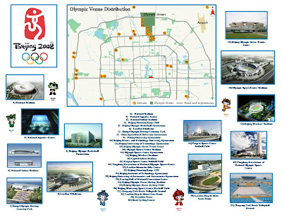
The exhibit also features the newest map of China published by the National Geographic in 2006. The GRMC created a special map of the Olympic venues with photographs of the new buildings (shown). Other maps from the GRMC featured in the exhibit are Chinese Linguistic Groups and Clothing Recommendations for Travel in China published by the Central Intelligence Agency and a map showing particulate air pollution in selected cities from 1990-1995.

These maps will be available for circulation on August 25. Maps from the GRMC circulate for two weeks or longer.

For more information, please visit the GRMC Monday through Friday from 7:30 A.M. to 4:30 P.M.

Monday, July 28, 2008

Collection of Historic Maps in Digital Media Repository


Historic Maps in Ball State University Libraries' Digital Media Repository

The newest collection in the Ball State University Libraries’ Digital Media Repository is Muncie and Delaware County Historical Maps and Atlases. This digital collection features historic maps of Muncie and Delaware County, Indiana, dating from 1826 to 1903. Towns and township maps are included in the collection. An Atlas of Delaware County published in 1887 is also included. This collection features the use of Zoomify, which allows users to “zoom in” on details.

These maps are a valuable resource for those interested in the history and growth of Delaware County during the nineteenth century.

For more information about these maps, please contact the Archives and Special Collections in Bracken Library at 765/285-5078.

Maps of Yosemite National Park in Ball State University Libraries


Maps of Yosemite National Park in the Geospatial Resources & Map Collection

Wildfires in California have now moved into an area threatening Yosemite National Park. Researchers can access dozens of maps of the park in the Geospatial Resources & Map Collection on the second floor of Bracken Library.

The Map Collection includes a new map of the park and the surrounding wilderness from 2007. This map is created with relief shown by contours and shading. Six bird’s-eye views and a map of “Yosemite creek past and present” are also included. The verso of the map tells the geologic “story” of Yosemite Valley.

Another interesting map of the national park is Satellite Orthoimage of Yosemite Valley, Yosemite National Park, California. This map of the area was created from satellite images. Map of Yosemite Region is another interesting map in the GRMC that includes a table of campground information. Maps of Yosemite Valley, Yosemite National Park, Mariposa, Bass Lake, the Sierra National Forest, and many other lakes and recreation areas are also included.

Current topographic maps of the park are also available in the GRMC, and many road maps of the state of California include inset maps of Yosemite. An official guide map of Yosemite National Park dated from 1931 is also included in the Collection, as well as a topographic map of the park from 1946.

Maps from the GRMC circulate for two weeks or longer.

Please contact the GRMC Monday through Friday from 7:30 A.M. to 4:30 P.M. at 765/285-1097.

Thursday, July 24, 2008

New Map Exhibit in Ball State University Libraries


Dogs Days of Summer: New Map Exhibit in the GRMC

University Libraries’ Geospatial Resources & Map Collection student-assistant Justine Payne created a special map exhibit for the “dog days of summer.” Payne created a map display featuring the top twenty most popular dog breeds in America according to the American Kennel Club.

The map shows a photograph of each dog in the location where the breed originated. The most popular dog, the Labrador retriever, for example, originated in Newfoundland, Canada. The Yorkshire terrier, at number two, is from England, and the German shepherd, the third most popular breed, is obviously from Germany. Germany is the most common site, with seven dog breeds originating there.

Justine Payne is a junior from Lafayette, Indiana, majoring in public history. She has worked in the GRMC for one year.

Please visit the GRMC on the second floor of Bracken Library to view this special map exhibit on display through August.

Thursday, July 10, 2008

Maps of Iran in Ball State University Libraries

Maps of Iran in the GRMC

Another location in the headlines is Iran. The Geospatial Resources & Map Collection in Bracken Library includes a set of maps of Iran, including provinces and cities of the country.

Iran Country Profile is a map of the country created in 2004 by the Central Intelligence Agency Cartography Center. This map includes a comparative area map, location map, and a list of major historical events in Iran since 1908. The map features ancillary maps of regional physiography, population density, ethno-religious distribution, key petroleum sector facilities, Southern Caspian energy prospects, and the Strait of Hormuz.

The Map Collection includes road maps, physical maps, tourist maps of the country, provinces, and cities, and maps of the people of Iran. Many of these maps are printed in English, Persian, and French. Some of the historical maps in the Collection feature bright illustrations of local costumes and handicrafts.

The GRMC also includes a set of international nautical charts including the areas surrounding Iran. Many of these nautical charts include basic maps of coastal areas.

Maps of the cities of Iran include a set of varied maps of Tehran. The New Map of Tehran includes telephone directories for accommodations for tourists and distance charts. The Guide Map of Yazd includes an index to historical monuments and sightseeing, and selected buildings are shown pictorially. The GRMC also includes maps of Isfahan city and province—both printed in Persian and English.

The Atlas Collection includes several atlases of Iran. The Historical Atlas of Iran and Atlas d’Iran are newer materials. The Atlas d’Iran is printed in French with English captions. The 1956 Atlas of Geological Maps of Southwest Persia was published by an oil company. An atlas about Iran’s White Revolution is also located in the Atlas Collection.

A current exhibit in the GRMC features a map showing the range of Iran’s missiles to the surrounding areas of the Middle East and parts of Europe and Asia.

Maps from the GRMC circulate for two weeks or longer. Atlases circulate for 28 days.

Please visit the GRMC between 7:30 A.M. and 4:30 P.M. Monday through Friday throughout the summer to view the Iran exhibit or research these resources.

Kilauea Caldera Maps in Ball State University Libraries


In the News: GRMC Maps of Hawaii’s Kilauea Volcano

The Geospatial Resources & Map Collection has a number of maps showing the Kilauea Volcano on Hawaii’s Big Island, which is currently erupting. Volcano watchers and scientists report lava bursts of up to 150 feet over the last few days, as ocean water invades the underground lava tubes.

The GRMC includes many topographic maps of the volcano at varying scales. The U.S. Geological Survey map shown is at 1:24,000-scale. The Map Collection also includes topographic maps of the Big Island of Hawaii from the Army Map Service.

A 1995 National Geographic map of the state of Hawaii includes an inset map of Kilauea Caldera (also shown). And a 1989 Geoprint map of the Big Island includes a descriptive inset map with marked features of the Kilauea Caldera.

Maps of Hawaii’s Volcanoes National Park are also available in the GRMC. The map Hawaii’s Volcanoes Revealed from the GRMC is also available digitally at http://purl.access.gpo.gov/GPO/LPS46014 . This colorful map features an image of Hawaii illuminated to emphasize sea-floor relief and includes ancillary maps showing bathymetry of the northwest Pacific Ocean, a 3-D perspective view of Hawaii, and an interpretive map of Hawaii’s volcanoes.

The GRMC also includes other maps about volcanoes around the world. Volcanoes of the World, This Dynamic Planet: World Map of Volcanoes, Earthquakes, Impact Craters, and Plate Tectonics and Earth’s Fractured Surface: Living on the Edge are some of the maps in the GRMC including information and graphics on volcanoes. The World Atlas of Natural Hazards is also available in the GRMC.

Please contact the GRMC for more information about these resources at 765/285-1097.

Tuesday, July 08, 2008

Colombia Maps and Atlases from Ball State University Libraries


Maps in the News: Colombia Maps Available in the Geospatial Resources & Map Collection

The South American country of Colombia has been in the news thanks to a daring hostage rescue by the Colombian military. The Geospatial Resources & Map Collection in Bracken Library has a number of resources about the country for those interested in learning more about Colombia.

A travel map of Colombia published in 2004 is an excellent resource. The map has inset maps of the territories of the country, San Andres, Povidencia y Santa Catalina, Malpelo, and Colombia in the world. The administrative and political divisions are also shown on the main map. Depths and contours are shown in gradient tints, and the major highways of the country are displayed. The map also includes indexes, a distance table, and illustrations.

Numerous other maps of Colombia created in varying scales are also available from the GRMC, including a unique physical map of the country. Topographic quadrant maps, a map of major industrial installations, and a map of terrain and transportation are all dated from 1944. The Map Collection also includes maps of Colombian cities, including Bogota, Medellin, Cali, Neiva, and Barranquilla.

The Atlas Collection includes a variety of atlases of Colombia. The atlases include physical maps of the country and street maps, but The Coffee Atlas of Colombia and The School Atlas of Colombia are also available.

Contact the GRMC at 765/285-1097 for more information about these resources.

Wednesday, July 02, 2008

July Map of the Month in University Libraries

July 2008 GRMC “Map of the Month” Is Disastrous

The “Map of the Month” in the Ball State University Libraries Geospatial Resources & Map Collection is a map showing great disasters that have occurred in North America—mostly in the summer. The map, Natural Hazards of North America, was produced as a supplement for National Geographic magazine in July of 1998. This map features historic hailstorms, droughts, tornadoes, and hurricanes, wildfires, and landslides.

Maps from the GRMC may be borrowed for two weeks or longer. The GRMC maintains multiple copies of National Geographic maps, so both sides of these maps can be displayed during class presentations or exhibits.

Contact the GRMC Monday through Friday from 7:30 A.M. to 4:30 P.M. for more information about this map or any other resources.

June 2008 Activities in the GRMC


What’s Happening in the GRMC? June 2008

During the month of June, a major focus of the Geospatial Resources & Map Collection was providing resources for educators:

The GIS Specialist began creating custom GIS data for Prairie Creek Reservoir in Muncie for a professor from the Department of Natural Resources/Environmental Management. The Map Collection Assistant consulted with two beginning teachers and created custom lesson plans using maps from the GRMC for use in middle school classrooms in coordination with the GRMC online maps tutorials on the Web page. Some of these lesson plans are available for use at http://ilocker.bsu.edu/users/mgentry/WORLD_SHARED

Researchers visiting the GRMC during the month of June included a marketing thesis student referencing topographic maps of Indiana, a faculty member using a World War I-era map of the Middle East for a class, and a new landowner researching the location of oil wells on his property. Students studying the history of Huntington County used maps and atlases in the GRMC, genealogists researched historic maps of Germany and Poland for their family history, and students from Geography 240 and 101 used maps from the GRMC for class assignments.

Staff of the GRMC created a map of the United States showing college towns for a graduate student in sociology. The map was printed on one of the large-format plotters available in the GRMC.

For more information about maps, atlases, GIS technology, or using the large-format plotters, please contact the GRMC at 765/285-1097.

Friday, June 27, 2008

Zimbabwe Maps in the Ball State University Libraries


Maps in the News: Un-cataloged Maps of Zimbabwe in the GRMC

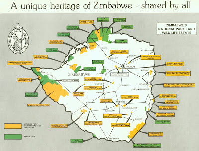
The violence surrounding the elections in Zimbabwe has been widely covered on the news. The Geospatial Resources & Map Collection on the second floor of Bracken Library has several maps of Zimbabwe available for those interested in learning about this country in southern Africa.

A 2002 travel map of Zimbabwe and several basic maps produced by the Central Intelligence Agency are available in the ready-reference area of the GRMC. These maps have been cataloged and can be viewed in the University Libraries’ CardCat online catalog. However, the GRMC also has many maps of Zimbabwe that are not listed in the catalog. There are also maps of the country featuring its former names, Southern Rhodesia, Zimbabwe Rhodesia, Rhodesia, and the Federation of Rhodesia and Nyasaland.

Many maps of Zimbabwe in the GRMC would be excellent for studying the climate, physical features, and industry of the country. The Collection features a map of the average rainfall of Southern Rhodesia, a physical map of Zimbabwe, a map of the minerals of Zimbabwe, a map of gold mines in the country, and a soil map of Zimbabwe Rhodesia.

The GRMC has maps of Zimbabwe showing tribal trust lands, the location of tribes and languages shortly after independence, a map showing the African and European population distribution of the country in 1969, and maps showing the percentages of Ndebele and Shona speakers by district.

Several beautiful tourist maps of Zimbabwe and Rhodesia are included in the GRMC. There are also maps of the national parks and a gazetteer road map of the Federation of Rhodesia and Nyasaland. Regional maps including Zambia and Malawi, and city maps of Bulawago and Harare and its former name Salisbury are also available in the GRMC.

All maps—cataloged and un-cataloged—can be borrowed from the GRMC for two weeks or longer.

Contact the GRMC for more information about the collection of Zimbabwe maps or any other resources for research and learning.

Tuesday, June 24, 2008

Flood Maps Available in the Ball State University Libraries

Maps in the News: Flood Maps Available in the GRMC

In the wake of recent historic flooding throughout the Midwest, home owners are reevaluating their decisions regarding the purchase of flood insurance. The Geospatial Resources & Map Collection in Bracken Library offers a large collection of floodway and flood boundary maps for research.

The Map Collection includes a large set of the United States Federal Emergency Management Agency flood boundary maps, which show the boundaries of 100-year and 500-year floods. The Collection includes map sets of 28 Indiana counties and over 100 Indiana towns, including Indianapolis, Martinsville, Columbus, and Prince’s Lake—the site of a dam failure during recent flooding.

The U.S. Army Corps of Engineers created flood maps based on U.S. Geological Survey topographic maps. Flood Areas: White River, Buck Creek, Killbuck Creek, Jakes Creek, Muncie, Indiana and Little Calumet River, Indiana: Summary of Flood Control Features are local maps available from the GRMC. The Corps of Engineers maps also include a United States map of civil works activities, Central and Southern Florida Flood Control Project map, Mississippi River, Hannibal, Missouri: Flood Control Project, Fountain Creek at Pueblo Flood Forecast map, and Major Flood Damage Areas, Minnesota and South Dakota. Flood maps created by the Corps of other towns on the Mississippi River, the Rock River, the Raccoon River, and the Cedar River are also available for research from the GRMC, as well as flood areas in Florida.

Another set of 30 flood maps of Indiana and Kentucky cover the Ohio River flood plain. A map of the Potomac River Basin’s major flood problem areas is also in the Collection. Also an electronic resource, U.S. Army Corps of Engineers Civil Works Activities, is available in the GRMC.
Researchers requiring flood maps can borrow maps for two weeks or longer. Visit the Geospatial Resources & Map Collection Monday through Friday from 7:30 A.M. to 4:30 P.M.