

GCMC Maps Part of International Festival Display
The Rinker Center for International Programs sponsored the International Festival on Friday, October 6, in the Student Center Cardinal Hall. The International Festival, or I-Fest, is an educational and entertaining event featuring cultural displays from 85 different countries.
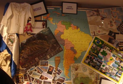
The Latin America booth at the I-Fest featured maps borrowed from the Geospatial Center & Map Collection as part of their display. Staff from the GCMC assisted Jacqueline Hanoman and Lucia Martinez selecting the various maps used for the display. A variety of maps were chosen to decorate the booth and provide information about Latin American countries, the archaeology of Central and South America, history, legends and cultural features.
The booth also featured PowerPoint presentations on Brazil, Colombia, Nicaragua, Ecuador, and Venezuela. Visitors to the booth also enjoyed some traditional music and food from Latin America. Latin American students were also available at the booth to teach about their countries and native cultures. Jacqueline Hanoman said that the idea of the booth was "to emphasize the unity of the Latin American nations" but also to "distinguish the diversity of the nations." Hanoman said that using maps to decorate their display really "made the difference," and she said that she will definitely use more maps again for other presentations. The GCMC was very honored to provide maps for such a beautiful display (photgraphed above).
Please contact the GCMC if you would like to borrow maps for a presentation or display. The staff of the GCMC would be happy to help choose maps and will even encapsulate maps for a more convenient display option.
No comments:
Post a Comment