Wednesday, May 28, 2014

Maps in the News


Maps in the News:  Honor Killings

News of a reported “honor killing” of a woman by her family in Pakistan is shocking.  This map (click to enlarge) from the State of Women in the World atlas by Joni Seager identifies countries where honor killings regularly occur. 

“’Honor killing’ is a term used to identify a form of legally or socially sanctioned revenged exercised within a family against a woman who is deemed to have soiled the family’s honor, usually through behavior that is judged to be sexually inappropriate.”  Between 2002 and 2006 in Pakistan, more than 4,100 honor killings occurred.  According to the map, three women per day in Pakistan are murdered in honor killings.

The State of the Women in the World atlas is available in the Ball State University Libraries’ GIS Research and Map Collection and the Atlas Collection on the second floor of Bracken Library.

Tuesday, May 27, 2014

ESRI to Provide Cloud-Based GIS Software to American Schools


ESRI to Provide Free Educational Software to American Schools

From the White House Science Fair Fact Sheet and Backgrounder, whitehouse.gov:

In continuing its support of education and in line with President Obama’s ConnectED vision of opening new opportunity through technology in the classroom, ESRI will provide free access to ArcGIS Online Organization accounts to every K-12 school in the United States.  This is the same GIS technology used by government and business.

ArcGIS Online allows users to map and analyze data, create and share content, and collaborate in the cloud via computers, tablets, or smartphones.  This commitment expands on ESRI’s successful program in pilot schools at all levels across the country.  This access will allow students to do projects of unlimited content—from global to local.  Students will be building knowledge and skills for college and career as well as building their community.

Education Week presented an article providing more information about the ESRI donation.


Indiana Summer Roads Trips Map available from Ball State University Libraries


Hitting the Crossroads:  Indiana Road Trips Map

Memorial Day marks the unofficial start of summer and the biggest season for Americans getting behind the wheel.  The Ball State University Libraries’ GIS Research and Map Collection (GRMC) is commemorating the summer travel season with an exhibit featuring a new map, Hit the Crossroads:  Indiana Summer Road Trips (above, click to enlarge).  The map is displayed in the front windows of the GRMC on the second floor of Bracken Library.

The map describes some of the unique places to visit around the state.  State parks, national landmarks, and historic and memorial sites are detailed on the map.  Roadside attractions like a giant leg sundial, the world’s largest yo-yo, and the world’s largest rocking chair are also identified.  The map also features unique diners and drive-ins.

The map is part of a series of Indiana maps created by the GRMC commemorating the state’s rich history and culture.  Indiana sports history and movies that take place in Indiana are also featured on maps in the series.  The Indiana maps, including the new road trip map, are available for use in the classroom or for printing from the Cardinal Scholar Digital Repository.

For more information, please contact the GRMC at 765-285-1097. 

Friday, May 23, 2014

Ball State University Libraries' GIS Research and Map Collection Holiday Hours


The Ball State University Libraries' GIS Research and Map Collection will be closed on Monday, May 26 for Memorial Day and will reopen at 7:30 am on Tuesday, May 27.

Friday, May 16, 2014

Segregation Map from Ball State University Libraries


Mapping History:  Sixtieth Anniversary of Brown versus the Board of Education 

The landmark United States Supreme Court decision, Brown versus the Board of Education, was handed down on May 17, 1954.  The decision overturned the Plessy versus Ferguson decision which allowed state-sponsored segregation as “separate but equal.” 

The map above from the United States History Atlas (click to enlarge) is currently exhibited in and available from the Ball State University Libraries’ GIS Research and Map Collection (GRMC).  The map identifies state segregation policies as they existed in 1954 at the time of the ruling.  The Brown decision allowed for integration and declared separate public schools for students as unconstitutional, an important event in the civil rights movement.

For more information about maps depicting historic events, please contact the GRMC at 765-285-1097.


Monday, May 12, 2014

Nigeria Maps Available from Ball State University Libraries


Maps in the News:  #BringBackOurGirls:  Nigeria and the Education of Girls

The Ball State University Libraries’ GIS Research and Map Collection (GRMC) and Atlas Collection include extensive cartographic resources that can be used to depict events happening around the world.  Maps can serve as an excellent visual aid for understanding complex issues.

At least 276 girls in the northern town of Chibok, Nigeria were abducted from their school by the Boko Haram group.  Some authorities believe that many of the girls were sent to neighboring Niger, Cameroon, and Chad. 

Nigeria is a main source in the sex trafficking industry.  The map above (click to enlarge) is from the Penguin State of the World Atlas available in the GRMC and Atlas Collection.  The map details some of the routes used in the sex trafficking industry using data from 2012.

Another map from the same atlas shows the percentage of children of the correct age enrolled in primary school.  Nigeria falls into the 50-69% bracket for this statistic. 

The map above from the Penguin Atlas of Women in the World shows that Nigeria has fewer than 49% of its girls enrolled in secondary schools.  And another map shows lower percentages for tertiary education—only 20-39% of girls in Nigeria attend the university.  And only 17% of the professors are women.

Women in Nigeria also face discrimination in property ownership.  According to the map from the Penguin Atlas of Women in the World, there is widespread discrimination against women inheriting, owning, or controlling property, land, and wealth—sometimes supported by civil, religious, or customary laws.

The map of Nigeria published by the Central Intelligence Agency shows the location of the Boko Haram’s stronghold state, Borno, in northeastern Nigeria.  The schoolgirls were abducted from Chibok, which is just southwest of Maiduguri.  This map and the most up-to-date maps of countries around the world are available in the Maps of the World collection of the Libraries’ Digital Media Repository.

For more information about these maps and atlases, please contact the GRMC at 765-285-1097.  The GRMC is open from 7:30 to 4:30 during the summer.


Tuesday, May 06, 2014

Resources for Teachers from the Ball State University Libraries


Teacher Appreciation Day: Cartographic Resources for the Social Studies Classroom

Cardinal Scholar is an institutional repository available for use by the Ball State University community.  The GIS Research and Map Collection (GRMC) in Bracken Library offers maps and other resources for use in classrooms.  Now teachers can access Cardinal Scholar to use many of these available resources from the GRMC for education and learning.

Using Cardinal Scholar

Access resources by visiting the University Libraries main Web page or directly from Cardinal Scholar.   To find all of the available resources from the GRMC in Cardinal Scholar, click on "Communities and Collections" on the left of the page.  Then scroll down the list under the "Information Technology" section to “GIS Research & Map Collection.”  Then either type a key word, topic, or geographical place in the search box or browse by the title.  A list of resources including maps, games, posters, lesson plan ideas, and classroom activities will appear.  (The GRMC is constantly updating the educational resources in Cardinal Scholar, so check for additions from time to time).  Teachers and students can click on the file of the resource and save it for use in the classroom.  The GRMC has two large-format color plotter printers available for printing some of the large maps or posters, and a large-format laminator is also available.  (The GRMC charges directly to the Bursar for printing and laminating). 

Lesson Plan Guides and Tutorials


The GIS Research and Map Collection offers from Cardinal Scholar a lesson plan guide for teachers on how to use maps in the classroom:  Teaching with Maps:  Lesson Plan Guide from the GRMC for Using Maps in the Classroom.  This guide provides sample maps and lessons for teachers of social studies, science, English/literature, and economics.  The lessons range in scope and include using topographic maps, mapping prehistoric dinosaurs, studying Indiana authors, tracking the legendary Big Foot, and using football to study U.S. geography and history.  Other guides available from Cardinal Scholar include cartographic guides on women’s history, Black history, using Sanborn insurance and topographic maps, parts of maps, map projections, and genealogy resources.

Final Projects

Teachers can review activities to use as final projects for students like using a map of the Amazon to create an alphabet book, creating a map of Canada’s famous people and inventions, and students working in groups to create a pictorial map of Indiana history as a final project.  Each of these finished projects can be accessed from Cardinal Scholar.

Classroom Activities

Teachers can copy worksheets and other activities from Cardinal Scholar:  Africa Map Search and Canada Map Scavenger can each be completed using one map of Africa and Canada.  Students can learn about the events of the Cold War and use the 1989 world map from Cardinal Scholar to review where the tensions between the former Soviet Union and the United States were located.  Teachers can show world development using the Earth at Night map activity, demonstrate the world geography of the Olympic Games, and review European geography with the Santa Travels Europe worksheet.  Elementary and middle school students can test their knowledge of state capitals with the U.S. Capitals Puzzle game.  And teachers can even find out from Cardinal Scholar and the GRMC how to create a classroom seating chart using latitude and longitude.

Maps

The GIS Research and Map Collection creates custom maps and posters for education and learning.  These resources are all available for use from Cardinal Scholar, including the American Folklore and Legends map, a map about the Heritage of Southern Asia, and Storybook England map, which displays great works of children’s literature by English authors.  A new series features maps of women's issues around the world.  Teachers may also wish to use some of the historical maps like the map of John Dillinger's robberies, the range of the buffalo, La Salle and the Mississippi River, or Martin Luther King, Jr.  

Teachers can print out the educational posters from the GRMC including cultural maps of numerous countries like Pakistan and Argentina, a poster showing the effects of global warming over time on an Alaskan glacier, and posters to commemorate Black History Month, Women’s History Month, and Veterans Day.

Games

Teachers can also print the large maps created by the GIS Research & Map Collection to be used as board games:  Africa Trek Map Game features a large map of Africa.  Teachers can create game pieces and cards so students can move around the map of Africa, hopefully while learning the geography of the continent.  Using the Quest for Heroes I-Spy Game, students must race to find the heroes by identifying in which state they are located.  A new game, Europe Brainstorming Geography Game, is based on the popular Scattegories game.

Contact the staff of the GIS Research and Map Collection for any questions, concerns, or information about using other maps or educational resources or about using Cardinal Scholar.  The GRMC is open Monday through Friday during the summer from 7:30 a.m to 4:30 p.m.  The telephone number for the GRMC is 765-285-1097.


Friday, April 25, 2014

The Geography of America's Pastime

Wrigley Field, Chicago 1930
GIS Research and Map Collection


Cubs or Cardinals? Mapping Baseball Fandom

The New York Times’ “The Upshot” is a Web page that analyzes politics, policy, and other subjects and creates visualizations based on various data.  The site created a map showing the predominant fans of Major League Baseball teams.  “Fans may not list which team they favor on the census, but millions of them do make their preferences public on Facebook.” 

Facebook created a map of baseball fans by county, but this new map was created using ZIP codes.  The interactive map of the United States allows users to see the most popular team in their local area and also view a table of the top three teams in each ZIP code.

The map creators also generated 14 maps of baseball’s biggest rivalries with proposed names for the borderlines.  Users can suggest new maps and names via Twitter or Facebook, and the maps will be regularly updated.

Tuesday, April 22, 2014

Environmental Maps and Atlases Available from Ball State University Libraries


Soil degradation


Everglades 1973


Everglades 2002


Arctic Ice 1979

Arctic Ice 2003

The Cartography of Earth Day

Today is Earth Day, and the Ball State University Libraries’ GIS Research and Map Collection (GRMC) on the second floor of Bracken Library includes many resources for researchers studying issues of the environment.  The Map Collection includes flood plain maps for numerous areas, topographic maps that show development for areas around the world, soil surveys and maps from counties around the country, Gap Analysis electronic resources for land cover, forest types, and other factors, maps of important farmlands in counties around the United States, natural gas and other energy maps, and national and state park and forest maps.

The Atlas Collection also includes a number of resources about the environment.  The maps and photographs shown above are from the atlas One Planet, Many People: Atlas of Our Changing Environment, which was published by the United Nations Environment Program in 2005.  Atlases in the collection cover a broad range of environmental issues, including endangered species, polluted waters, urban development, and soil degradation (shown above).  Atlas of Contemporary America: Portrait of a Nation, Atlas of the Great Barrier Reef, World Atlas of Great Apes and Their Conservation, Ocean: An Illustrated Atlas, Atlas of Wildlife, and Atlas of Global Development also include maps about the environment.

For a complete list of environmental resources, researchers can access a cartographic research guide on the GRMC Web page.  For more information, please contact the GRMC at 765-285-1097.


Thursday, April 17, 2014

Maps in the News

Mapping Places in the News

The Ball State University Libraries' GIS Research and Map Collection (GRMC) houses a collection of over 140,000 maps available for research and learning.  Maps from around the world from the GRMC offer a great resource for learning about places in the news.


This map of Boston shows the location of the finish line of the Boston Marathon (click to enlarge).  The Boston Picture and Street Map was published by Olde South Publishing in 2000.


This is an inset map from the Titanic Reference Map available from the GRMC. The map shows the ship's reported and actual route and where rescue ships were located.  RMS Titanic sank on April 15, 1912. 


A ferry capsized off the coast of South Korea this week.  The ferry was traveling to Cheju-do Island seen at the bottom of this map (click to enlarge).  This map of South Korea was published by the Central Intelligence Agency.


Friday, April 18 marks the anniversary of the 1906 earthquake and fire in San Francisco. This panoramic map shows the city just after the disaster.  The map is featured on the San Francisco at the Millennium map in the GRMC.


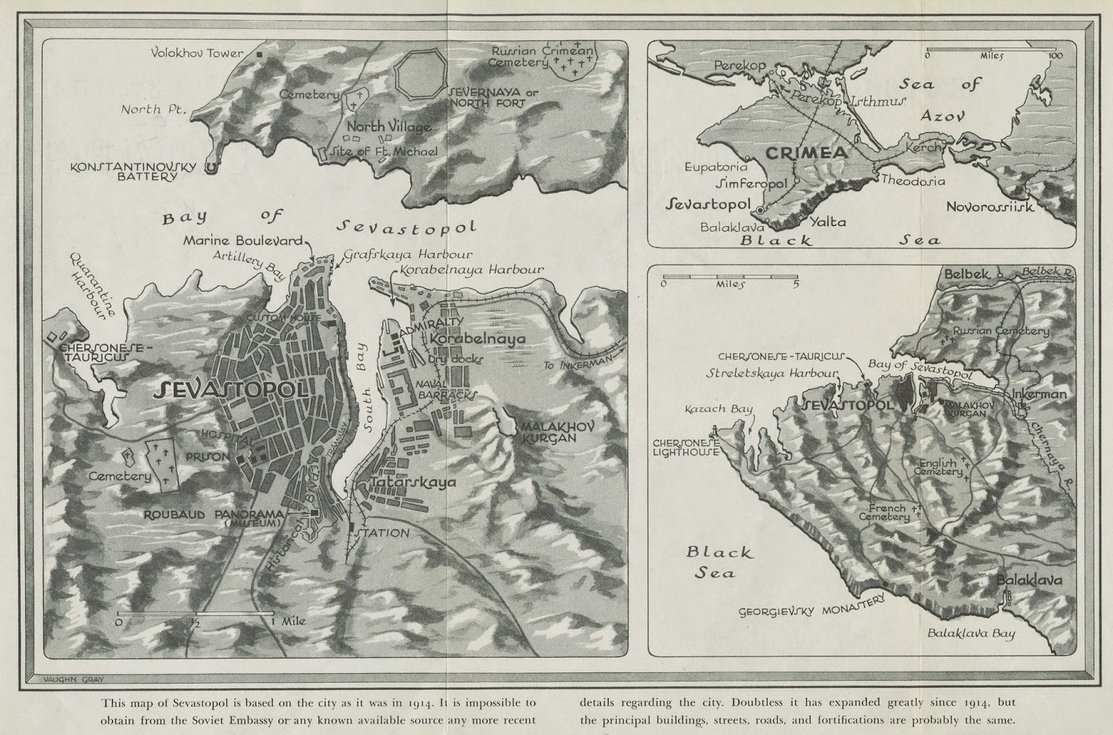
This map of Sevastopol, Crimea--formerly of the Ukraine--was published in the book, Last Days of Sevastopol by Boris Voyetekhov in 1943.  The map notes, "This map of Sevastopol is based on the city as it was in 1914. It is impossible to obtain from the Soviet Embassy or any known available source any more recent details regarding the city...."


April is Child Abuse Prevention Month.  This map shows the rates of reported child abuse and child fatalities due to abuse and neglect.  The map is from the Allyn Bacon Social Atlas of the United States available from the GRMC and the Atlas Collection in Bracken Library.

Maps from the GRMC circulate for two weeks or longer.  Atlases circulate for 28 days or longer.  For more information, please contact the GRMC at 765-285-1097.

Thursday, April 10, 2014

Speaker from The Polis Center at Ball State University Libraries


GIS Speaker at Ball State University Libraries

The Ball State University Geographic Information Systems (GIS) Knowledge Group is hosting a speaker at Bracken Library at 7:30 p.m. on Thursday, April 17.  Dr. David Bodenhamer will present From Historical GIS to Deep Mapping:  The Emergence of Spatial Humanities in Bracken Library room 104.

Dr. Bodenhamer is the Executive Director of The Polis Center and Professor in the Department of History at Indiana University-Purdue University at Indianapolis.  He has served as strategic and organizational consultant to universities, government agencies, and not-for-profit and faith-based organizations across the United States and in Europe.  An active researcher, Bodenhamer is author or editor of ten books and has published over 30 journal articles and book chapters.  He has presented to audiences on four continents ranging from legal and constitutional history to the use of GIS and advanced information technologies in academic and community-based research.

Bodenhamer’s works include The Spatial Humanities: GIS and the Future of Humanities Scholarship (Indiana University Press, 2010) and the forthcoming book Deep Maps and Spatial Narratives (Indiana University Press, 2014).

The Polis Center is a self-funded research unit of the Indiana University School of Liberal Arts at IUPUI. The Center works with professional and scholarly communities, especially through application of digital technologies such as GIS and other geospatial tools.  Major efforts include projects with national and state departments of homeland security, public health organizations, and research centers.

The presentation is free and open to the public.  Free parking is available in the Emens Parking Garage next to Bracken Library after 7:00 p.m.

For more information about the program, please contact Angela Gibson, GIS Specialist in the GIS Research and Map Collection at 765-285-1097.

Wednesday, April 09, 2014

Appomattox, Virginia Topographic Map Shows Site of Civil War Surrender


Appomattox on the Map: Map of the Site of the Civil War Surrender Available from Ball State University Libraries

On April 9, 1865 General Robert E. Lee surrendered to Lieutenant General Ulysses S. Grant at the home of Wilmer and Virginia McLean near Appomattox, Virginia.  The house is now included in the Appomattox Court House National Historic Park. 

The McLean House is identified on this U.S. Geological Survey topographic map (above, click to enlarge) from the Ball State University Libraries’ GIS Research and Map Collection (GRMC).  The GRMC houses thousands of these quadrant maps from around the United States.  These maps are an excellent resource for cartographic research and include relief lines, intermittent and permanent bodies of water, roads, government boundaries, and prominent buildings and other cultural features. Historic topographic maps and thematic maps about the Civil War are also available in the GRMC.

The second satellite image from Google Earth shows the McLean House and the surrounding buildings of the park.  The Web page, What Was There, features a photograph of the McLean House taken at the surrender that can be “faded” to see the house today.

Maps from the GRMC may be circulated for two weeks or longer.  For more information, please contact the GRMC at 765-285-1097.

Tuesday, April 08, 2014

Native American Documentary to Premiere in Muncie


The Lenape on the Wapahani River Documentary Premieres Saturday, April 12

A new documentary produced by students at Ball State University explores the source of names like “Muncie,” “Delaware County,” “Anderson,” and “Wapahani High School” and the interesting history of the Delaware Native Americans in Muncie, Indiana and will premiere on Saturday, April 12 at the Minnetrista Cultural Center at 1:00 p.m. 

The Lenape on the Wapahani River is the product of an immersive learning project taught by Chris Flook, Instructor in the Department of Telecommunications.  The documentary film was produced by students from the Departments of Telecommunications, Digital Storytelling, Natural Resources and Environmental Management, and Anthropology.  The project provides educational resources about the Delaware (or Lenape) Native Americans during their time in east central Indiana from the 1790’s through 1821. 

Partnering with the Delaware Tribe of Indians in Bartlesville, Oklahoma, and the Conner Prairie Interactive History Park in Fishers, Indiana, the project’s documentary and associated Web page provide a rich account of the Delaware’s often overlooked experience in Indiana.

The documentary will also broadcast on WIPB-TV on the following dates and times:

·         Sunday, April 13 at 12:30 p.m.
·         Monday, April 14 at 11:30 p.m.
·         Saturday, April 19 at 11 a.m.
·         Saturday, April 26 at 11 a.m.

The project was generously funded by the Hamer and Phyllis Shafer Foundation and was supported by the Building Better Communities Fellows program.  For more information about the film, please contact Chris Flook at 765-285-1480.

Tuesday, April 01, 2014

April Fools' Map Available from Ball State University Libraries


Skates or States? April Fools’ Map Activity from Ball State University Libraries

The Ball State University Libraries’ GIS Research and Map Collection (GRMC) creates custom cartographic resources for K-12 classroom teachers, including lesson plans, cartographic games, tutorials, and custom maps like the April Fools’ Map (above, click to enlarge).  Teachers can access the Cardinal Scholar institutional repository to print off and use many of these available resources from the GRMC for education and learning.

To find all of the available resources in Cardinal Scholar, click on “Browse by Communities and Collections.”  Scroll down to the Information Technology section:  The GRMC will be listed under “University Libraries.”  From the GRMC page, click on “browse by title.”  A list of resources including maps, posters, lesson plan ideas, and classroom activities will appear.  A search by subject or keyword is also available.  The GRMC is constantly updating the educational resources, so check for new additions from time to time.

Teachers can click on the title of the resource and save it for use in the classroom.  The lessons range in scope and grade level.  A lesson plan guide, Teaching with Maps, provides sample maps and lessons for teachers of social studies, science, English, and economics.  Other guides available from Cardinal Scholar including cartographic guides on women’s history, Black history, using Sanborn insurance maps in the history classroom, maps and map projections, and genealogy resources.

The April Fools’ map features labels of cities, states, lakes, crops, abbreviations, and mottoes that are incorrectly placed around the United States.  The map provides a good review of basic United States geography, and an answer sheet is included in the PDF file on Cardinal Scholar.

For more information about using Cardinal Scholar or any of the teaching materials, please contact the GRMC at 765-285-1097.
Monday, March 31, 2014

Baseball Maps Available from Ball State University Libraries


Opening Day: Baseball Maps Available from Ball State University Libraries

It’s Opening Day at ballparks around the country, and the Ball State University Libraries’ GIS Research and Map Collection (GRMC) offers baseball fans and others a glimpse at some baseball-related maps.

The GRMC includes a travel map locating all of the Major League Baseball stadiums.  The map also includes contact information for every major league, minor league, and independent professional baseball team in the U.S. and Canada.  

The Atlas of Sport available in the Atlas Collection features maps on the “American game,” including the map shown above (click to enlarge) depicting the number of high-school boys playing baseball in school leagues, with Iowa (site of Field of Dreams) leading the nation.

The GRMC has also created custom maps related to the history of baseball.  Black Diamonds: Negro League Baseball Teams, 1920-1949, (shown above) was created in association with the documentary Black Baseball in Indiana, a film created as an immersive learning project by students of Geralyn Strecker, Assistant Professor in the Department of English.  This map shows the location of the Negro League teams in the United States.  Photographs featured on the map are from the book Playing America’s Game by Michael L. Cooper.  The map is available for use from the CardinalScholar repository.  Copies of the map can be printed on the large-format plotter in the GRMC (charged to Bursar’s account) for exhibits, for use in the classroom, or personal use.


Another map, The Girls of Summer: All-American Girls Professional Baseball League Teams, 1943-1954, (click to enlarge above) commemorates the women who played professionally beginning during World War II.  The map was created for Women’s History Month and is based on the book A Whole New Ballgame: The Story of All-American Girls Professional Baseball League by Sue Macy available from the Educational Resources Collections.  This map is also available from Cardinal Scholar.  All maps are also available via interlibrary loan. 

For more information about these or other cartographic resources, please contact the GRMC at 765-285-1097.

Thursday, March 27, 2014

Oso, Washington Interactive Map


The New York Times created an interactive aerial map showing where houses and other structures were located before the landslide in Oso, Washington on Saturday.  Nearly fifty homes were located in the path of the mudslide made up of 15 million cubic yards of mud--three million dump truck loads left in the search field.  (The map above is from the British Broadcasting Corporation). 


Holy See/Vatican City Maps Available from Ball State University Libraries


Maps in the News:  Vatican City Maps Available from Ball State University Libraries

Today marked a historic first meeting between President Barack Obama and Pope Francis in Vatican City.  Ball State University Libraries’ GIS Research and Map Collection (GRMC) on the second floor of Bracken Library features several maps of Vatican City.

Vatican City is located completely with the city of Rome, Italy, and the “popout” map of Rome is a small folded map published in 2008 that includes a map of the grounds.  A 1995 National Geographic map of Italy also features an inset map of the grounds of the Holy See. 

The top map shown above was published by the Central Intelligence Agency and shows the location of the radio station, the post office, and the Papal Printing Office.  The second map shown above is a topographic map of Rome published by the Defense Mapping Agency by the War Office in 1943.

The third map shown of the Vatican City, Citta Del Vaticano, was published by the Visceglia Geographic Institute in Italian.  St. Peter’s Square is identified as “Piazza S. Pietro” on the map, and “Giardini Vaticani” marks the location of the gardens.  “Pinacoteca” is the Art Gallery located on the grounds.

Maps from the GRMC may be circulated for two weeks or longer.  The GRMC is open Monday through Friday from 8:00 to 5:00.  


Friday, March 21, 2014

Map of Exxon Valdez Oil Spill from Ball State University Libraries


Exxon Valdez Oil Spill Map from Ball State University Libraries

Monday, March 24 marks the 25th anniversary of the Exxon Valdez oil spill in Alaska.  The Valdez oil tanker ran aground in Prince William Sound, spilling millions of gallons of crude oil.  The map shows how the oil spill covered over 1,200 miles of shoreline.

The map above (click to enlarge) is from Mapping America’s Past: A Historical Atlas by Mark C. Carnes available from the Ball State University Libraries’ GIS Research and Map Collection on the second floor of Bracken Library.  This reference atlas features maps ranging from exploration, colonization, wars, and political issues to gender, ethnicity, education, religion, disease, and other demographics.  The atlas features detailed maps about the “making of Black Harlem” in New York, airports constructed by the WPA during the Great Depression, and maps of Levittown, Pennsylvania.

For more information, please contact the GRMC Monday through Friday from 8:00 to 5:00 at 765-285-1097.


Ball State University Libraries' YouTube Channel


Moving Pictures:  Ball State University Libraries’ Map Collections on YouTube

The Ball State University Libraries’ Digital Media Repository (DMR) provides online access to hundreds of digitized primary source materials, including artwork, architectural drawings, films, photographs, oral histories, and maps and atlases.  Historic maps and atlases from the GIS Research and Map Collection (GRMC) in Bracken Library can be accessed through the repository, and now can be viewed on YouTube.

The University Libraries’ YouTube channel allows users a different format for viewing some of the resources from the Digital Media Repository.  The Muncie and Delaware County Historical Maps Collection YouTube video includes historic plat maps of Muncie, maps from historic atlases, Sanborn Fire Insurance Maps dating back to the nineteenth century, and historic maps of the White River.

The Digital Media Repository provides access to several map collections:  The United States Transportation Maps collection includes historic railroad and road maps.  Ball State University Campus Maps show maps of the university dating back to the 1920’s.  American Cities Historic Maps features unique maps or urban views from 1855 through 1921.  Indiana Natural Resources Maps includes maps showing the locations of stone quarries, pipelines, and natural gas, coal, and petroleum deposits around the state.  International Historic Maps is an eclectic collection of maps from around the world, including a War Department map of Cuba published in 1911 and an 1867 map of the Ottoman Empire. Maps of the World is an excellent resource providing the most up-to-date maps of over 200 regional and national maps published by the Central Intelligence Agency.  Delaware County Aerial Plat Maps, Indiana Historic County Atlases, United States Soil Maps, and United States Topographic Maps are also available from the Digital Media Repository.

The GRMC is constantly adding resources to the DMR to enhance access to research and learning.  For more information about these collections and information about other cartographic resources, please contact the GRMC at 765-285-1097.

Monday, March 17, 2014

Ireland Maps Available from Ball State University Libraries


Happy St. Patrick's Day: Ireland Cartographic Guide Available from Ball State University Libraries

Students and other researchers of Ireland and Irish history can access a cartographic guide to resources available in Ball State University Libraries via the GIS Research & Map Collection (GRMC) Web page.  The subject guide, CartographicResources in Ball State University Libraries: Ireland and Irish History, can help researchers locate a variety of materials throughout the Library.

This guide provides a list with call numbers and locations of all of the maps, atlases, encyclopedias, and other resources available from University Libraries.  There are atlases for Celtic studies and Irish history in the Atlas Collection and also an atlas focusing specifically on Irish family histories, New Genealogical Atlas of Ireland.

Street maps for numerous cities in Ireland, nature reserve maps, topographic maps of Ireland, and maps covering Irish history are available from the GRMC.  The Irish Family Names Map features coats of arms and medieval locations, and maps showing the peat land and fishing resources of Ireland are also available.

The guide also includes a listing of a set of reproduced historical maps from the National Library of Ireland that are not yet cataloged but do circulate for two weeks or longer individually or as a set.  The maps shown above are from the Census Atlas of the United States, depicting the percentage of the population reporting Irish ancestry in the 2000 Census and the foreign born Irish population centers in 1900.

The cartographic guide is also available from Cardinal Scholar.  An Ireland map poster can also be accessed from Cardinal Scholar and used for research and learning in the classroom or for special presentations.

For more information about these resources or the cartographic guides, please contact the GIS Research & Map Collection at 765-285-1097.